Reichenstraßenfleet
The Reichenstraßenfleet in Hamburg's old town was an estuary of the Bille to the Alster . In the 9th century, the first port facilities of the early Hamburg settlement, which had emerged on a geest height immediately to the north, were located on this watercourse . In today's streetscape in Hamburg, these conditions are particularly evident in the ascent from the Old Fish Market and Domplatz to the Petrikirche . The harbor was a wooden landing stage about 120 meters long and six meters wide with posts and wattle, which stretched from the first market square of the settlement, the later fish market, to the Dornbusch . In the 12th century, the port was moved to the Alsterschleife - today's Nikolaifleet - near the Trostbrücke .
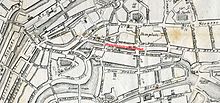
The Reichenstraßenfleet separated the old town from the Reichenstraßeninsel until the 19th century and ran from the Brauerstraßenfleet at the Meßberg for about 500 meters to the west and ended in the Nikolaifleet . The estuary was also called Bäckerstraßenfleet . As early as the 13th century, two bridges at the fish market and one bridge at the western end, for example at the later stock exchange bridge, are shown on historical maps. The construction of the Roland bridge, which crossed the canal at Dornbusch, is recorded for 1342, followed by the Kattrepels bridge at Hopfensack in 1564 and in 1843 the name of the western bridge as Börsenbrücke .
In 1877 the Reichenstraßenfleet was filled in to create a better connection between the town hall and the new Berlin train station . The resulting street was built on with rows of houses, which today form the northern side of the Große and Kleine Reichenstraße and are partially preserved. The names of the bridges remained in the street names that no longer lead over water.
Web links
Individual evidence
- ↑ Rita Bake: Various Worlds I. 45 historical stations through the Kontorhausviertel , published by the State Center for Political Education, p. 9 online as a pdf
- ^ Christian Hanke: Hamburgs street names tell history , Hamburg 2006, ISBN 3-929229-41-2 , pp. 44, 38 and 33
- ^ Manfred F. Fischer: The Chilehaus in Hamburg. Architecture and vision. With 28 plates by Klaus Frahm, Gebr. Mann Verlag, Berlin 1999, ISBN 3-7861-2299-7 , p. 16

