
Hamburg monastery gate
| Location of the Mitte district
until February 29, 2008 |
Location Klostertors
until February 29, 2008 |
|---|---|
 |
 |
| Basic data | |
| State : | Hamburg |
| District : | Hamburg-center |
| Area : | 3.6 km² |
| Residents : | 1,235 (2006) |
| Population density : | 343 inhabitants per km² |
| Area code : | 040 |
| Geographic location : | 53 ° 33 ' N , 10 ° 1' E |
| License plate : |
HH
|
| Duration: | 1951 to February 29, 2008 |

The former Hamburg district Klostertor existed from 1951 to 2008 and belonged to the Hamburg-Mitte district . It was named after an earlier city gate from the 19th century and comprised the eastern part of today's HafenCity and the western part of Hammerbrook including the Münzviertel and the wholesale market area . Most recently mainly characterized by fallow harbors and industrial areas, the district was dissolved as part of a comprehensive reorganization on March 1, 2008.
geography
The district was delimited as follows (starting in the north in a clockwise direction): north side of the Altmannbrücke , then following the railway line to the east to Nagelsweg. Follow Nagelsweg in the middle of the street to the south to Amsinckstraße ( B 4 ), this south-east to the bridge over the Bille , then through the Bille, the Brandshofer Schleuse and the Oberhafen to the railway facilities on Baakenwerder. Then the district boundary ran between Versmannstrasse and the railway line to Harburg to the middle of the Freihafen-Elbbrücke . There was the southernmost end of the district. The border then ran through the Norderelbe to the west to the Magdeburg harbor, through this and the Brooktorhafen to the Oberhafen, where it briefly jumped to the east and then led north between the railway line and Deichtorhallen . At the height of Deichtorplatz , the border jumped to the western side of the street of the monastery wall and then led to the Altmannbrücke.
history


The Klostertor district was initially formed in 1938 from parts of St. George . These parts of the area, located on the Hammerbrook and in earlier times also known as Auf dem Stadtdeich or Deichtorvorstadt , had been part of the suburb of St. Georg since 1830 , before they were administered by the Landherrschaft Hamm and Horn . The Klostertorhafen district was also built in 1938, encompassing most of what is now HafenCity and previously part of the southern old town . The name of both districts was derived from the monastery gate , which in turn was named after the St. Johannis monastery , which was located on the monastery wall at the time and was located between 1840 and 1860 at the height of today's Altmannbrücke in the fortification wall of Hamburg. With effect from May 11, 1951, the district administration law in the Free and Hanseatic City of Hamburg (1949) combined both districts to form the Klostertor district. The old district boundary is still present today as a purely technical district boundary between the districts 115 (Klostertor) and 116 (Klostertorhafen). It runs in the middle of the upper harbor.
When the new city fortifications were built from 1625 onwards, they did not want to give enemies an opportunity to attack the city from the Elbe . Numerous canals were filled in, only on Baumwall an opening for was Alster left. Outside of the fortifications, the Niederhafen at the Baumall and the Oberhafen in front of the Deichtor were built.
A new port was necessary for Hamburg to join the Zollverein . Two solutions were discussed during the planning phase: building a lock in the Elbe based on the example of the London port or a tidal port. The decision was made for the tidal harbor . The Zollkanal , which separates the Speicherstadt on Grasbrook from the old town , was laid out parallel to the wall frame .
After the great fire of 1842 , rubble was used to fill and build on the Hammerbrook - also in the area of today's monastery gate. Crossed by canals, a densely built residential and commercial quarter was built here from 1880, in which many workers displaced from the warehouse district found a new home. The area was almost completely destroyed by the bombing in July 1943. After the Second World War, the area - comparable to Hammerbrook - was rebuilt almost exclusively for commercial purposes. In the 1980s, the town was part across in Klostertor and Hammerbrook City Süd an office landscape on either side of the center channel built.
politics
Election results
The elections for the Hamburg citizenship from 1966 to 2004 brought the following results (for more recent election results see here ):
| Citizenship election | Greens / GAL 1 | SPD | CDU | FDP | Rest |
|---|---|---|---|---|---|
| 2004 | 41.1% | 25.6% | 20.7% | 4.6% | 8.0% |
| 2001 | 25.6% | 35.5% | 13.2% | 3.0% | 22.7% 2 |
| 1997 | 34.3% | 33.8% | 12.7% | 4.7% | 14.5% |
| 1993 | 30.7% | 36.6% | 12.4% | 0.5% | 19.8% 3 |
| 1991 | 24.8% | 42.7% | 20.5% | 2.1% | 9.9% |
| 1987 | 23.5% | 46.8% | 26.6% | 2.2% | 0.9% |
| 1986 | 23.1% | 42.5% | 32.1% | 1.9% | 0.4% |
| Dec 1982 | 21.5% | 51.5% | 23.4% | 2.6% | 1.0% |
| June 1982 | 20.6% | 40.4% | 33.3% | 3.5% | 2.2% |
| 1978 | 11.4% | 50.9% | 28.4% | 3.1% | 6.2% |
| 1974 | - | 46.5% | 37.7% | 9.9% | 5.9% |
| 1970 | - | 60.7% | 26.1% | 7.8% | 5.4% |
| 1966 | - | 63.4% | 26.5% | 6.7% | 3.4% |
Economy and Infrastructure
The former district of Klostertor was predominantly a district characterized by commercial uses. Only in the far north, around Münzplatz and on Högerdamm, was there still significant residential construction.
The HafenCity, which is currently under construction, comprises unused port areas on the northern bank of the Elbe and parts of the historic warehouse district . In addition to commercial uses, apartments will also be built here.
Established businesses

- The Hamburg Wholesale Market , located between the B 4 , Schleusenkanal and Stadtdeich, supplies Hamburg with flowers, fruit and vegetables every day. Its halls were built between 1956 and 1962 according to plans by Bernhard Hermkes , Gerhard Becker, Gottfried Schramm and Jürgen Elingius . Today's wholesale market replaced the Deichtor market in the old town .
- Port International Fruit Import Lippeltstrasse 1
- Company health insurance company Mobil Oil Filiale Hühnerposten 2
Traffic in the area


At the beginning of rail traffic in Germany, the stations for the routes to Berlin, Hanover and Lübeck were built in the Klostertor district. After the construction of the first connecting line , the southern terminus was named Klosterthor . The station built in 1866 was shut down and demolished in 1906 in favor of the new Hamburg Central Station . The Hannoversche Bahnhof on Lohseplatz was downgraded to a freight yard in the same year. From 1941 to 1944 it was also used to deport Jews to concentration camps .
The Federal Highway 4 , which here Amsinckstraße is, crosses the former district. The Hamburg Central Station with all rapid transit lines is located directly across the northern former district boundary in St. Georg . The Hammerbrook S-Bahn station on the S 3 and S 31 lines (in the direction of Pinneberg and Neugraben or Stade ) is also only 150 meters east of the former district. Underground line 4 was set up to develop the port area ; Continued and opened in 2012 to the HafenCity Universität underground station and in 2018 to the Elbbrücken underground station .
education
The building in which one of the first schools for the hard of hearing in Germany was established in 1952 has been located at Schultzweg (former address Münzstraße 6) since around 1884 . After merging with the school for the deaf in Hamburg-Hamm and their joint move to the Elbschule in Othmarschen in 2013, the building was occupied as of 2016 and now houses various social organizations.
The Rosenallee youth workshop houses, among other things, a carpentry shop, a printing shop and a kitchen. The youth workshop is closed after several years of successful work due to savings.
The primary and secondary school Norderstraße is already just outside the district in the area of St. Georg .
Culture and sights

music
The market hall event center has been housed in the former flower hall of the Deichtor market since 1976. Both well-known artists and newcomers perform here.
Fine arts
The Free Academy of the Arts , the Kunsthaus and the Kunstverein have been located right next to the market hall since 1995 . The art association founded in 1817, which was located at Ferdinandstor next to the Hamburger Kunsthalle before moving to Klostertor , mainly shows contemporary art on its 1,200 m² exhibition space. The Kunsthaus is operated by the Professional Association of Visual Artists Hamburg eV and mainly exhibits works by the members of the association on 500 m². The Free Academy of the Arts was founded in 1949 at the suggestion of Hans Henny Jahnn , who also became the first president, and Rolf Italiaander . His goal is to unite all the arts in Hamburg under one roof.
Buildings
After the Hamburg railway system had been redesigned, the Hühnerposten railway post office was built from 1902 to 1905 according to plans by Postbaurat Schuppe in the late Gothic style of the Brandenburg region. The expansion from 1923 to 1927 according to plans by Postbaurat Thieme brought it into line with the typical Hanseatic office buildings of that time. The Deichtorhaus (architects: Bothe, Richter, Teherani ) with the ZDF Studio Hamburg as the main tenant was completed in 2002. The Oberhafenkantine has been preserved as a typical port door and the most weird restaurant in Hamburg.
The representative Münzburg at Münzplatz 11, built by JHM Brekelbaum in 1886, was designed as a brick shell in the spirit of the Hanover School. It is an example of representative residential construction in inner-city areas. The Hammerbrookschleuse , built by Johann Hermann Maack (the builder of the Lombard Bridge ) in 1865/66, is today preserved as a technical cultural monument. It closes the lock channel to the Oberhafen.
In the area between Münzstraße, Schultzweg and the eastern end of Norderstraße there has been a three-story former school building since 1884 , which in its original function last housed the Hamburg School for the Hard of Hearing from 1952 until 2008 . In the current state (2019), the original high-level main entrance is walled up with a double-leaf door and the ramp that previously descended from Münzstraße, which is a little higher there, has been removed.

Former main post office at the chicken post

Münzburg at Münzplatz 11

View from Münzplatz to Münzstrasse

Former school building at Münzstraße 6, as in 2018
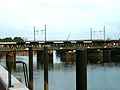
Oberhafenbrücke 2005


Oberhafenbrücke
At the transition to the former Klostertorhafen district , the new Oberhafenbrücke has been located between the Zollkanal and the Oberhafen since January 1, 2008 . Its historical predecessor was built from 1902 to 1904. Since the freight traffic was still carried out with sailing ships, it was designed as a swing bridge with four tracks for the railroad above and two lanes for road traffic on the lower level. Between December 26, 2007 and January 1, 2008 the Oberhafenbrücke was dismantled and replaced by a prefabricated new building. In the new building, great importance was attached to the protection of monuments and the two-storey structure was retained. The lower level of the car is used as a backdrop for many crime films. It was used for 101 years.
swell
- ↑ Hamburg's new district and urban district boundaries
- ↑ Hamburger Abendblatt, May 25, 2004
- ↑ https://elbschule.hamburg.de/ Website of the Elbschule
- ↑ see "Map of Hamburg and Altona 1884"
- ^ School for the hearing impaired Hamburg, school history, from 1950
- ↑ Michael Berndt: A very peculiar building - the Oberhafenbrücke in Hamburg. In: geschichtsspuren.de. March 22, 2005, accessed October 23, 2012 .
- ^ Spiegel Online on December 26, 2007