
Niederhafen


The Lower Harbor is situated on the northern bank of the Elbe part of the Port of Hamburg , who before the beginning of the 18th century as a port extension to the inland port protective Baumwall in the North Elbe has grown into it. It was Hamburg's first port on the Elbe and is now used as a marina and pier for the Barkassen-Centrale Ehlers for its harbor cruise ships . It lies between the quay walls of the Vorsetzen and the Sandtorhöft of the Großer Grasbrooks , today's HafenCity, and stretches in the west over the Überseebrücke to the St. Pauli Landungsbrücken . Together with the inland port, it was the most important transshipment center until the Sandtorhafen was built in 1861.
The first installations were the quays on the Vorsetzen, since after a few years these were no longer sufficient, in 1767 a number of Duckdalben were rammed into the Elbe as a roadstead , where the big sailors could tie up. The transshipment took place on the water, the goods were transshipped onto smaller ships, ewer and barges and transported to the city's stores and markets via the numerous canals and waterways. Due to the confusing shipping traffic in this part of the port, the Niederhafen was also given the name Rummelhafen . In 1795 a second row of dolphins followed, reaching as far as the Jonas , the Johannes bastion of the former city wall.
In its heyday, the Niederhafen was divided into several parts of the port: the Blockhaushafen , directly on the Vorsetzen in front of the Baumall, named after a building at the entrance to the port, the Georgiushafen on Kehrwieder , named after the Georgius bastion of the Hamburg Wallanlagen , which was in front of the Kehrwieder Inner and Outer Brandenburger Hafen and Inner and Outer Hullhafen . In the west the Inner and Outer Jonashafen joined.
The City Sporthafen Hamburg is located on the site of the former log cabin port . Investors in the eastern part of the overseas bridge, where the decommissioned British lightship LV13 is used as food service and hotel ship are still Brandenburg harbor called.

Rummelhafen in front of the log cabin on the open baumall, on the right the fortresses of the Georgius Bastion, around 1850

Roadstead in the stream : Duckdalben rows from St. Pauli Landungsplatz to the inland port, 1883
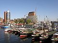
View over the Niederhafen to the Sandtorhöft, 2008

Decommissioned lightship and harbor cruise ship Anita Ehlers in the Brandenburg harbor, part of the lower harbor of Hamburg (2014)


literature
- Arnold Kludas , Dieter Maass, Susanne Sabisch: Port of Hamburg. The history of the Hamburg free port from the beginnings to the present , Hamburg 1988, ISBN 3-8225-0089-5 .
Web links
- Gert Kähler , Sandra Schürmann: Traces of History. Hamburg, its port and HafenCity. (PDF; 22.3 MB), publisher: HafenCity Hamburg GmbH, Hamburg 2010.
- Homepage City marina
Individual evidence
- ^ Franklin Kopitzsch , Daniel Tilgner (ed.): Hamburg Lexikon. 3rd, updated edition. Ellert & Richter, Hamburg 2005, ISBN 3-8319-0179-1 , p. 93.
- ↑ Hamburg.de: Overview Niederhafen (PDF; 4.8 MB), accessed on December 30, 2011