Advance
Vorsetzen is a street in Hamburg-Neustadt . It runs along the Elbe promenade of Hamburg's Niederhaven .
Description and course
Vorsetzen is located between the streets Johannisbollwerk and Baumwall , which it merges into at the Baumall of the same name . The approximately 330 meter long road has two lanes in both directions; the lanes are separated from each other by a median. On the median there are viaducts of the Hamburger Hochbahn , whose underground line 3 runs here between the Landungsbrücken and Baumwall stops . At 70 the road describes a bend. Between the two lanes there is a round bunker built in 1940 of the “Zombeck” type , which is now used as a restaurant. The Elbe promenade of the port of Hamburg runs parallel to Vorsetzen.
Origin of name
The name Vorsetzen was first mentioned in 1538. It is derived from oak planks that were placed in front of the bank as a sheet pile wall to protect against washout .
history

The building on the road and the oak planks in front of it are older than the name was first mentioned. Due to the design, ships could moor on the bank and be loaded or unloaded at this point. With the construction of the new fortifications in Hamburg, the Vorsetzen became part of the inner city. The Neustädter Neuer Weg , built in 1621 and connecting the Schaarmarkt with Vorsetzen, divided the street into the so-called “1. and 2. advance ”.
When in 1837 more space was to be gained for loading Ewern , the course of the Vorsetzen was widened by about 30 meters in the direction of the Elbe. In 1874/75 an iron driving bridge was built that ran parallel to the Roosenbrücke (later Rosenbrücke). Since the wooden structures had become dilapidated, they were renewed from 1889. At the same time, the street area was expanded again. The open spaces thus created could be used from 1910 for the construction of the viaducts of the Hamburger Hochbahn.
Sluice entrance house
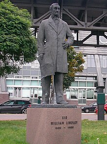
A so-called sluice-entry house is located on the heights of Baumwall , which was built in 1904 especially for a visit by Kaiser Wilhelm II to give him easy access to inspect the sewer system . It was not until 2012 that an associated underground dressing room was discovered during construction work, which the emperor should use to put on protective clothing for the sightseeing tour. The vault is three meters deep, has an area of approx. 6 m² and is equipped with glazed tiles. “ Hamburg Wasser ” had the historic room renovated with a sum of 28,000 euros. The public can visit the building annually on " Open Monument Day ". In honor of the first managing director of Hamburg City Drainage , the building was later named "Rainer-Funke-Entry". Next to the house is the monument to William Lindley , who was responsible for planning the Hamburg sewer system around 1842.
Round bunker
In 1940 a round bunker was built at number 70. From 1942 onwards, the historic perimeter development was largely destroyed.
Flood protection
For flood protection, the flood protection wall at the Niederhafen was raised and at the same time designed as an Elbe promenade , which continues parallel to the Johannisbollwerk . The design comes from the architect Zaha Hadid . Bright, curved stairs made of reinforced concrete lead to the street and the waterfront. The boulevard as flood protection has a height of up to 8.90 meters above sea level (above sea level). The lamps are designed based on ship masts. Emergency ladders are installed every 40 meters for climbing out of the Elbe.
Web links
Individual evidence
- ↑ Historical information on the tower: Vorsetzen 70 Homepage of the City of Hamburg. Retrieved November 13, 2014
- ^ Franklin Kopitzsch , Daniel Tilgner (ed.): Hamburg Lexikon. 4th, updated and expanded special edition. Ellert & Richter, Hamburg 2010, ISBN 978-3-8319-0373-3 , p. 733.
- ^ Franklin Kopitzsch, Daniel Tilgner (ed.): Hamburg Lexikon. 4th, updated and expanded special edition. Ellert & Richter, Hamburg 2010, ISBN 978-3-8319-0373-3 , pp. 733-734.
- ↑ Underground space: The secret room of Kaiser Wilhelm II. On Baumall , Hamburger Abendblatt from January 10, 2014
- ↑ Flood protection and promenade: New promenade on Baumall. In: Hamburger Abendblatt , May 4, 2019, p. 6.
- ^ Elisabeth Jessen: New Elbe Boulevard is ready. In: Hamburger Abendblatt , April 13, 2019, p. 9.
Coordinates: 53 ° 32 ′ 39.2 " N , 9 ° 58 ′ 41.6" E


