List of former city gates in Hamburg
This list of former city gates in Hamburg contains all former city gates of the Free and Hanseatic City of Hamburg as well as those of the former neighboring cities of Altona, Bergedorf and Harburg.

Overview
In the Hamburg city area, numerous streets, bridges, squares and (harbor) waters are named after earlier city gates . The large number results only to a small extent from the fact that today's Hamburg has grown together from several, once independent cities (Altona, Bergedorf, Harburg, Wandsbek), but mainly from the fact that the city was already in the Middle Ages and in the early days Modern times grew strongly and therefore had to adapt his city fortifications several times to the grown territory. Several development phases can be distinguished:
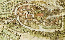
- The medieval city wall from the 13th century encompassed the present-day district of Hamburg-Altstadt and was provided with ten city gates (see adjacent illustration).
- This wall was strengthened in the 15th and 16th centuries by upstream ramparts ( Alter and Neuer Wall ) and moats; the existing gates were partially relocated, at least one gate (lower gate) was also completely closed.
- In the 17th century, under the direction of Johan van Valckenburgh, a new, significantly larger wall ring was built, which also included today's Neustadt and can still be seen in the city map on the course of Ring 1 . The number of gates was reduced to six for strategic military reasons. In addition, there was another fortress wall in front of the eastern suburb of St. Georg (the "New Plant") with two further gates. This fortification lasted until the beginning of the 19th century.
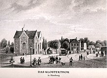
- After the end of the French era , the fortifications, which had become militarily obsolete, were removed and converted into parks. The old city gates were also torn down and replaced by modern new buildings, which were locked every evening until the gate was lifted in 1860. Additional exits (Ferdinand, Hafen, Holsten and Klostertor) have been created for the increasing traffic to the suburbs.
Well before the gates were well into the second half of the 19th century on the major arterial roads in addition the so-called (impact) trees - guarded passages that the control of persons and goods as well as the elevation of both Wegzolls served from which at that time the maintenance of the country roads was financed. Some of these trees have also been preserved in the form of street or district names, e.g. B. Eppendorfer Baum, Hammer Baum or Rother Baum .
Hamburg city gates
| Name / location | built | description | image |
|---|---|---|---|
|
Alstertor 53 ° 33 ′ 9 ″ N, 9 ° 59 ′ 51 ″ E |
13th century | Part of the medieval city wall as a connection from the horse market to the (inland) Alster, after the construction of the great wall ring became obsolete and only received as a street name | |
|
Berliner Tor 53 ° 33 ′ 13 ″ N, 10 ° 1 ′ 27 ″ E |
17th century | in the "New work" in front of St. George on the road to Hamm (hence probably also initially Hammer Gate today best known for the local high-rise complex) and on to Berlin, the Berliner Tor Center and the U- and S-Bahn station Berliner Tor | |
|
Brooktor 53 ° 32 ′ 39 ″ N, 9 ° 59 ′ 52 ″ E |
13th century? | already recorded on the oldest maps as " Brukdor ", originally on the bridge from Grimm to Grasbrook (Kornhausbrücke), later further south, giving the Brooktorkai and Brooktorhafen its name | |
|
Dammtor 53 ° 33 ′ 30 ″ N, 9 ° 59 ′ 21 ″ E |
13./17. Century | Originally located as Mölendor (Mühlentor) on Reesendamm across the Alster (hence the name as Damm-Tor), when the great Wallring was built in the 17th century, it was moved to the vicinity of today's Stephansplatz, where the streets Dammtordamm, Dammtorstraße and Dammtorwall are named and the Dammtor train station | |
|
Deichtor 53 ° 32 ′ 49 ″ N, 10 ° 0 ′ 8 ″ E |
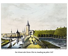
13./17. Century | as Winsertor already part of the medieval city wall as a connection to the city dike and Hammerbrook near the Elbe , originally probably located near the Meßberg , later relocated further to the south-west, giving its name to the Deichtorplatz and the Deichtorhallen | |
| Ellerntor 53 ° 33 ′ 1 ″ N, 9 ° 59 ′ 4 ″ E |
16th century | see Millerntor | |
|
Ferdinandstor 53 ° 33 ′ 23 ″ N, 10 ° 0 ′ 9 ″ E |
19th century | After the demolition of the Wallring around 1840, it was opened as an additional access ( excise gate) to St. Georg near the Alster instead of the former Ferdinandus bastion | |
|
Port gate 53 ° 32 ′ 44 ″ N, 9 ° 58 ′ 21 ″ E |
19th century | Opened after the razing of the Wallring around 1840 as an additional access to St. Pauli near the Elbe, today the name of a street east of the Landungsbrücken underground and S-Bahn station and, until 1920, this underground station as well | |
| Holsten Gate 53 ° 33 ′ 21 ″ N, 9 ° 58 ′ 39 ″ E |
19th century | Opened between 1853 and 1864 as an additional western exit between Damm- and Millerntor, today around Brahmsplatz / Sievekingsplatz, eponymous for the evening school there in front of the Holsten Gate | |
| Klostertor 53 ° 32 ′ 54 ″ N, 10 ° 0 ′ 23 ″ E |
19th century | Opened after 1840 as an additional eastern exit between Deich- and Steintor, named after the St. Johannis monastery , which was located on the monastery wall at the time , giving its name to the Klostertor train station there and the later Klostertor district | |
|
Lübecker Tor 53 ° 33 ′ 26 ″ N, 10 ° 1 ′ 14 ″ E |
17th century | in the “new factory” in front of St. Georg, the beginning of the road to Wandsbek and on to Lübeck, the Lübeckertordamm is a reminder of the former location | |
|
Millerntor 53 ° 32 ′ 59 ″ N, 9 ° 58 ′ 24 ″ E |
13./17. Century | (Milderdor, Mildradisdor, Diester- or Düstertor, Ellerntor, Altonaer Tor) originally on the corner of Rödingsmarkt / Graskeller, in the 15th and 16th centuries. Located near today's Ellerntorsbrücke , when the great Wallring was built in the 17th century, it was finally moved to the area known as it is today, where it is named for Millerntordamm, Millerntorplatz and Millerntor Stadium and the Millerntor underground station (today: St. Pauli ) | |
| Niederntor 53 ° 32 ′ 55 ″ N, 10 ° 0 ′ 17 ″ E |
13th century | (Nedderndor) in the medieval city wall at the end of Niedernstrasse , closed when the New Wall was built in the 16th century and only replaced by the monastery gate in the middle of the 19th century | |
|
Sandtor 53 ° 32 ′ 35 ″ N, 9 ° 59 ′ 24 ″ E |
16th century? | originally as Schaaltor around today's Brooksbrücke , later moved south to the Elbe island "Sand" (today Kehrwieder ), namesake for Sandtorhafen , Sandtorkai and Sandtorpark | |
| Scha (a) ltor 53 ° 32 ′ 41 ″ N, 9 ° 59 ′ 23 ″ E |
13th century | in the medieval city walls at the transition from Cremon to Grasbrookhafen unclear name origin, later by the southerly Sandtor replaced |

Brooksbrücke around 1587, behind the Schaaltor (with one tower), on the left edge of the picture the neighboring Schaartor (with two towers)
|
| Scha (a) rtor 53 ° 32 ′ 44 ″ N, 9 ° 59 ′ 2 ″ E |
13th century | Part of the medieval and early modern fortifications at the southern end of Rödingsmarkt and Alsterfleet , probably named after the Scharkapelle located there , named after Archbishop Ansgar , which became obsolete after the Neustadt was included in the Wallring, giving its name to the Schaartorbrücke and Schaartorschleuse | |
|
Sextuplets 53 ° 33 ′ 44 ″ N, 10 ° 0 ′ 54 ″ E |
19th century | Between 1853 and 1864 the exit near the Alster in the “New Plant” in front of St. Georg, originally also called “Alsterpforte” because of the location; The popular name Sechslingspforte stems from the fact that a private consortium charged a fee of 6 pfennigs here , not for the passage of the gate, but for the use of a path near the Alster to the newly developed Uhlenhorst - today the name of a path that runs parallel to the former wall Street |

The landmark of today's "Sechslingspforte" is the Alster swimming pool
|
| Spitaler Tor 53 ° 33 ′ 9 ″ N, 10 ° 0 ′ 15 ″ E |
13th century | Also Seekendor (Siechentor), part of the medieval city wall at the east end of Spitalerstraße and connection to the St. Georg Leprosy Hospital , closed in favor of the stone gate, which was moved to the north, when the large wall ring was built in the 17th century | |
|
Stone gate 53 ° 33 ′ 6 ″ N, 10 ° 0 ′ 21 ″ E |
13./17. Century | Also Sachsentor , already part of the medieval city wall, originally located at the east end of Steinstraße , moved to the north during the construction of the large wall ring in the 17th century (near Mönckebergstraße ), where the Steintorbrücke, Steintorplatz , Steintorwall and Steintorweg are named, east of the ZOB a former guardhouse from the early 19th century used as a restaurant. | |
| Winsertor | 13th century | see Deichtor |
City gates of the neighboring cities
Altona
Hamburg's western neighbor, Altona , has had no city fortifications and, accordingly, no (fortified) gates because of its “all too close” location (and corresponding Hamburg objections). The border to the neighboring suburb of Hamburger Berg (today's St. Pauli ) was described by Jonas Ludwig von Heß around 1800 as a simple ditch or “ gutter ”. Nevertheless, there were barriers on the main access roads to control the movement of people and goods, which were at least partially permanently blocked at night. From the banks of the Elbe to the north there were at least five such passages, also known as “gates” or “gates”, in the direction of Hamburg:
| Name / location | built | description | image |
|---|---|---|---|
| Pinnastor | at today's Pinnasberg ... | ||
| Jewish or butcher's door | Crossing Bachstraße (today Pepermölenbek ) / Langestraße | ||
| Drum gate | Crossing drum street / Bach street or today's street Pepermölenbek |

The only preserved cast-iron border post of the former Nobistor on the Reeperbahn .
|
|
| Nobistor | between Reeperbahn and Altonaer Reichenstraße , today Nobistor | ||
| Hummeltor | Paul-Roosen-Straße (between house numbers 5 & 8) |
Bergedorf
The Bergedorf , located on an island in the Bille , had no city wall since it was founded in 1275, but had two entrances to the west and east of the city.
| Name / location | built | description | image |
|---|---|---|---|
| Holsten Gate | 13th century | Older building on a small island west of the city, new building in 1601 on the banks of the Serrahn on today's Alte Holstenstrasse , demolished in 1816 and replaced by a wooden, later iron gate ( Hamey ), finally demolished in 1858 |
|
| Saxon Gate | 13th century | Initially also Heilig-Kreuz-Tor after a nearby chapel, after the Reformation then the Saxon Gate or Saxon Gate; . Original building while looking moat in the 18th century into disrepair and by an offshore when Hamey designated guardhouse (height Chrysanderstr.) Supplemented; 1846 demolition of the old gatehouse, 1857 also of the Hamey guard house |
Harburg
| Name / location | built | description | image |
|---|---|---|---|
|
Buxtehude Gate
(probably 53 ° 27 ′ 52 ″ N, 9 ° 58 ′ 46 ″ E ) |
|||
| Lueneburg Gate |
Wandsbek
Wandsbek had no gates in the strict sense, since the former estate village until the 19th century to the spots was in 1870 declared a town or. However, from 1838 to 1880 the customs border with Denmark and Prussia ran partly through the middle of Wandsbeck's urban area and was secured by a customs station on the road to Lübeck . The name Wandsbeker Zollstrasse reminds of this, as well as a plaque at the location of the former customs office.
swell
- Franklin Kopitzsch , Daniel Tilgner (Ed.): Hamburg Lexikon. 4th, updated and expanded special edition. Ellert & Richter, Hamburg 2010, ISBN 978-3-8319-0373-3 , p. 77 f. (Attachment) and 664 f. (City gates).
- Historical city views and city maps from 1320 , 1590 , 1810 , 1841 and 1880 .
- Chronoscope Hamburg - geo-rectified and interactive maps of Hamburg from the years 1590 to 1937.
Individual evidence
- ↑ a b The latest floor plan of Hamburg. Verlag BS Berendsohn, Hamburg 1853. In: www.christian-terstegge.de. Retrieved October 25, 2018 .
- ↑ a b c plan of Hamburg, Altona and the surrounding area. Verlag von BS Berendsohn, Hamburg 1864. In: www.christian-terstegge.de. 1864, Retrieved October 25, 2018 .
- ↑ From the Holstentor in Bergedorf. In: Lichtwark-Heft No. 40 (1977), pp. 2-13.
- ^ From the Sachsentor in Bergedorf. In: Lichtwark-Heft No. 41 (1978), pp. 13-24.


