
Ring 1 (Hamburg)
| Ring 1 | |||||||||||||||||||||||||
|---|---|---|---|---|---|---|---|---|---|---|---|---|---|---|---|---|---|---|---|---|---|---|---|---|---|
| map | |||||||||||||||||||||||||
 |
|||||||||||||||||||||||||
| Basic data | |||||||||||||||||||||||||
| Operator: | |||||||||||||||||||||||||
| Overall length: | 3.3 km | ||||||||||||||||||||||||
|
State : |
Hamburg |
||||||||||||||||||||||||
 |
|||||||||||||||||||||||||
|
Course of the road
|
|||||||||||||||||||||||||
The Ring 1 or Wallring is a ring-shaped road connection in Hamburg that runs on the inside of the Hamburg ramparts and surrounds the original core of the city. After the old city fortifications had been razed in the course of the 19th century, the streets were initially laid out as promenades and then made car - friendly after the Second World War . The originally planned crossing-free expansion was not implemented except for the Wallring tunnel, which was built in 1963–1966 .
The additional signage as Ring 1 has existed since 1970 and refers to the existence of two more approximately ring-shaped relief roads ( Ring 2 and Ring 3 ), which circumnavigate downtown Hamburg in concentric semicircles.
course
The ring was planned by Werner Hebebrand , who presented a sketch in 1956, after the Wallring was to become a largely intersection-free street that would lead through the city as an elevated road and be accessible via access ramps. Except for the Wallring Tunnel, which was built in 1963–1966, this was not built like this.
The following description is made here clockwise from west to east.
Holstenwall
Ring 1 begins at the Millerntordamm / Ludwig-Erhard-Straße intersection at the level of the Bismarck monument , where it branches off from the B4 . Here the ring runs on the Holstenwall , bounded to the west by the large ramparts or the Planten un Blomen park and the Museum of Hamburg History . To the east it passes the Hamburg Chamber of Crafts .
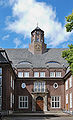
Museum of Hamburg History

Johannes-Brahms-Platz
It flows into Johannes-Brahms-Platz (formerly Holstenplatz, then Karl-Muck-Platz) with the Laeiszhalle and the Brahms Kontor , which served the Hamburg police headquarters from the 1950s to 1962.

Brahms office

Laeiszhalle


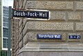
Gorch-Fock-Wall
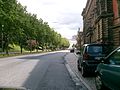
From here it runs on the Gorch-Fock-Wall (formerly Ringstraße , then Friedrich-Ebert- Straße ), flanked to the north by the small ramparts and the Old Botanical Garden .

Hygienic Institute on Gorch-Fock-Wall


Stephansplatz
The Gorch-Fock-Wall ends at Stephansplatz and to the east the Esplanade street continues to the Lombard Bridge . Dammtordamm runs from Theodor-Heuss-Platz, about 300 meters to the north, with the Hamburg-Dammtor long-distance train station , to Stephansplatz and from there continues as Dammtorstraße in the direction of Gänsemarkt .
At the south-western corner of the intersection , under which the subway station of the same name on the U1 line is located, is the building complex of the Alte Oberpostdirektion . The Colonnaden , a pedestrian zone that begins not far from the Esplanade , leads to the Neuer Jungfernstieg on the west bank of the Inner Alster .


Esplanade
In the further course the ring runs over the Esplanade with the former Casino Esplanade of the Spielbank Hamburg in a former Grand Hotel. This is followed by the Burmah Oil high-rise and the striking Finland building . On the right side of the esplanade there are office and office buildings, hotels and remnants of the originally classicist residential development. At the corner of the Neuer Jungfernstieg stands the former Esso-Haus, which later housed the Hamburg World Economic Archives. The street itself has a separate lane to the north in the middle, laid out as an avenue.

Casino Esplanade


Lombard Bridge
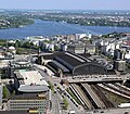
As an extension of the Esplanade, the ring runs on the Lombard Bridge , which runs just a few meters next to each other parallel to the railway bridge of the connecting line and the Kennedy Bridge (formerly New Lombard Bridge ) over the connection of the Inner Alster, which borders to the south, and the Outer Alster, which borders to the north. It crosses the 10th east meridian .


Wallring tunnel
Behind the bridge follows the Wallring tunnel or, alternatively, the streets Glockengießerwall , Steintorwall and Klosterwall , which run exactly over the tunnel, but allow you to turn into side streets. To the east, these are bordered by the Hamburger Kunsthalle and Hamburg Hauptbahnhof . To the west of the streets is the city center and pedestrian zone of Hamburg with the shopping streets Spitalerstraße and Mönckebergstraße . In the further course, the street is now lined with a large electronics store (previously a Horten department store). The Natural History Museum, which was destroyed in the Second World War, and the Schweinemarkt bathing establishment, which was demolished around 1955, stood at this point . The southern end of the building was the City-Hof complex, which was demolished in 2020 .

Wallring tunnel south portal before the renovation


Deichtorplatz

At the east end of the street, the tunnel and the streets above it meet Deichtorplatz . This represents the eastern end of the ring. Here it meets the B4 again, which at this point is called Willy-Brandt-Straße to the west and Amsinckstraße to the east .
literature
- Sven Bardua, Gert Kähler : The city and the car. How traffic changed Hamburg (series of publications by the Hamburg Architecture Archive), Dölling and Galitz Hamburg 2012, ISBN 978-3-86218-030-1 , p. 48 ff.