
Hamburg-HafenCity
|
district of Hamburg |
|
|---|---|
  |
|
| Coordinates | 53 ° 32 '30 " N , 9 ° 59' 36" E |
| height | 8 m above sea level NN |
| surface | 2.4 km² |
| Residents | 4925 (Dec. 31, 2019) |
| Population density | 2052 inhabitants / km² |
| Post Code | 20457 |
| prefix | 040 |
| district | Hamburg-Mitte district |
| Transport links | |
| Federal road |
|
| Subway |
|
| Train |
|
| bus |
6th
111
256
|
| Source: Statistical Office for Hamburg and Schleswig-Holstein | |


The HafenCity (also HafenCity ) is a district in Hamburg-Mitte of the Free and Hanseatic City of Hamburg . It consists of the area of the Großer Grasbrook , the northern part of the former Elbe island Grasbrook , and the Speicherstadt on the former Elbe islands Kehrwieder and Wandrahm and was officially founded in 2008. It borders in the north, separated by the Zollkanal , on the Hamburg city center , in the west and south on the Elbe and in the east, bounded by the Oberhafen, on Hammerbrook and Rothenburgsort . The district is completely surrounded by rivers and canals and has a total area of around 2.2 square kilometers.
In a narrower sense, HafenCity is the project name for the approximately 157 hectare area on the Großer Grasbrook, which was formerly part of the free port . By the beginning of the 2030s, residential units for up to 14,000 people, up to 3,000 hotel rooms and workplaces for up to 45,000 people, primarily in the office and service sector, are to be created on the site. In addition, it is calculated with up to 10,000 schoolchildren and students as well as around 50,000 customers and tourists per day, so that after completion, over 120,000 people should animate the district every day. It is currently one of the largest inner-city urban development projects in Europe.
Preliminary work
The groundbreaking ceremony took place on April 9, 2001, the first foundation stone was laid on June 20, 2001. In 2009, the first part of HafenCity was completed with the Am Dalmannkai / Sandtorkai sub-district . According to HafenCity Hamburg GmbH , which is responsible for the development and marketing of HafenCity, half of the construction volume on which the master plan is based has already been realized, is under construction or in preparation.
Demarcation
HafenCity district

On March 1, 2008, HafenCity was declared a separate Hamburg district by the law on the spatial structure of the Free and Hanseatic City of Hamburg (RäumGlG). It consists of the former port areas of the Großer Grasbrook and the Speicherstadt on the former islands of Kehrwieder and Wandrahm and thus includes separate areas of the adjacent districts of Old Town , Rothenburgsort and the Klostertor district, which was dissolved together with the founding of the HafenCity district . The exact delimitation of the two districts of the new district took place on February 20, 2007 by ordinance of the Senate . Five years earlier, on January 1, 2003, the area was released from the duty-free zone of the Hamburg free port , which existed until 2012 , in order to enable residential development and the creation of the corresponding infrastructure.
Speicherstadt
Due to the new structure, the Speicherstadt is no longer part of Hamburg's old town under administrative law, but forms the northern area of the HafenCity district. Nevertheless, the term HafenCity is commonly understood to mean the former port area that is the focus of urban development and the Speicherstadt is viewed as an independent quarter.
history

The site of the former Grasbrook island, on which HafenCity is being built, was outside the city gates until the beginning of the 19th century. The city fortifications ran roughly along today's street Am Sandtorkai . The residential areas of Kehrwieder and Wandrahm were located within the walls, in the area of today's warehouse district . In front of the city wall, marshy meadows served as pastureland, the western tip of the Großer Grasbrook was used as a place of execution in the 15th century , the execution of the pirate Klaus Störtebeker and the Vitalienbrüder is particularly well known . In the 18th and early 19th centuries shipbuilders and port trades settled here. In 1844 the first Hamburg gas plant was built in the northern part of the island .
As in the 19th century, the capacity of the port with domestic and Niederhafen not sufficient more, the areas offered themselves to lay down their walls of Grasbrook as port expansion area on. In 1868 the first artificial harbor basin was the Sandtorhafen , and in 1881 the Grasbrookhafen was added. This was followed by the Strandhafen directly on the Norderelbe, the Magdeburger Hafen with Brooktorhafen and Ericusgraben as a connection to the Oberhafen and finally the Baakenhafen with the railway system to the Elbe bridges and the Kirchenpauerhafen with an anchorage in the Elbe. The entire island was built on with harbor basins and facilities until 1886, and in 1872 the Hanover station was opened at Lohseplatz , east of Magdeburg harbor . The exposed building was the first Kaispeicher A at Sandtorhöft, also completed in 1872 .
The residential districts of Kehrwieder and Wandrahm were cleared and demolished from 1883 onwards for the establishment of the customs and duty-free area of the free port , and around twenty thousand people were relocated. The Speicherstadt was inaugurated at this point as early as 1888 . At the Magdeburg harbor , the Kaispeicher B was built in 1878 and the administration building of the port authority in 1885 . At the turn of the century, the first heated fruit sheds were set up opposite, and in 1928 a herring cold store designed by Fritz Schumacher was set up on the Hübnerkai .
After the massive war damage and reconstruction, general cargo handling continued to grow from 1955, and the first RoRo ship in Hamburg was unloaded at the Sandtorhafen in the early 1960s . But the docks, which were almost a hundred years old at the time, were unsuitable for further modernization. From the mid-1960s, the active port areas for the growing container handling and the ever larger ships were relocated downstream of the Elbe, west of the Old Elbe Tunnel , the areas of the Großer Grasbrook became more and more industrial wasteland. Until 2001, Cellpap was one of the last companies to operate a large terminal on Strandkai , which supplied the Hamburg printing industry with paper , and a coffee warehouse remained nearby. Both were relocated and demolished in October 2002, so that nothing stood in the way of building the entire area. The proceeds from the sale of the city's own land refinanced a loan for the development of the Altenwerder container port in the amount of more than 500 million euros.
Planning the HafenCity
Role models and basic considerations
The earliest and possibly most prominent example of the conversion of former port areas are the Docklands in London. Significant reconstructions of waterfront zones have been found in many large port cities over the last few decades. The reason for this was the development of container handling . In Hamburg, the arrival of ships with ever greater drafts could be countered by dredging the river bed of the Elbe, but the St. Pauli Elbe Tunnel , which went into operation in 1911 , has two tubes at a depth of around twelve meters below the level of the mean flood became a barrier to further expansion of the eastern port area. The expansion of the port facilities was and is therefore concentrated on the expansion of capacities in the western part of the port. However, due to the location of the fallow land close to the city center , this restriction could be seen as an opportunity for urban development.
Political preparation for HafenCity in 1997
The first plans for the development of the Großer Grasbrook were developed in the early 1990s. These were politically concretized and resolved in a few months in 1997:
- On May 7, 1997, the then Mayor of Hamburg, Henning Voscherau, announced the plans for the complete redevelopment of Grasbrook for the first time in a lecture at the Übersee-Club and presented a feasibility study.
- On May 20, 1997, the Senate's official notice to the citizens appeared , with which the committees were informed about the plans. The historical significance of the place where the port of Hamburg was expanded in the 19th century was emphasized. In this tradition, “the future should be shaped from the experiences of the past”.
- After a Senate rally with the Mayor's speech at the Mayor's meeting on May 21, 1997, the project was discussed controversially among the citizens. In particular, the fact that the construction of the Altenwerder container terminal (CTA) was to be financed through the sale of the urban land in the planned new development area aroused opposition .
- On August 18, 1997, the urban development committee discussed "Hamburg's location and port development in the 21st century" and the related financing of the port expansion in Altenwerder. On August 19, 1997, the then opposition CDU parliamentary group submitted a motion entitled, which basically supports further planning taking into account the financial possibilities, but wants to postpone a decision to the next legislative period.
- On August 20, 1997, the Hamburg citizenship decided at the 101st meeting to set up a Hafencity (still in this spelling) on the Großer Grasbrook. This date is considered to be the starting signal for the development of the new urban area.
Development plans for HafenCity
After an urban development competition, the HafenCity master plan was published in 2000 as the urban development concept for converting the edge of the port into an extension of Hamburg's inner city. The master plan explains that HafenCity follows an economic, social, cultural and urban ecological objective. It was recognized as a particular problem that a completely new urban district must be widely accepted at an early stage. In addition to the international urban development competition, a public planning dialogue was therefore also planned.


The official planning and the development plans under administrative law have been established step by step and area-related since 2004:
- Hamburg-Altstadt 31 , established on June 9, 1992: five years before Henning Voscherau's speech to the Übersee-Club, the Hanseatic Trade Center was made possible in planning at the entrance of today's HafenCity by moving the free port border around the area of the property to the Speicherstadt has been. This project was already discussed controversially in the city. However, the Hanseatic Trade Center is not part of the HafenCity project.
- Hamburg-Altstadt 32 / HafenCity 1 , determined on November 3, 2004: Determination of the new buildings on Sandtorkai and Dalmannkai, originally the conversion of the Kaispeicher A for a so-called MediaCityPort was planned.
- Hamburg-Altstadt 34 / HafenCity 2 , determined on December 4, 2007: Determination of the new Brooktorkai building , the former customs areas are to become the hotel and office location, e.g. B. for Germanischer Lloyd .
- HafenCity 3 , determined on December 4, 2007: Planning of the new development at Sandtorpark , the site of the former coffee warehouse east of the Sandtorhafen. Offices and apartments, a school and a park are to be built. In addition, new road traffic areas were identified. The public display of the development plan was from July 10, 2007 to July 27, 2007.
- Hamburg-Altstadt 36 / HafenCity 4 , determined on April 24, 2007: This development plan replaces part of the Hamburg-Altstadt 32 / HafenCity 1 plan ; instead of the MediaCityPort, the conversion and addition of the Kaispeicher A to the Elbphilharmonie was determined.
- Hamburg-Altstadt 39 / HafenCity 5 , established on February 19, 2008: this plan deals with the area west of the Magdeburg harbor, which is to be developed into the Überseequartier as the center of HafenCity. In particular, offices, retail, multi-storey apartments, restaurants, facilities for science, culture and leisure, as well as a cruise terminal with two berths and the facilities for handling are planned. In addition, inner-city open spaces are to be created. The public display of the development plan was in November / December 2006.
- HafenCity 6 : Construction of the HafenCity University south of Versmannstrasse in the corner area of Magdeburger Hafen and Baakenhafen. Further office buildings and publicly accessible promenades on the east bank of Magdeburg harbor and the north bank of Baakenhafen are to be created. The public display of the development plan was in November 2007.
- HafenCity 7 : On Strandkai , the new Unilever house was identified on a former power plant site. The planning area includes the headland between Grasbrookhafen and Norderelbe and the area east of the headland up to San-Francisco-Straße. The realization of a mixed-use quarter on the headland between Grasbrookhafen and Norderelbe and on areas east of the headland was also decided; further offices and apartment buildings as well as inner-city open spaces, restaurants and other services are to be created. The public display took place in the summer of 2007.
- HafenCity 8 : deals with the Ericus peninsula east of the Poggenmühle street and south of the Oberbaumbrücke street , it deals with the realization of the new Spiegel publishing house . The quay zones at Ericusgraben and Oberhafen are to be created as publicly accessible promenades. The public display of the development plan was in May 2008.
- HafenCity 9 , Magdeburger Hafen / Shanghaiallee (Hamburg-Mitte): Mixed-use district between Magdeburger Hafen and Shanghaiallee
- HafenCity 10 , east of Shanghaiallee (Hamburg-Mitte): mixed-use area around Lohsepark
- HafenCity 11 , western and central Baakenhafen (Hamburg-Mitte): Mixed-use area including elementary school around the western and central Baakenhafen
- HafenCity 12 , Speicherstadt (Hamburg-Mitte): Development of the Speicherstadt and protection of the Speicherstadt as a listed ensemble.
Public planning dialogue
The diverse experiences with the difficulties of drawing board cities to find acceptance and thus social and cultural integration into existing city structures were already mentioned in the master plan. That is why a concept of information and cultural presentations in the middle of the large construction site was created before the start of development.
HafenCity InfoCenter in the boiler house

In 2000, the HafenCity InfoCenter, an exhibition and documentation center dedicated to the HafenCity project, was set up in the old boiler house of the Speicherstadt in the street Am Sandtorkai . The core of the information center is an urban model on a scale of 1: 500 that depicts the current planning status of the project. At so-called knowledge stations , visitors receive audio-visual information about HafenCity and related topics such as the history of large port cities or flood protection.
The building was only given a new function from 1888 as an information center for HafenCity. In 1999, HHLA commissioned the architectural office GMP ( Gerkan, Marg and Partner ) to design the architectural design for the information center ; the exhibition concept was developed in collaboration with the Andreas Heller studio. On December 6th, 2000 the opening took place by the First Mayor Ortwin Runde . In memory of the old function as a boiler house, the chimneys destroyed in the war have been modeled since April 2001 with two 20-meter-high steel mesh structures, which means that the information center is widely visible.
ViewPoint and other insights


In addition to comprehensive information, both through models and through numerous brochures and series of publications that appear regularly, the entire construction area is accessible with footpaths adapted to the construction sites, construction fences are kept open and informative insight is provided at changing locations. In 2004, a thirteen-meter-high observation tower, the so-called ViewPoint, was erected on the banks of the Großer Grasbrook to give interested parties an insight into the construction site. In 2007 it was moved a hundred meters to the north as the development of the development of the Strandkai had advanced. Since August 2013 the ViewPoint has been located at Baakenhafen, directly at the southern end of the Baakenhafenbrücke, in order to be able to observe the construction process there.
Another viewing platform was set up at the corner of Shanghaiallee and Versmannstrasse, from which it was possible to take a look at the construction site of the HafenCity University subway station on the U4 line during the construction period from 2007 to 2012 .
Information pavilions
In summer 2008, the InfoPavilion on Osakaallee was the first building in Überseequartier to be completed. It serves as the central information point for the development of the quarter and has an exhibition area of around 170 square meters.
Also in the summer of 2008, a pavilion was opened on the Magellan Terraces, which deals specifically with the Elbphilharmonie project. The acoustic model of the great hall of the Philharmonie is exhibited inside the pavilion, while sound and video installations give an impression of the later concert operation on the outside .
Exhibitions outside of HafenCity also drew attention to individual projects, for example the former public reading hall at Mönckebergbrunnen was set up as a culture café in July 2009 as an information service by the Elbphilharmonie in order to create “the right atmosphere for conveying Hamburg's music and cultural highlights”. The controversial construction of the underground line to HafenCity was also advertised with an information pavilion on Jungfernstieg .
Criticism of the HafenCity project
Allocation practice of the land
The practice of using the proceeds from the sale of land to finance the Altenwerder container terminal was already criticized during the planning stage. The fear was that due to the importance of the terminal for the Hamburg economy there would be increased selling pressure on the city and the city would be tempted to weight the profitability of a sale higher than the quality of the submitted usage concept for a property. In addition, the city increased the number of building plots in the course of the planning process, but declared this step unilaterally with the urban planning consideration that a higher and more urban building density should be achieved if the actual land or another relevant reason increases the number of those for sale to be offered land and thus the revenue opportunities.
Social structure
There are fears that the housing supply is aimed one-sidedly at customers from the upper income bracket. This is offset by the efforts of some cooperatives that offer rents in the middle segment, but their share in the total housing mass has so far been extremely low. With the ongoing expansion of HafenCity and the influx of further population groups, the social structure of HafenCity is approaching the Hamburg average. In 2013, 51.9% of the 1,834 residents were employed subject to social security contributions (Hamburg average: 53.4%), 1.6% were unemployed (Hamburg: 5.6%), and only 0.2% gave in to benefit recipients SGB II (so-called Hartz IV recipients ) (Hamburg average 10.2%). The proportion of people under the age of 18 is 11.1% (Hamburg: 15.6%) and the proportion of those over 65 is 10.5% (Hamburg: 18.8%). The average apartment size is 93.3 m² (total Hamburg 74.9 m²) and the living space per person is 52.7 m² (Hamburg average 39.2 m²).
architecture

Furthermore, the architecture and urban structure are criticized: the solitary character and the lack of fragmentation of the vast majority of the buildings realized so far stand in direct contrast to both the adjacent Speicherstadt and most of the inner city, the development of which is determined by more urban block edge structures . The architecture of the HafenCity buildings is sometimes described as banal, cold, interchangeable, fashionable instead of timeless and uninspired. The long-time Mayor of Hamburg Henning Voscherau , for example, was critical of the public . Proponents oppose this statement by stating that the overall impact of HafenCity can only be conclusively assessed once it has been completed.
environmental issues
The residents of the Hafencity are confronted with two environmental problems: The cruise ships moored in the immediate vicinity produce considerable exhaust gases with fine dust and nitrogen oxides when they generate their electricity with the ship's engines while they are berthed. Only AIDA Cruises ships can be supplied at the terminal from a barge on which electricity is generated from liquefied natural gas.
In the early days, the facades of Hafencity were regularly visited by so-called bridge spiders, who love moisture and, due to the lack of sufficient greenery in the Hafencity area, had no predators. The spider webs and the remaining chitin shells of the prey contributed to the nuisance of the residents. Now this phenomenon can only be observed periodically.
Construction of the HafenCity
According to the plans, the construction of HafenCity is divided into ten so-called quarters , which are to be realized from west to east and from north to south. The entire construction area stretches north from Sandtorhöft over Sandtorkai and Brooktorkai along the Speicherstadt to the Oberhafenbrücke, over the Oberhafen and Billhafen to the Elbbrücken; and south of Sandtorhöft to the Elbe bridges along the Norderelbe. The adjacent Speicherstadt, which together with the new development area has formed the HafenCity district since 2008 , is subject to a further urban planning program.
At the Sandtorkai / Dalmannkai

At the Sandtorkai
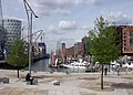
Am Sandtorkai is the first HafenCity district to be built and corresponds to the Hamburg-Altstadt 32 / HafenCity 1 development plan . It is located at the Sandtorhafen, the formerly first modern harbor basin of the tidal harbor, which was built in 1866, in the immediate vicinity of the Speicherstadt to the south. The quarter consists of five residential and three office buildings with around 38,000 square meters of gross floor area (GFA). It has been considered completed since 2005. Users include the China Shipping Europe headquarters . Some houses have been given names with a maritime reference: Ocean's End , H2O , Dock 4 (in which the first inhabitant of HafenCity moved in December 2004) and Harbor Cube .
The traditional ship harbor was opened in the old harbor basin in September 2008 , in which a spacious floating pontoon serves as a pier for historic ships. The former Sandtorkai was provided with a promenade below the overhanging buildings. The Am Sandtorkai district is to form an urban ensemble together with the Dalmannkai and Am Sandtorpark - Grasbrook districts .
Sandtorhafen at the port birthday in May 2009, view over the Magellan Terraces

Sandtorfleet in HafenCity with a pontoon and a view of the Sandtorkai


Dalmannkai

With the Dalmannkai section , the second part of the quarter was built on the headland between the Sandtorhafen and the former Grasbrookhafen, also according to the Hamburg-Altstadt 32 / HafenCity 1 development plan and the Hamburg-Altstadt 36 / HafenCity 4 change plan. On a gross floor area (GFA) totaling 115,000 m², service areas, offices, retail stores and both condominiums and rental apartments have been created. The first apartments were ready for occupancy in the summer of 2006, the first shops opened in the summer of 2007, and since August 2009 the entire quarter has been considered completed. This construction phase also includes the promenades and the waterfront places Magellan-Terrassen at Sandtorhafen, Vasco-da-Gama-Platz , Dalmannkaitreppen and Marco-Polo-Terrassen at Grasbrookhafen.
Structural features:
- Elbphilharmonie in a prominent location on Sandtorhöft , includes two concert halls, a five-star hotel and 47 condominiums as well as a public, covered plaza at a height of 37 meters
- Diakonische Martha-Stiftung : Seniors' apartments, partly owned, partly for rent
- Oval residential tower on Kaiserkai and office on Kaiserkai, Ingenhoven Architekten GmbH, Düsseldorf
- Building cooperative Bergedorf-Bille , 42 cooperative apartments, architect: Prof. Jörg Friedrich
- Am Kaiserkai 23–33 : Mixed building with rental apartments from five different Hamburg building cooperatives and additional condominiums, three architects' offices were also involved.
At Sandtorpark / Grasbrook

The Am Sandtorpark / Grasbrook district is to the east of the Sandtorkai and Dalmannkai districts , across the Großer Grasbrook street . The new thermal power station on Dalmannkai and the office buildings from SAP , 2003, and Kuehne + Nagel , 2006, were the first buildings in the southern part of the area, formerly the property of the Hamburg gas company , later Hamburgische Electricitäts-Werke (HEW).
The NHL Hinsch & Cons coffee roasting and storage facility was located on the neighboring northern property until 2006 . , owned by the Neumann Kaffee Gruppe . It had a right of use until 2013, but was disadvantageous for the further development of HafenCity, primarily due to the production-related odor nuisance. She was offered an alternative plot of land on the Hohen Schaar in Wilhelmsburg at favorable conditions , and she was also given the opportunity to build a new business center on site. The warehouse was demolished immediately and the new buildings were partially completed in 2009.
The district will be determined by the Sandtorpark , a central green area around which the individual buildings are grouped. The completion of the parking area and the entire quarter should take place in early 2011.
Structural features:
- Katharinenschule an all-day primary school with a day-care center, in operation since August 2009. The school yard is laid out on the roof of the building. The school emerged from the closure and relocation of the former primary school near Sankt Katharinen from the old town.
- Skaì , office building with catering opposite the Magallan Terraces , completed in November 2009
- Hamburg-Amerika-Center , office building, completed in 2009
- International Coffee Plaza of the Neumann Group, completion 2010
- the Baugemeinschaft Hafenliebe , family-friendly residential development, residential projects with small commercial units, completed in early 2011
- Outdoor exercise course in the eastern Grasbrookpark, completed August 2013
Strandkai

According to the Hamburg-Altstadt 41 / HafenCity 7 development plan, the Strandkai district includes the former beach port on the Norderelbe and the Hübnerkai on Grasbrookhafen as well as the areas south of the Sandtorpark district facing the Elbe. Because of the environmental pollution from the neighboring cruise terminal, there should be no residential development in the eastern area. Service, catering and leisure facilities are planned, the implementation of which was postponed until 2011 due to the construction of the underground line. In the western part and towards the Strandhöft, exclusive residential complexes are to be built and completed in 2021. The overall structure is dominated by high buildings with towers up to 60 meters high.
Already completed:
- The Unilever head office , Behnisch Architekten, Stuttgart, with a publicly accessible atrium and terraces facing the Elbe, completed in September 2009
- Marco-Polo-Tower , Behnisch Architekten, Stuttgart, 17-story residential tower with 58 exclusive apartments, the shell was completed in August 2009
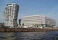
Marco Polo Tower and Unilever House
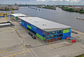
Temporary Hamburg Cruise Center HafenCity , Großer Grasbrook / Chicagokai

Marco-Polo-Terrassen with a view over the undeveloped Strandkai and the Elbe to the Kleiner Grasbrook, on the left the construction site of the Marco-Polo-Tower, May 2008


Überseequartier

The Überseequartier is planned as a central part of the HafenCity; in terms of planning law, it is covered by the development plan Hamburg-Altstadt 39 / HafenCity 5 . It lies west of the Magdeburg harbor and extends from the Sandtorkai road to the banks of the Norderelbe and is divided into a northern and a southern part by the Übersee-Allee, which runs in an east-west direction . The Überseeboulevard street will be the central element of urban planning and will run through the entire length of the district from north to south.
Around 275,000 square meters of gross floor area (GFA) are to be realized in the quarter's 14 construction projects. The usage concept developed uniformly for the quarter provides for retail and catering on the ground and first floors along the Überseeboulevard . The northern part of the quarter will mainly be characterized by residential use, while the southern part will be mainly characterized by office use. The individual construction projects are named after historically valuable commercial goods; Sumatra or Sumatrakontor , Java and Virginia ( tobacco ), Arabica and Pacamara ( coffee ), Ceylon ( tea ), Cinnamon ( spices ), Silk ( textiles ) and rosewood ( precious woods ). Prominent individual projects are also a cruise terminal with an attached hotel and the Waterfront Towers . An originally planned science center will no longer be realized according to current plans. The old port authority from 1872 is the only existing building to be preserved and converted into a market hall with a residential high-rise.

The quarter was developed in two stages, construction of the northern part up to Überseeallee started in 2007 with completion and first occupancy in 2010. After that, work on the southern part began. Since the end of 2012, the new U4 underground line has opened up the area with the Überseequartier underground station .
Brooktorkai / Ericus

The Brooktorkai district is located on the area between Brooktorhafen and Brooktorkai Street, begins in the west at the intersection of Osakaallee and stretches east to Ericusspitze. It corresponds to the development plans Hamburg-Altstadt 34 / HafenCity 2 and HafenCity 8 . The Ericus bastion of the former city fortifications from the 17th century can still be seen on the base of the Ericusspitze . Until 2002, the area was mainly used by the Brooktorkai customs office. Due to its direct location in the vicinity of the Speicherstadt and the walking distance to Hamburg Central Station, this quarter was advertised as a preferred location. The construction projects have been implemented since 2006:
- Germanischer Lloyd , office and boarding house with 53,000 m² of gross floor area (GFA) on four building plots, architects: Gerkan, Marg and Partner, Jan Störmer Architekten (office), Antonio Citterio and Partners (boarding house), completion in early 2010

- Building of the Spiegel Group Ericusspitze, 30,000 square meters GFA, Henning Larsen Architects Copenhagen, construction between 2008 and 2011. The Hamburg editorial offices of Der Spiegel , Spiegel TV , Spiegel Online and Manager Magazin have been brought together here.
- Ericus-Contor with 20,000 m² GFA, Henning Larsen Architects Copenhagen, completion 2011
- The Shanghai Bridge connects the two banks of Brooktorhafen, completed in 2006
Elbtorquartier

The Elbtorquartier is designated with the HafenCity 6 development plan. It is located east of the Magdeburg harbor between Brooktorhafen and the mouth area of the Baakenhafen in the North Elbe, to the east there is the Shanghai-Allee to Quartier Lohseplatz demarcated. The area was occupied in particular with collecting sheds for sorting goods before onward transport. As part of the HafenCity planning, it was managed as a quarter under the name Magdeburger Hafen until 2009 .
The outstanding project is the construction of the HafenCity University (HCU) between Übersee-Allee and Baakenhafen. Here, the departments of architecture , civil engineering , geomatics and urban planning , which were previously distributed in the urban area, are combined in one building. Construction started at the end of 2009.
Between 2013 and 2014 the Elbarkaden with the Greenpeace Germany headquarters, desigxnport hamburg and around 90 apartments were completed. The defining element for the appearance of the building is the city loggia that opens towards the water .
Further Elbtorquartier projects are still in the planning stage:
- Stadthaushotel as an integrative hotel for people with disabilities, sponsored by the association jugend hilft jugend e. V.
- Ecumenical Forum Bridge in which a total of 21 Christian churches carry out a community project, consisting of a chapel , a foyer with information offerings, seminar rooms and a café. (A temporary chapel of around 50 m² in size on the Großer Grasbrook has been open to visitors since 2008.) The Brücke - Ökumenisches Forum HafenCity association consists of the Evangelical Lutheran Church , the Roman Catholic Church , the Old Catholic Church of the Evangelical Reformed Church , Protestant free churches such as the Baptists and Mennonites and congregations of the Anglican and several Orthodox churches

The preserved storage structures at the Magdeburger Hafen / Brooktorhafen transition area have already been completed:
- The Kaispeicher B , oldest existing memory from 1879, has been completely refurbished and since the summer of 2008 with the Maritime Museum occupies
- Gebrüder Heinemann , storage building in the immediate vicinity of Kaispeicher B from 1978, was converted into the company's headquarters in 2008
The public space is to be created in particular through the already completed museum bridge over the Brooktorhafen (architect: Dietmar Feichtinger , engineers: WTM Engineers) and the passage through Kaispeicher B to the museum square with the as yet unrealized promenade at the, designed by the Catalan architect Beth Galí Magdeburg harbor to be determined.
At the Lohsepark

The Am Lohsepark district is located east of the Elbtor district between Shanghaiallee and the railway line that leads to the Elbe bridges, and also stretches from Brooktorhafen to Baakenhafen. This area was dominated by the Hanover station on Lohseplatz, which served as a port freight station until 1955. To the west of Lohseplatz was the hard rubber factory of the entrepreneur Heinrich Christian Meyer , in which walking sticks were manufactured in particular. The entrepreneur, considered a pioneer of industrialization in Hamburg, was often called Stockmeyer , which is why the adjacent street got its name. The factory buildings have been preserved as a renovated historical ensemble; since April 2008 it has housed the private prototype car collection , the Funk und TV Akademie Hamburg GmbH and, for the time being, the headquarters of the HafenCity University (HCU).
The entire rest of the area is in the planning stage. In particular, a 3.5 hectare park, the Lohsepark , is planned on this area . A memorial for the more than 8,000 people who were deported from the Hanover train station to concentration and extermination camps between 1940 and 1945 is to be integrated . This place, in the middle of the port industry and yet close to the city, became a pragmatic meeting place during the National Socialism. The first action was carried out on May 16, 1940, criminal police detachments arrested around 550 Sinti and Roma in Hamburg, as well as another 200 people from Schleswig-Holstein and 160 people from Bremen. They were interned for four days in fruit shed 10 at the nearby Magdeburg harbor. On May 20, 1940, they were deported from the port station to the Bełżec extermination camp in south-east Poland. In the following years, at least twenty deportation trains left here, with which 7,112 Jews, Roma and Sinti were deported to the Theresienstadt concentration camp , the Litzmannstadt ghetto , the Minsk ghetto , the Riga ghetto and the Auschwitz camps.
After this place was forgotten for years in the post-war period, at the latest after the Hanover train station was demolished in 1955, it has been included in the HafenCity construction projects since 2008, following the intervention of various institutions. The “denk.mal Hannoverscher Bahnhof” memorial site and an exhibition space are being built on the site, which is being designed as Lohsepark .

The Lohseplatz with the memorial plaque in 2007

The Lohseplatz with the memorial plaque in 2013


Oberhafen

The district between the railway line and the Oberhafen is to be created with a link to Hamburg's cultural mile at the Deichtorhallen . In addition, some sports and tennis courts are being planned here.
Baakenhafen

Subdivided into a northern and a southern area, which is mainly advertised for residential development. The quarter is located at the Baakenhafen of the same name and also forms the southern border of HafenCity.
Elbe Bridge Center

The Elbbrückenzentrum district is to be built with “small skyscrapers” of 16 to 26 floors in the eastern Baakenhafen near the Elbbrücken. Amerigo-Vespucci-Platz will form the central square of the quarter. The district is connected to public transport with the Elbbrücken underground station and the Elbbrücken S-Bahn station, which is currently under construction .
In March 2017, Mayor Olaf Scholz and Chief Construction Director Jörn Walter presented plans for the “Elbtower” project directly on the Elbe bridges. Construction work on the up to 200 m high skyscraper is to begin in 2020 if private financing is secured.
Transport links
Transportation

Until December 2012, HafenCity was connected to the city center with three local public transport buses . These were completely or partially withdrawn and the new bus route 111 to St. Pauli and Altona was set up.
The first section of the underground line ( line U4 ), which has been built since 2007 , was opened to traffic on November 29, 2012. It strengthens operations on the eastern section of the U2 line between Billstedt and Jungfernstieg . The new U4 line begins at Jungfernstieg. The two tunnel tubes initially lead in a north-west direction from the existing train station, describe a large curve through the Neustadt (albeit without stops) and reach HafenCity from the west past the Elbphilharmonie. Two tunnel stations were built here, the Überseequartier and HafenCity University subway stations . The extension to the Elbbrücken station was opened on December 6, 2018. There are considerations for a further extension to the south towards Wilhelmsburg. Alternative suggestions for an above-ground route were rejected as structurally and operationally unsuitable. The planned connection by a much cheaper light rail was also rejected after the Hamburg state government changed. In the vicinity of HafenCity and Speicherstadt are the subway stations Baumwall on the U3 line and Meßberg on the U1 line .
The Elbbrücken S-Bahn station on the S3 and S31 lines as a transfer option to the underground has been in operation since December 15, 2019.
The HADAG ship line 62 ( Finkenwerder - St.-Pauli-Landungsbrücken ) was extended in 2002 to the Sandtorhöft pier at the tip of the Sandtorkai. At the end of 2012, line 62 to the St. Pauli Landungsbrücken was withdrawn and a new line 72 ( St. Pauli Landungsbrücken - Elbphilharmonie ) was set up to serve the new Elbphilharmonie pier . Another extension of the line is planned. For example, piers are to be built on Strandkai and on the forecourt of HafenCity University.
Private transport

For private transport, there is direct access to the New Elbe Bridges in the eastern part of HafenCity with a connection to the B 75 and B 4 , as well as A 255 or, further along, the A 252 , A 1 and A 7 (southbound) and A. 39 . The northern part of HafenCity is directly connected to the old town and new town via several streets.
During the planning, many areas and paths were also planned as pedestrian areas, so that many of them lead away from the streets, directly along the water and cross under streets. There are also cycle lanes on several streets.
population
The population of HafenCity is made up as follows (data from the North Statistics Office, as of December 2015):
- Total population: 2,319
- Minor quota: 14.4%, slightly below the Hamburg average of 15.9%.
- Share of households with children: 18.4%, slightly above the Hamburg average of 17.6%.
- Elderly rate (65-year-olds and older): 11.5%, well below the Hamburg average of 18.5%.
- Proportion of foreigners: 17.6%, is above the Hamburg average of 15.7%.
- Share of benefit recipients according to SGBII (Hartz IV): 0.8%, is extremely well below the Hamburg average of 9.9%
- Unemployment rate: 1.6%, is well below the Hamburg average of 5.6%.
HafenCity is one of the wealthiest districts of Hamburg. The average annual income per taxpayer was around 81,470 euros in 2010 and was more than twice as high as the Hamburg average (35,567 euros).
politics
In the case of citizenship elections , HafenCity belongs to the Hamburg-Mitte constituency .
Since the founding of the HafenCity district, the municipal elections in the district have led to the following results:
| Citizenship election | SPD | Green 1 | CDU | FDP | left | AfD | Rest |
|---|---|---|---|---|---|---|---|
| 2020 | 32.3% | 28.1% | 13.4% | 11.6% | 5.6% | 3.8% | 5.2% |
| 2015 | 43.4% | 9.9% | 15.5% | 20.6% | 4.6% | 4.1% | 1.9% |
| 2011 | 39.7% | 12.0% | 27.1% | 16.0% | 1.1% | - | 4.1% |
| 2008 | 15.7% | 12.2% | 61.6% | 9.8% | 0.4% | - | 0.3% |
For the election results of the former Klostertor district , see the relevant article.
Sports
In the summer of 2008 the HafenCity, Alt- und Neustadt Sport, Störtebeker Sportverein Störtebeker SV for short, was founded, whose soccer department plays in the Hamburg district league 4 in 2014/15.
Since June 15, 2014, the newly founded sports club Parkour Creation e. V. is based in the Oberhafenquartier of Hafencity. The Parkour Creation e. V. opened a gymnasium and exercise hall for children, young people and adults in 2016, especially for the sports of parkour and freerunning . Under the name DIE HALLE - Parkour Creation Center Oberhafen , courses for breakdance , capoeira and tricking will also be offered.
Risk of flooding

The HafenCity construction site is 4.4 to 7.2 m above sea level. NHN , so there is a risk of flooding in the event of a storm surge . When planning has been a conscious decision, the grounds including Speicherstadt not einzu dikes , but to retain the open character of the harbor basin to the Elbe. Flood protection measures are therefore planned for the individual properties and buildings: In a terp concept , embankments up to 7.5 m above sea level are built. NHN carried out, other buildings are constructed so that the ground floor is used as an underground car park . Flood protection officers are to be appointed by the owners of the buildings. The ordinance on protection against storm surges in the HafenCity area provides generally applicable regulations for the construction, use and defense of land and buildings.
To evacuate the site in the event of a storm surge, z. B. the Kibbelstegbrücke was built through the historic Speicherstadt to behind the dike line in downtown Hamburg.
See also
- Channel Hamburg in Harburg
- List of streets, squares and bridges in Hamburg-HafenCity
- List of cultural monuments in Hamburg-HafenCity
Further reallocations of former port areas in other cities:
- Überseestadt , Bremen
- Medienhafen , Düsseldorf
- Duisburg inner harbor
- Rheinauhafen , Cologne
- Frankfurter Westhafen , Frankfurt am Main
- Mediaspree , Berlin
- Docklands , London
literature
- Andreas Sonntag: Hamburg-HafenCity and the right to the city . kassel university press, Kassel 2018, free download [open access]
- Gert Kähler : secret HafenCity project or how do you invent a new district? Edited by Volkwin Marg.Dölling and Galitz, Munich / Hamburg 2016, ISBN 978-3-86218-092-9
- Ralf Lange u. a .: HafenCity + Speicherstadt. The maritime quarter in Hamburg . Junius-Verlag, Edition Elbe & Flut, Hamburg 2010, ISBN 978-3-88506-451-0
- Marcus Menzl, Toralf González, Ingrid Breckner, Sybille Vogelsang: Living in HafenCity. New arrival, everyday life, neighborhood . Junius-Verlag, Hamburg 2011, ISBN 978-3-88506-488-6
- 10 years after the overseas speech . In: The world . Hamburg 1997.
- Norbert F. Pötzl: Utopia on the Elbe . In: Der Spiegel . No. 44 , 2000 ( online - 30 October 2000 ).
- Built on the water: Hamburger HafenCity - Comprehensive flood protection concept developed for the district in front of the public dyke line . In: Daily port report of June 21, 2013, special supplement port logistics & security, p. 6
Web links
- Official website for the project
- HafenCity on the city portal Hamburg.de
- Literature from and about Hamburg-HafenCity in the catalog of the German National Library
Individual evidence
- ↑ a b Law on the spatial structure of the Free and Hanseatic City of Hamburg (RäumGlG) of July 6, 2006. In: HmbGVBl. , 2006, p. 397 (attachment).
- ↑ Hafencity.com: HafenCity Hamburg - Themes Quarters Projects ( Memento from December 1, 2016 in the Internet Archive ) (PDF, 7.3 MB)
- ↑ Symbolic starting shot for Hamburg's "HafenCity" - the first three bridges. BauNetz.de, April 10, 2001, accessed on January 18, 2013 .
- ↑ Groundbreaking ceremony for the new SAP branch in Hamburg - kick-off for HafenCity. BauNetz.de, June 21, 2001, accessed on January 18, 2013 .
- ↑ Ordinance on the determination of the district boundaries of the HafenCity district - Annex 2. Justizportal Hamburg, January 4, 2010, accessed on January 18, 2013 .
- ↑ Financing of the future investment "Port Development Altenwerder" (PDF; 94 kB) . Citizenship printed matter 15/7461, accessed on June 21, 2009
- ↑ Michael Grube: The old St. Pauli Elbtunnel in Hamburg. geschichtsspuren.de, June 16, 2004, accessed on January 18, 2013 .
- ↑ Henning Voscherau: Lecture on Übersee-Tag on May 7, 1997 (PDF; 175 kB) . Retrieved June 21, 2009
- ↑ Drawing from the feasibility study by Volkwin Marg , accessed on June 21, 2009.
- ↑ Printed matter 15/7460 - Hamburg's location and port development in the 21st century (PDF; 1.2 MB), Citizenship of the Free and Hanseatic City of Hamburg, May 20, 1997, accessed on June 21, 2009
- ↑ Plenary minutes of the 15th electoral period, 96th session (15-96) (PDF) Bürgerschaft der Free and Hanseatic City of Hamburg, May 21, 1997, pp. 4833-4855, accessed on November 28, 2009
- ↑ Printed matter 15/7861. (PDF; 563 kB) Citizenship of the Free and Hanseatic City of Hamburg, August 18, 1997, accessed on January 18, 2013 .
- ^ Request from the CDU parliamentary group: Betr. Hafen-City . (PDF; 53 kB) Citizenship of the Free and Hanseatic City of Hamburg, August 19, 1997, accessed on January 18, 2013 .
- ↑ Citizenship plenary minutes of the 101st meeting. (PDF; 4.5 MB) Citizenship of the Free and Hanseatic City of Hamburg, August 20, 1997, pp. 5175–5190 , accessed on January 18, 2013 .
- ↑ Masterplan 2000 Masterplan 2000 , HafenCity, accessed on December 3, 2009
- ↑ The planning process was started under the name Hamburg-Altstadt 35 / HafenCity 3 ; the name of the plan was changed to HafenCity 3 due to RäumGlG with effect from March 1, 2008 , s. Explanation for the development plan HafenCity 3 (PDF).
- ^ Quartier Am Sandtorpark. HafenCity Hamburg, accessed on January 18, 2013 .
- ↑ www.studio-andreas-heller.de. Retrieved January 18, 2013 .
- ^ Ralf Lange: Architecture in Hamburg . Junius Verlag, Hamburg 2008, ISBN 978-3-88506-586-9 , p. 294 f .
- ↑ Pictures of Hamburg - Photos of buildings | Speicherstadt boiler house. bildarchiv-hamburg.de, accessed on January 18, 2013 .
- ^ The Senate's secret financial plan , Rettet die Elbe, accessed on December 3, 2009
- ↑ Hamburg District Profiles 2013 (PDF) Statistical Office for Hamburg and Schleswig-Holstein, page 24 f., Accessed on October 14, 2014
- ↑ Hamburg's HafenCity: Moin moin, Tristesse , Spiegel Online , July 11, 2012
- ↑ Square, practical, but also good? , Hamburger Abendblatt , April 17, 2007
- ^ Nabu protests against emissions from the ZDF dream ship , Hamburger Abendblatt, August 25, 2011
- ^ Luxury problems in Hamburg - Where rich people have to groan , Spiegel Online, March 5, 2010
- ↑ sueddeutsche.de
- ↑ n-tv.de
- ^ Press reports on the 1st resident , frankwjacob.com
- ↑ Sandtorhafen.de , accessed on July 2, 2011
- ↑ Am Sandtorkai , HafenCity Hamburg, accessed on November 28, 2009
- ↑ Dalmannkai , HafenCity Hamburg, accessed on November 28, 2009
- ↑ Am Sandtorpark - Grasbrook , HafenCity Hamburg, accessed on November 28, 2009
- ↑ International coffee plaza Hamburg , ds-bauconcept.com, accessed on March 26, 2012
- ↑ Playfit.de: Docked in HafenCity. Retrieved June 3, 2020 . (PDF; 270 KB)
- ↑ By Friedhelm Feldhaus: Hamburg: Aug. Prien and DC Developments build on Strandkai. Immobilien Zeitung, July 18, 2017, accessed on September 17, 2017 .
- ↑ In the best location: living and working places by the water. HafenCity Hamburg GmbH, accessed on September 17, 2017 .
- ↑ Überseequartier , HafenCity, accessed on November 28, 2009
- ↑ Brooktorkai , HafenCity, accessed on November 28, 2009
- ↑ Elbtorquartier , HafenCity, accessed on November 28, 2009
- ↑ BGP.ch: Elbarkaden, HafenCity Hamburg. Retrieved June 3, 2020 .
- ↑ Ecumenical Forum HafenCity
- ^ Website of the Funk and TV Academy Hamburg
- ↑ Sent to death. The deportation of Hamburg's Jews, Sinti and Roma 1940–1945 , deportationsausstellung.hamburg.de, accessed on November 19, 2009
- ^ Lohsepark , HafenCity, accessed on December 2, 2009
- ^ Oberhafen , HafenCity, accessed on December 3, 2009
- ↑ Baakenhafen , HafenCity, accessed on December 3, 2009
- ^ Elbbrückenzentrum , HafenCity, accessed on December 3, 2009
- ↑ "Elbtower" planned at the Elbe bridges. In: ndr.de. March 9, 2017. Retrieved May 19, 2017 .
- ^ NDR.de: Chronicle of the Hamburg trams and subways. Retrieved June 3, 2020 .
- ↑ Statistics Office North, Hamburg District Profiles 2016 (PDF) pages 134–135; Data status December 31, 2015 (accessed December 6, 2016)
- ↑ Flood protection concept for HafenCity. Retrieved October 12, 2016.
Billbrook | Billstedt | Borgfelde | Finkenwerder | HafenCity | Hamburg old town | Hamm | Hammerbrook | Horn | Little Grasbrook | Neustadt | Neuwerk | Rothenburgsort | Steinwerder | St. George | St. Pauli | Veddel | Waltershof | Wilhelmsburg