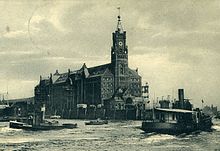
Kaispeicher A

The Kaispeicher A is a former warehouse in the Port of Hamburg on the Großer Grasbrook in what is now HafenCity . It stood in an exposed position on a farm between Sandtorhafen and Grasbrookhafen . In the first version it was in 1875 John Dalmann built, in honor of William I also Kaiserspeicher called.
After destruction in the Second World War and the later demolition of the first Kaispeicher A, the second Kaispeicher A was built on the same site in 1963, based on a design by Werner Kallmorgen .
In 2007 the outer walls of this quay warehouse were included in the construction of the Elbphilharmonie by Swiss architects Herzog & de Meuron . It was completed on October 31, 2016 and put into operation in 2017.
First Kaispeicher A by Johannes Dalmann (1875)
The first Kaispeicher A, the so-called Kaiserspeicher, was built in 1875 as a result of the port conversion to an open tidal port on the so-called Johns corner according to plans by the hydraulic engineering director Johannes Dalmann. The distinctive trapezoidal floor plan between Dalmannkai and Kaiserkai was created by straightening the quay tongue when creating the harbor basin . The brick building had a cellar, had a ground floor for handling goods and four floors for long-term storage. The outside was equipped with various hoists , so both hydraulic cranes and steam cranes were available. They could lift loads of up to 1.5 tons directly from ships in front of the hatches in the floors.
To transport the goods away, railway tracks were laid both on the quays on both sides and in the inner courtyard of the storage facility. In 1890 the City of Hamburg acquired a further Kaispeicher and called him Kaispeicher B .
The tower's timer function
The tower of the building was not only a landmark of the harbor that could be seen from afar, it also had a time ball on its top that fell twice a day at the set time until 1934. This enabled ships and individuals within sight to synchronize their clocks with an exact time. The time ball system was triggered by the observatory at Millerntor . The ball had a diameter of one meter, it was pulled up shortly beforehand and dropped at exactly noon at noon.
During the Second World War , the granary was damaged by bombs. In 1963 the undestroyed tower was blown up with the time ball and the ruins were removed for the new building without a tower. Exact clocks and radio signals took over the function.
Second Kaispeicher A by Werner Kallmorgen (1963)
The new Warehouse A, designed by architect Werner Kallmorgen was built in 1963 at 1111 concrete piles by the Elbe silt and soft soil layers of clay and peat were driven into the underlying sustainable sands. The piles have an average diameter of 50 centimeters and were designed to carry a weight of 160 tons each. The longer sides of the red brick building measured 108 and 85 meters, the height was 30 meters, the Elbphilharmonie is 73 meters higher.
Above all, cocoa and coffee from overseas were stored in Kaispeicher A after they were unloaded from the ships with large gantry cranes . In contrast to the buildings in the Speicherstadt, it was the only storage facility that was directly on the water that was deep enough for seagoing vessels. Due to the increasing containerization in maritime trade, the need for such storage areas largely decreased from the beginning of the 1970s.
literature
- Ulrich Cornehl: Room massages. The architect Werner Kallmorgen 1902–1979 . Dölling & Galitz, Hamburg 2003, ISBN 3-935549-44-X , p. 370-372 .
Web links
Individual evidence
- ^ Arnold Kludas , Dieter Maass, Susanne Sabisch: Port of Hamburg. The history of the Hamburg free port from its beginnings to the present , Hamburg 1988, p. 31 f.
Coordinates: 53 ° 32 ′ 29 ″ N , 9 ° 59 ′ 3 ″ E


