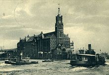
John's corner
The John's corner was the western tip of the Großer Grasbrook , today's HafenCity , and was named after the Johns shipyard, which had been located here since the beginning of the 18th century . Previously, the Hamburg Admiralty had a storage place at this place, which was in front of the city with its ramparts . From at least 1737 to 1859/1860, the Johns family ran shipbuilding at Grasbrookspitze for four generations before they had to move in the course of planning the expansion of the Port of Hamburg . After decades of discussions in the Hamburg citizenship , Johannes Dalmann's plans for the construction of a tidal port were pushed forward in 1856 and the shipyards located on the Großer Grasbrook were expropriated and relocated. The Johns'sche Werft moved to the Kleine Grasbrook , but ceased operations in 1865.
The John's corner was straightened in the course of the port construction work to allow a larger entrance to the Grasbrook harbor. The newly created Kaizunge was named Kaiserhöft and was located in the extension of the Kaiserkais. On the former John's corner, now the Kaiserhöft, Johannes Dalmann had the Kaispeicher A built in 1875 , the west tower of which was the landmark of the port until the Second World War . The building was badly damaged by bombs during the war, the tower was blown up in 1963 and the remaining building was demolished. From 1963 to 1966 the second Kaispeicher A was built on the former John's corner according to plans by Werner Kallmorgen , on whose foundation walls the Elbphilharmonie was built from 2005 .
literature
- Dieter Maass: "The expansion of the port of Hamburg": 1840 to 1910. Decision and implementation. Hamburg: Schiffahrts Verlag HANSA, 1990, ISBN 3-87700-073-8 , pp. 24 f., 29, 370–372
- The port facilities on Grasbrook. A memorandum from the Commerz Deputation . Hamburg, 1858. Here in particular Annex 2, page 9.
- Port report . Edition 3/2009 of March 17, 2009, Breitengrad Verlag GmbH Hamburg, p. 12
Individual evidence
Coordinates: 53 ° 32 ′ 29.1 ″ N , 9 ° 59 ′ 3.1 ″ E


