Grasbrook


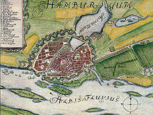
The Grasbrook (also called Neuer Brook or just Brook on older maps ) was a swampy island landscape in the glacial valley of the Elbe near Hamburg , which was mainly used as a pasture until the 19th century . It was connected to the city via the Brooktor and the associated bridge, roughly at today's Brooktor bridge. The island had never occurred deicht and thus always the Elbe floods and storm surges threatened.
At the western end of the Grasbrook there was for a long time the place of execution intended for the execution of pirates in Hamburg, where at least 428 pirates were beheaded until 1624. Among them were the Vitalien brothers , Klaus Störtebeker and Gödeke Michels .
In 1532 the northern part of the Grasbrook, the islands of Kehrwieder and Wandrahm , was included in the fortified city. Between 1568 and 1605, the island was divided with a breakthrough for the diverted North Elbe in order to make the port of Hamburg suitable for seagoing ships. This is how the two separate areas came about:
- Großer Grasbrook (north of the Norderelbe), known as the HafenCity district since 2008 , and
- Kleiner Grasbrook (south of the Norderelbe), since 1894 as a separate district.
Great Grasbrook
With the construction of the new Hamburg ramparts 1616-1628 the urban area was greatly enlarged, the fortification on the Great Grasbrook ran at roughly today's road train Sandtorkai and Brooktorkai , with her name on the two gates in the city walls refer, in West with the Georgius bastion in front of the Kehrwiederspitze and in the east with the Ericus bastion , the later Ericusspitze.
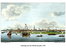
From around 1740, well-known Hamburg shipyards settled on the Großer Grasbrook . These included the Johns shipyard , after which the John's corner is named, the Sommsche shipyard and a few others. The heyday of these shipyards was reached around 1850 when, among other things, the first sailors of the newly founded shipping company HAPAG were built here (the "North America", the second HAPAG ship, was built at Johns). The expansion of the port with the construction of the Sandtorhafen and the Grasbrookhafen from the middle of the 19th century had priority. The shipyard owners were expropriated by the Hamburg Senate and relocated to the southern side of the Elbe. From 1844, the Hamburg gas works with the Grasbrook gasometer were built on the eastern side of the island, which was demolished in 1984 after the gas works closed in 1976. The Cellpapp terminal was then located here.
Since 1997 the new HafenCity district with commercial space, apartments as well as educational and cultural facilities has been built at this location . For this purpose, the newly built area will be raised to a flood-proof level by backfilling.
Little Grasbrook
Störtebeker monument by Hansjörg Wagner on Grasbrook (meanwhile moved to Magdeburg Harbor in HafenCity)
See also
literature
- Matthias Blazek: Piracy, Murder and Atonement - A 700-year history of the death penalty in Hamburg 1292-1949 . ibidem, Stuttgart 2012, ISBN 978-3-8382-0457-4
Individual evidence
- ↑ Blazek: Piracy, Murder and Atonement - A 700-year history of the death penalty in Hamburg 1292–1949, p. 41 f.
Coordinates: 53 ° 32 ' N , 10 ° 0' E


