
Wall cream

The Wandrahm is an island in the Hamburg city area, the northern part of the Grasbrook and the eastern Speicherstadt . It belongs to the HafenCity district . The island is separated from the old town by the Zollkanal in the north and the Oberhafen in the east and from the former port area by the Wandrahmfleet, St.-Annen-Fleet and Holländischbrookfleet in the south. It is separated from the Kehr again in the west by the small canal . The canals are crossed with a total of 13 bridges. The streets Neuer Wandrahm and Alter Wandrahm run through the area in an east-west direction , to the south are St. Annenufer , the Dutch Brook and the Poggenmühle .
history
In 1532, the wall frame was incorporated into the fortified city together with the neighboring island of Kehr again and the Brooktor was created. With the construction of the ramparts , this gate was also strengthened and the Ericus bastion to the east was built with the city moat .
From the 14th to the 17th century the island served the wall makers ( cloth manufacturers ) primarily as a frame yard , i.e. as a place where fabrics were set up to dry on wall frames (wooden frames) after fulling and dyeing . The wall preparation was a successful industry of the city for several centuries. Accordingly, the city built a water mill at the eastern end of the Dutch Brooks in 1555 for use as a fulling and pounding mill , which was called Poggenmühle in the vernacular pun . It was demolished in 1865.
From 1609, the wall frame was also made available for residential development, and craftsmen and merchants who immigrated from Holland in particular settled here. From the 17th to the 19th century the quarter had some well-known middle-class townhouses, for example the house Neuer Wandrahm 10 , a city palace of the merchant Theodor Kerckring , at the Neuen Wandrahm 17, the Mortzenhaus on the plots Alter Wandrahm 19-23 and the Residential and office building of the Godeffroy family at Alten Wandrahm 26, operated from 1861 to 1885 as the Godeffroy natural history museum .
Between 1660 and 1662 the large granary of the architect Hans Hamelau was built on the Alter Wandrahm, built with oak wood in half-timbered construction. It was 136 feet long, 108 feet wide and served as a large warehouse for grain, both for the municipal supply and as a price regulator: in times of price increases, grain could be sold to the needy at low prices. Since the French era, from around 1812, it was used by the military as a military hospital and barracks, from the middle of the 19th century in particular by the 2nd Hanseatic Infantry Regiment No. 76 . After they moved to a new barracks on Bundesstrasse, the building was demolished in 1871.

Kornhaus an Alten Wandrahm, 1862
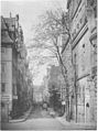
New wall cream, 1885

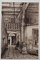
Old wall cream, corner of Poggenmühle, 1885
Old wall cream, 1883


As early as 1564, when the inner-city cemeteries ran out of space during a plague epidemic , the parish of St. Katharinen laid out the St. Anne's cemetery . In 1566, the St. Annen Chapel was built around today's corner of St. Annenufer / Bei St. Annen . Since the poor from the community were buried at parish costs and also suicides in the cemetery, it was considered Arm-Lüds-Karkhof . The cemetery was closed in 1812 and the dilapidated chapel was demolished in 1869 as the road was widened.
In addition to the street names that have been preserved, a group of figures with the sculptures of St. Anna and her daughter Maria south of the wall frame on the northeast corner of the former administration building of the Hamburger Freihafen-Lagerhaus-Gesellschaft (HFLG) is reminiscent of the burial chapel. St. Anna is the patroness of miners and boatmen and merchants.

St. Anne's funeral chapel, before 1869; St. Catherine's Church can be seen in the background

Corner of St. Annenufer / Bei St. Annen; also here in the background St. Catherine's Church

Neuerweg bridge over St. Annenfleet, on the left the first administration building of the port authority at that time (HFLG administration building)
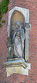
Sculpture group St. Anna and Maria at the former HFLG administration building

.ajb.jpg)


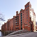
From 1886 the entire residential area was demolished for the construction of the Speicherstadt. From 1891 to 1897 the storage blocks P, Q and R were built on St. Annenufer and Neuer Wandrahm and from 1899 to 1927, interrupted by the First World War, blocks S to X in the area east of the street near St. Annen.
bridges
As an island, but also as part of the Speicherstadt, which is criss-crossed by numerous canals, the wall frame has a relatively high density of bridges.
Bridges over the Zollkanal, which connect the wall frame to the old town:
- Jungfernbrücke : pedestrian bridge between Katharinenkirchhof and Neuer Wandrahm , the name corresponded to the Kleiner Jungfernstieg , which before the Speicherstadt was built between Neuem Wandrahm and Holländischer Reihe (today St. Annenufer);
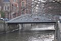
- Kornhausbrücke : from Brandstwiete to Bei St. Annen , named after the Kornhaus that existed on the Neuer Wandrahm until 1871;
- Wall frame bridge: pedestrian bridge from Willy-Brandt-Straße to Teerhof , until 1962 the large wall frame bridge existed at this point ;
- Oberbaumbrücke : leads across the Oberhafen and connects Deichtorplatz with the Poggenmühle ; The name comes from the blockade of the harbor entrance with a row of wooden stakes, which existed from 1531, corresponding to the Niederbaum block at the inland port.

Maiden Bridge

Kornhausbrücke
Wall frame bridge
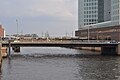
Oberbaum Bridge
.3.ajb.jpg)

.Block_W_Ost.Wandrahmsteg.ajb.jpg)
.ajb.jpg)
Bridges over the Kleine Fleet, which establish a connection from the wall frame to the Kehr again:
- Kannengießerbrücke : along Brook and Neuer Wandrahm streets ;
- Pickhuben bridge : with the way the road Pickhuben to Kannengießerort, the term Pickhuben refers to the unlucky bunch of back to the 17th century working here shipbuilders ;

Kannengießer Bridge

Pickhubenbrücke

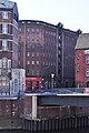
Wall frame bridge, 1883

.1.ajb.jpg)

Bridges over the Wandrahmsfleet:
- Kannengießerortbrücke : along the Kannengießerort street;
- Wall preparer bridge : in the course of the street near St. Annen ;
- Wandrahmsfleetbrücke : leads from Zoll to Holländischer Brook along the Dienerreihe road ;
- Poggenmühlenbrücke : is a double bridge, i.e. a bridge with divided lanes, it leads from the Teerhof to the Poggenmühle ; is named after the milling and punching mill that existed here until 1865.

Kannengießerortbrücke

Wall preparer bridge

Wandrahmsfleetbrücke

Poggenmühlenbrücke

.Block_P.Fleetseite.Wandbereiterbr%C3%BCcke.ajb.jpg)
.ajb.jpg)
.2.hf.phb.ajb.jpg)
Bridges over the St.-Annen-Fleet and Holländischbrookfleet:
- Neuerwegsbrücke : as an extension of the Pickhubenbrücke;
- St. Annenbrücke : in the course of the street near St. Annen ;
- Holländischbrookfleetbrücke : leads from Holländischer Brook to Brooktorkai in the course of the Dienerreihe road , as an extension of the Wandrahmsfleetbrücke.
Neuerweg Bridge

St. Anne's Bridge
Holländischbrooksfleetbrücke
.3.ajb.jpg)
.ajb.jpg)
.Block_X.Holl%C3%A4ndischbrookfleetbr%C3%BCcke.ajb.jpg)
Individual evidence
- ↑ Gert Kähler , Sandra Schürmann: Traces of History , workbook 5 of HafenCity GmbH, new edition 2010, p. 23 available as pdf files
- ↑ Barbara Leisner, Norbert Fischer: Der Friedhofsführer. Walks to known and unknown graves in and around Hamburg , Christians Verlag, Hamburg 1994, p. 25 f.
- ↑ Ralf Lange: Patroness of the Speicherstadt , Quartier Magazin for HafenCity, Speicherstadt and Katharinenviertel, June to August 2009 ( Memento of the original from August 21, 2016 in the Internet Archive ) Info: The archive link was inserted automatically and has not yet been checked. Please check the original and archive link according to the instructions and then remove this notice. , accessed December 12, 2013
- ↑ Eva Maria Bast: The biblical grandma from the Speicherstadt. "Hamburger Abendblatt", October 29, 2016, p. 13.
- ^ Horst Beckershaus: The Hamburg bridges. Their names - where they come from and what they mean , Hamburg 2007, ISBN 978-3-86633-007-8
Web links
Coordinates: 53 ° 33 ' N , 10 ° 0' E