Customs channel
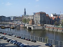
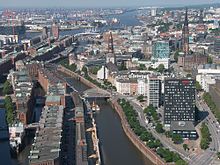
The customs canal in Hamburg runs on the northern edge of the Speicherstadt and until 2013 formed the customs border between the old town and the then free port area . At the end of the 19th century it was expanded from existing waters ( inland port , Dovenfleet, Mührenfleet, Oberhafen ) into a shipping canal in order to bypass the free port area newly created in 1888. The customs canal thus connected the customs inland, while the free port area was customs abroad.
history
Even after the establishment of the German Empire in 1871, parts of Altona , Hamburg, Wandsbek and Wilhelmsburg formed a district that was customs foreign to the German Empire. Customs borders in Hamburg were, for example, in Hoheluft on Martinistraße, in Barmbek by the bridge over the Osterbek and in Wandsbek on Zollstraße. Based on an agreement with the Reich, the named places were to become customs inland. However, Hamburg received the privilege, which is still valid today, to dispose of an area in the port that was foreign customs.
Corresponding construction work had to be completed by October 15, 1888 - the date of the customs connection to the German Reich. This included the construction of the warehouse district . Several projects were discussed and from project IV a water connection between the Upper and Lower Elbe was part of the planning, which ran outside the free port area. Initial plans envisaged its course even further north than it is now, so that the Katharinenkirche would have been located south of it. In the end, however, access to the buildings in Hamburg's old town that was to be demolished was limited and the customs canal was laid in today's course. For this purpose, the waters of the inland port (also called Deep ) and the upper port , which have existed since the Middle Ages, were widened . This connection to the Elbe was created in 1258 from the mouth of the Bill and a branch canal to the northern Elbe and formed an important part of the original port facilities ( see also: History of the Port of Hamburg ).
This water connection had a political component towards Berlin, because Hamburg documented with its construction that this resulted in a permanent new regulation of the customs relations with regard to the German Reich. Therefore, the color in which the customs canal was drawn in the plans was jokingly referred to as "Prussian blue"

Course, width and depth
A width of 45 meters was planned for the customs canal to ensure a smooth flow of traffic. The canal should be passable at all times, including at low tide. Since the canal is directly connected to the Elbe without a lock , the ebb and flow of the tides affect it.
To the north, the Zollkanal is now bordered by the flood protection wall for Hamburg's old town and the street on the edge of the harbor, which for historical reasons is called Bei dem neue Krahn, Bei den Mühren, Zippelhaus and Dovenfleet . The Katharinenkirche is located directly north of this street. The Zollkanal (from west to east) is bridged by the Brooksbrücke (as an extension of the Mattentwiete), the Jungfernbrücke (near the Katharinenkirche) for pedestrians, the Kornhausbrücke (extension of the Brandstwiete ), the Wandrahmsteg (near the Meßberg ) and the Oberbaumbrücke, behind the the upper harbor begins. The Zollkanal itself borders the Speicherstadt with its goods stored there to the north like a moat.
With the construction of the new HafenCity , the Zollkanal is taking over the demarcation of the new district from the old town of Hamburg.
Individual evidence
- ↑ Helmut Stubbe da Luz : Grasbrook. In: Franklin Kopitzsch , Daniel Tilgner (Ed.): Hamburg Lexikon. Zeiseverlag, Hamburg 1998, ISBN 3-9805687-9-2 , p. 183.
- ↑ Karin Maak, Speicherstadt, p. 58 - on the occasion of a celebration for the anniversary of Obering's service. FA Meyer
literature
- Karin Maak: The Speicherstadt in Hamburg's free port. Christians Verlag, Hamburg 1985, ISBN 3-7672-0907-1 .
Web links
Coordinates: 53 ° 32 ′ 40 " N , 9 ° 59 ′ 34" E


