
Rheinauhafen

The Rheinauhafen is a former port facility in the southern part of Cologne , which is used today as a residential , office , service and commercial area.
Location and importance
The street Im Zollhafen , on which the crane houses are located, runs across the “Werthchen” peninsula . Its southern continuation is called Anna-Schneider-Steig, further south the street is finally called Agrippinawerft. The Rheinuferstraße ( ![]() ) runs parallel to the peninsula along the left bank of the Rhine, here called Am Leystapel / Holzmarkt / Bayenstraße / Agrippinaufer. The Severinsbrücke leads across the peninsula. Today's Rheinauhafen no longer has a port function, but is a residential and commercial area. It covers a land area of 15.4 ha and a water area of 5.7 ha. The existing building stock is used for offices / services (51%), apartments (31%) and art and culture (18%). A total of 2200 jobs were created here, around 1500 people live in the 235,000 m² area.
) runs parallel to the peninsula along the left bank of the Rhine, here called Am Leystapel / Holzmarkt / Bayenstraße / Agrippinaufer. The Severinsbrücke leads across the peninsula. Today's Rheinauhafen no longer has a port function, but is a residential and commercial area. It covers a land area of 15.4 ha and a water area of 5.7 ha. The existing building stock is used for offices / services (51%), apartments (31%) and art and culture (18%). A total of 2200 jobs were created here, around 1500 people live in the 235,000 m² area.
history


.jpg)

middle Ages
Already on the first, large Cologne Cityscape of 1531 of Anton Woensam can be seen clearly, is that the port along the left bank of the city wall stretched and was very busy. Accordingly, there were also port and shipyard activities on the Rhine island “ Werthchen ”. Loading and unloading was done using cranes. The berths of the Oberländer ships were in front of the Cologne Rhine bank south of the Salzgassen gate. To the north of it, the slightly larger, more bulbous Dutch, who came from a different shipbuilding tradition, anchored. If you look at the ratio between Oberland and Dutch people, there are almost twice as many Oberlanders in front of Cologne than Dutch people, which corresponds to the different size and carrying capacity. A harbor master supervised the anchorages, the collection of fees and the maintenance of the harbor facilities. The Rheininsel Werthchen is also drawn in the Cologne cityscape from 1570 by Arnold Mercator and shows ships lying on the bank at the height of the Holzmarkt. On the island itself there are no port activities to be seen at Mercator. The 720 meter long and up to 40 meter wide Werthchen was supposed to play a decisive role in the construction of a new port during the early days of the company .
Founding period
During the early days, the bank protection systems on the Rhine served as port facilities. The "Napoleonhafen" ("Franzosenhafen") was created as a winter harbor during the French period up to 1813 between Ebertplatz and Bastei , where on November 10th 1812 the first stone of the harbor mouth was laid. In the spring of 1811, the first basin port was built north of St. Kunibert , a security port that could be used at the end of 1813. However, it had been created incorrectly and was quickly silting up; his capacities were also insufficient from the start. It lost its importance until 1840.
A major change in the traffic flow on the Rhine resulted from the switch from towing to steam shipping . On June 12, 1816, the English steamship “Defiance” (“The Challenge”) from James Watt reached Cologne. In the autumn of 1817, James Watt sailed the Rhine with the “ Caledonia ” and in October 1817 reached Cologne from Rotterdam. In July 1821 the first steamboat made the journey on the Rhine from Rotterdam to Cologne in just under 6 days. In 1813 there were 689, in 1821 there were 875 sailors; During this time, the Cologne port throughput doubled from 3.2 to 6.4 million quintals. Since August 1825 there has been a regular ship connection between Cologne and Rotterdam, including for passengers. On June 11, 1826, the Sal. Oppenheim bank founded the “Preußisch-Rheinische Dampfschifffahrtsgesellschaft”, which began operations in May 1827 with two steamers. The growing importance of Cologne as one of the largest trading cities required the construction of a new Cologne port.
The value at Rhine kilometer 687.5 played the central role in the planning of the new Cologne port. The Cologne Chamber of Commerce had indicated in 1847 that the city would receive a new shipyard through a Rheinauhafen. City architect Bernhard Wilhelm Harperath and fortress engineer Carl Schnitzler planned in 1847 a connection between the southern part of the Rhine island and the left bank of the Rhine in order to create a peninsula from the island. Construction work on Werthchen began in 1847 and led to the closure of the southern river passage. In 1848 Johann Anton Wallé designed the construction of a security port on Werthchen. The city then selected the area around the Rheinauinsel “Werthchen” as the new port area. The newly created harbor basin, which can only be reached from the north, was completely enclosed by shipyard walls. On November 27, 1852, the police issued an “Ordinance on the Security Harbor on the Rheinau”. In order to monitor the northern entrance, the neo-Gothic Malakoffturm was completed on the tip of the island in 1855 , the design of which was modeled on the medieval Bayenturm .

Construction of the Rheinauhafen
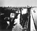
Rheinau - View from the Bayenturm to the unfinished cathedral (around 1870)

Rheinauhafen - inauguration on May 14, 1898

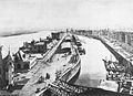
Rheinauhafen shortly before completion around 1898

Rheinauhafen - View in North Direction (1898)
Rheinauhafen - View in South Direction (1898)

Rheinauhafen - Port Authority (1898)
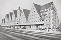
Rheinauhafen - "Siebengebirge" with tracks (around 1910)

Port view from 1921


,_RBA.jpg&filetimestamp=20141105140539&)
In the competition design by Josef Stübben and Karl Henrici in 1880 there was also a proposal for the construction of the Rheinauhafen. When Stübben was appointed city architect in Cologne in 1881, he initially concentrated on other construction projects. The "Port Reform Commission", founded in 1884, was headed by Stübben and supported the plans for the port construction. The southern project planned by Stübben and Henrici initially encountered resistance from the railroad, but after lengthy negotiations they agreed to the southern project.
On November 5, 1885, the City Council of Cologne decided in favor of the "Basin on the Bayen" and favored the Rheinauhafen basin as the location for a new, enlarged port. Between 1886 and 1891 the shipyard wall at the Leystapel and at the Zollhafen (today part of the Frankenwerft) as well as on today's Konrad-Adenauer-Ufer up to Machabäerstrasse was renewed, then the actual Rheinauhafen followed from 1892 to 1898. On July 3, 1891, the council decided to build the port on the basis of the overall plan of Stübben and approved almost 20 million marks for this. The construction work on the “New Port and Shipyard in Cologne” began in the spring of 1892 with earthworks and led to an expansion of the entire facility to 26,200 m² with a usable area of 16,300 m² for the warehouses; In addition, the harbor basin was completely rebuilt and enlarged to 5.7 hectares, while the permanent bank area (“Bayenwerft” and “Holzwerft”) in front of the old city limits was expanded and redesigned. The bank line was partially shifted significantly into the Rhine by backfilling: most of all at the Agrippina shipyard with a width of 105 meters, at the Oberländer shipyard 40 to 90 meters, at the Leystapel and Frankenwerft up to 9.5 meters, on the Konrad-Adenauer-Ufer between 25 and 35 meters. The "Bayenwerft" runs to the Mechtildisrampe, from then on it is called "Holzwerft" up to the mouth of the harbor. The customs port yard opened in April 1888, the port customs office designed by Georg Eberlein ("main service building" with differentiated gables, hipped and hooded roofs on stair towers and bay windows) in May 1898.
The new peninsula was created by backfilling and fortifying the bank with shipyard walls on the river and basin side. This resulted in a widening of this new peninsula from previously 40 meters in the middle to now 75 meters over the entire length. In total, the Rheinauhafen is 850 meters long, 60 meters in the middle and 30 meters wide at the ends. The customs office moved its headquarters from the banks of the Rhine to the peninsula, where the port office and three large warehouses were also located. After the opening of the swing bridge in Rheinauhafen on August 5, 1896, the ceremonial inauguration of the new Rheinauhafen took place on May 14, 1898 in the presence of the Prussian ministers Johannes von Miquel , Karl von Thielen , Eberhard von der Recke von der Horst and Ludwig Brefeld . The Rheinauhafen received a siding with 18 km of tracks and 96 points and had the most modern technical port facilities in Germany. At the southern end of the harbor basin, the city harbor authority, which was planned by Adam Sesterhenn and provided with a decorated brick facade, a striking clock tower and corner tower and inaugurated in May 1898, followed the power house for operating the hydraulic systems and a locomotive shed - to the south of it the harbor station. In 1898 the port traffic exceeded the port turnover of 1 million tons, when the industrial port was completed in 1907 it was already 1.036 million tons, in 1913 it was already 1.41 million tons.
The now fortified peninsula was divided into the 510 meter long customs port (which corresponded to seven ship lengths at the time) in the northeast and the remaining area with warehouses and shipyards for private companies. The customs port included the high-rise buildings of the state “main service building” on the northern tip opposite the Malakoffturm, as well as the so-called “small service building” as well as warehouses 1, 2 and 3 (later halls 10, 11 and 12).
Modern times

Rheinauhafen - Panorama from the south bridge (June 2009)

Rheinauhafen - Anna-Schneider-Steg / Laura-Oelbermann-Promenade

Rheinauhafen - Silo 23 (July 2013)

Rheinauhafen - port crane "dicker Herkules" (built 1897)
Rheinauhafen - German Sports & Olympic Museum (April 2010)

Rheinauhafen - Skate Plaza (August 2011)

Rheinauhafen - Tauzieher (July 2012)

Rainbow in the Rheinauhafen Cologne (2014)

Nocturnal view from the Severinsbrücke into the port basin of the Rheinauhafen. (2016)

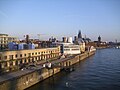
View over the Rheinauhafen, Cologne (2017)

Kranhäuser im Rheinauhafen, Cologne (2017)
Chocolate Museum in the Rheinauhafen Cologne (2017)


.jpg)

.jpg)

_(2).jpg)

.jpg)
.jpg)
.jpg)
On May 24, 1902, the first harbor fire station was opened in the Rheinauhafen. In 1992 the discharge station was relocated to the opposite bank in the port of Deutz due to the construction of the chocolate museum. Opposite the customs office, the tug of war designed by Nikolaus Friedrich was erected on March 4, 1911 as the first free sculpture in Cologne. Among the 41 cranes was the now listed "fat Hercules", a port crane built in 1897 by the Ludwig Stuckenholz company from Wetter on the Ruhr with a maximum lifting capacity of 30,000 kg. He lifted the 24-tonne “thick Pitter” ( Petersglocke ) on November 14, 1924 from a special wagon of the Reichsbahn onto a low-loader that took it to Cologne Cathedral . In March 1938 the first expansion plans for a monumental building in direct extension of the warehouse ("Siebengebirge") were drawn up in the Rheinauhafen, which were then carried out in a slightly different form in 1940 by the building contractor Carl Brandt. This "Silo 23" is due to its height and the distinctive roof shape to this day a defining part of the harbor silhouette on the banks of the Rhine. When the Cologne water level was destroyed after a bomb attack on June 29, 1943 , the water level in Rheinauhafen (Rhine kilometer 687.6) was used until March 1, 1948. In 1951, the Rheinauhafen was still the most important of the four Cologne ports. It then lost its importance due to the expansion of other Cologne ports. These included the Mülheimer Hafen (opened in 1880), Godorfer Hafen (1901), Deutzer Hafen (1907), Niehl I (1925) and Niehl II (1958).

Starting in 1946, the city planned to give up the Rheinauhafen later, accompanied by the corresponding expansion of the Niehl I port into a commercial and industrial port. After its complete expansion in 1970, the port function moved to Niehl I and opened the way as a marina in the Rheinauhafen. In addition, the modern large ships no longer fit into the 18.84 meter narrow port entrance. The outdated port facilities of the Rheinauhafen were not in use from 1971, so that the council decision of July 13, 1976 promised the conversion of the port area into a "leisure and recreation facility". After the "Häfen Köln GmbH" was founded in 1986, this company became the owner of all Cologne ports, including the Rheinau port. The overall port concept adopted by the City of Cologne on March 3, 1988 assigned the ports of Rheinau and Mülheim a “subordinate importance”. The abandonment of the Rheinauhafen thus freed up inner-city areas for urban development. Since March 1998, the Rheinauhafen has been redeveloped and redesigned by Häfen und Güterverkehr Köln AG (HGK) and the City of Cologne. On the one hand, architecturally sophisticated new buildings were built on previous fallow land, but at the same time old buildings such as the “Siebengebirge” or the former port authority were extensively restored and re-used - usually as office or residential buildings. Further use of the location is in the cultural and gastronomic area.

In 2001 the port operations were completely stopped. A legally binding development plan for the Rheinauhafen was in place on August 5, 2002. The first building to open was the underground car park in November 2003. With a length of 1.6 km, 41,000 square meters and around 1,400 parking spaces, it is Europe's longest and second-longest underground car park in the world. The garage facility, which is 6.7 meters deep at Cologne level, is considered flood-proof up to a Rhine level of 11.30 meters. In 2013, the underground car park was officially named the best car park in town. The promenade was expanded until November 2009. A total of 6 listed harbor cranes are a reminder of the former port function with 41 cranes. After further redesigns, the Rheinauhafen was opened on June 21, 2014.
Building (selection)

.jpg)


.jpg)

Numerous new buildings were built in the Rheinauhafen, old listed buildings were completely renovated and provided for another use. 154,000 m² of usable space was available for this:
- Imhoff Chocolate Museum (Am Schokoladenmuseum 1a): It consists of a new building completed by October 1993 and the renovated former Prussian Customs Office ("main service building") from 1898. The chocolate museum designed by Fritz Eller was inaugurated on November 3, 1993.
- German Sport & Olympia Museum (Im Zollhafen 1): it is located in the listed "Zollhalle 10", a warehouse built in 1898 by Bernhard Below (like Halls 11 and 12), opened on November 26, 1999 with 2000 m² of exhibition space . The operator is the non-profit foundation Deutsches Sport & Olympia Museum , founded in Cologne on December 15, 1998 .
- Hall 11 (Im Zollhafen 5–9): residential and commercial building with 7250 m² residential and 6750 m² commercial space, a former warehouse (ready for occupancy since October 2008).
- Hall 12 (Im Zollhafen 13): residential and commercial building, a former warehouse (ready for occupancy since December 2009).
- Dock 6-10 (Im Zollhafen 6-10): 110 meter long residential and commercial building (40,000 m²), ready for occupancy since October 2013.
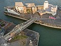
- Kranhäuser (Im Zollhafen 12, 18 and 24): three residential or commercial buildings modeled on a harbor crane with a gross floor area of 52,950 m². In the architecturally and visually spectacular building shape, a two-part boom protrudes from a height of 40 meters, which only rests on a slim, fully glazed stair tower. They are the eye-catcher of the Rheinauhafen and shape the modern Cologne cityscape.
- The Bench (Im Zollhafen 15-17): a 7,600 m² office building (ready for occupancy since October 2007).
- Kontor 19 (Anna-Schneider-Steig 8–10): Commercial building with 7230 m² gross floor area (ready for occupancy since January 2006).
- Rheinkontor (Agrippinawerft 6): residential complex, former office building from 1909 (ready for occupancy since October 2006).
- "Siebengebirge" (Agrippinawerft 12-20): 177 meters long and 30 meters high six-storey residential and commercial building (living space: 15700 m², commercial space: 3300 m²), built in 1909/1910 by Hans Verbeek as a warehouse ("Danzig warehouse") Building complex as one of the first reinforced concrete skeleton structures in Germany, the renovation and renovation of which lasted until October 2006. The name can be traced back to the seven (nine on the Rhine side) pronounced gables . Originally, the warehouses were used to store grain and general cargo, after which they were used as granaries. Until 1990 it served as a wheat store for the national emergency reserve.
- SILO 23 (Agrippinawerft 24): a commercial building with 3,800 m² rental space, emerged from a granary built in 1940 (ready for occupancy since May 2007).
- KAP am Südkai (Agrippinawerft 30): the first new building in Rheinauhafen is an office building with 12,700 m² and 10 upper floors (ready for occupancy since October 2004).
- RheinauArtOffce (Holzmarkt 2): This is where the NRW office of Microsoft Deutschland GmbH, the anchor tenant with 4750 m² in the 10400 m² large, strikingly shaped building , has resided since September 2008 .
- Luther building (Baufeld21): The company Luther Rechtsanwaltsgesellschaft mbH has its headquarters in this building . In 2008, the company moved there, and since then the Baufeld21 building has also been called the "Luther building".
- rhein3 : is a residential building on the Rhine with around 16 apartments and 2 office units.
- The port authority (Bayenstrasse 2) housed the ports and freight traffic of Cologne until April 2014 .
- Pier 15 (Bayenwerft 12–14): Commercial building with the headquarters of the consulting and software company ifp group (ready for occupancy since April 2009).
- The "Kap 686" facility, which was inaugurated in July 2011, is officially built as a skate park for skaters and has met with a high level of acceptance. Thanks to them, the skaters , which were rather annoying on the cathedral plate, have disappeared.
literature
- Klaus Kuschek: 686.4. The Rheinauhafen Cologne , with an introduction by Hajo Steinert , Greven-Verlag, Cologne 2012, ISBN 978-3-7743-0605-9 .
- Joseph Stübben u. a .: New shipyard and port facilities in Cologne . Festschrift for May 14, 1898.
- Ines Waschkau: The Rheinauhafen - Cologne's new in-mile . JP Bachem Verlag, Cologne 2008, ISBN 978-3-7616-2188-2 .
- Architects and Engineers Association Cologne-Bonn eV from 1875 (Hrsg.): Cologne - his buildings. The Rheinauhafen . JP Bachem Verlag , Cologne 2010, ISBN 978-3-7616-2231-5 .
Web links
Individual evidence
- ↑ Carl Dietmar, Das Late Medieval Cologne , 2nd edition 2004, p. 111
- ↑ Large clinker ships with a widened bow and a raised stern
- ↑ flat-bottomed clinker-built angular cargo ships; Called "Aak", in Holland "Keulenaar"
- ↑ Josef Doll Hoff, Cologne Rheinschiffahrt. , 1980, p. 25 ff.
- ↑ Marko Gebert, fortress and city of Cologne , 2013, p. 52 ff.
- ↑ Friedrich Everhard von Mering / Ludwig Reischert, On the history of the city of Cologne on the Rhine , Volume 1, 1838, p. 43 f.
- ↑ Josef Doll Hoff, Cologne Rheinschiffahrt. , 1980, p. 49.
- ↑ a b Wilhelm Treue, Wirtschafts- und Technikgeschichte Preussens , 1984, p. 425.
- ↑ Peter Fuchs (Ed.), Chronik zur Geschichte der Stadt Köln , Volume 2, 1991, p. 163.
- ^ Cologne and its buildings , Association of German Architects, 1888, p. 358 ff.
- ↑ a b Adolf Klein, Cologne in the 19th Century: From the Imperial City to the Big City , 1992, p. 293 f.
- ↑ a b Otto Schneider, Cologne as a shipping location from the end of the 18th century to 1913 , 1928, p. 113.
- ↑ Waterways and Shipping Directorate Duisburg, Der Rheine: Expansion, Traffic, Administration , 1951, p. 355.
- ↑ Werner Baecker, Cologne: His buildings 1928-1988 , 1991, p. 455.
- ^ The Rheinau underground car park: The Alpine tunnel in the cathedral city , koeln.de, accessed on June 23, 2014.
- ↑ The Rheinauhafen Cologne attraction has a new showcase district , n-tv.de, accessed on June 23, 2014.
- ↑ Underground car park at Rheinauhafen Best car park selected , rundschau-online.de, accessed on June 23, 2014.
- ↑ Plot 21 - Luther Building | Rheinauhafen Cologne. Retrieved February 22, 2018 .
- ↑ rhine3 | Rheinauhafen Cologne. Retrieved February 22, 2018 .
Coordinates: 50 ° 55 ′ 43 " N , 6 ° 57 ′ 51" E