
Werthchen

.jpg)

The Werthchen - also called Rheinau Island - was a Cologne Rhine island at the level of the south of the old town .
location
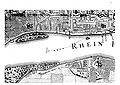
The Rhine island Werthchen was only separated by a narrow fairway in front of the Cologne city wall on the banks of the Rhine , below the Bayenturm downriver to around St. Maria Lyskirchen . In the entire Rhine there were several such natural islands, which are called Werth on the Middle and Lower Rhine (see for example Grafenwerth , Nonnenwerth , Kaiserswerth ).
history
The Rhine island, which was created in the Middle Ages by an arm of the Rhine at the Katharinengraben north of the Bayenturm, appears for the first time in a document in 1446 as “up der warden buyssen Beyers” and in 1473 as “the value at Baien an der Arken”. Because of its small extension of 720 meters in length and up to 40 meters in width, it is henceforth called “Werthchen” in the diminutive . Executions were still taking place on the Werthchen at the beginning of the 13th century.

The little value on Arnold Mercator's view of the Cologne city from 1570
Cologne city map from 1752 - The little value on Johann Valentin Reinhardt's city view from 1752

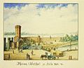
Rhein-Au - Pavilion (around 1840)
Werthchen zu Cologne, painting by Tilmann Watler (1860)


Early use
The Werthchen was not only used to build ships, but also for agriculture and later as a recreational destination for the Cologne residents. The function as a shipyard location is particularly clear on the section of the Cologne cityscape from 1531 by Anton Woensam . This shows the simultaneous construction of two smaller ships and a large Oberland merchant ship. Apparently the island is home to numerous shipyard workers. In the vicinity of Werthchen, the Cologne Rhine mills worked in the river, which were driven by the river and handled most of the grinding work for the city. They were evidently maneuvered from Werthchen with strong teams. Woensam's picture also shows the use as a pasture for cattle. There were bleaching places on the island. The Rhine island is also drawn in the Cologne cityscape from 1570 by Arnold Mercator and shows ships lying on the bank at the height of the Holzmarkt. The island itself has only 3 houses and a boat. In Reinhardt's Cologne city map from 1752 , only forests and meadows can be seen.
Garden design
A graphic from the Cologne City Museum from 1825 shows the Werthchen completely covered with trees and bushes. There were poplars, alders, linden trees and willows. Since 1833 the population of Cologne used this Rhine island as a recreation area. That year the city signed a contract with the gas manufacturer Conrad Joseph Stroof, according to which he should build a bridge and a pavilion with restoration on the island. Cologne's first gas lantern burned in the island's pavilion. On July 13, 1833, the art historian Sulpiz Boisserée was able to visit the park “auf dem Werth”, which was laid out in the style of an English garden and was henceforth called “the Au”.
Garden director Jakob Greiß took over the further design of the island in 1833. A colored aquatint by Johann Adolf Lasinsky from 1845 also shows the island's dense forest cover. A watercolor by Tillmann Wattler from 1850 shows a small bridge between the - also tree-lined - bank of the Rhine and the island. Garden designer Anton Strauss rebuilt the Rheinau plant on the Werthchen in 1868, later the design of parts of the Cologne green belt followed . In the 1870s, the “Werthchen” restaurant with its excursion restaurant was one of the favorite places to stay for Cologne families in the south of the city.
Rheinauhafen
City architect Bernhard Wilhelm Harperath and fortress engineer Carl Schnitzler planned in 1847 a connection between the southern part of the Rhine island and the left bank of the Rhine in order to create a peninsula from the island. Construction work on Werthchen began in 1847 and led to the closure of the southern river passage. In 1848 Johann Anton Wallé designed the construction of a security port on Werthchen. On July 3, 1891, the City Council of Cologne decided to build the port with the involvement of Werthchen and approved almost 20 million marks for this. The newly created harbor basin, which can only be reached from the north, was completely enclosed by shipyard walls. In order to monitor the northern entrance, the neo-Gothic Malakoffturm was completed on the northern tip of the island in 1855 , the design of which was modeled on the medieval Bayenturm.
The Werthchen, now functioning as a peninsula in the Rheinauhafen, received bank reinforcements on both sides and was enlarged to a width of 77 meters. Warehouses, port and customs offices as well as port cranes and track systems were built on the peninsula. As early as 1891 the city transplanted 76 large linden trees in the new construction of the Rathenauplatz. After 8 years of construction, the Rheinauhafen was officially opened here on May 14, 1898 . He was until 1970 Cologne's main port and lost in that year most of its port functions to the port Niehl I .
literature
- Hugo Borger / Günter Zehnder: Cologne, the city as a work of art: city views from 15.-20. Century. 2nd edition, Greven Verlag, Cologne 1986, ISBN 3-7743-0222-7 .
Individual evidence
- ↑ Ludwig Röhrscheid, Rheinische Vierteljahresblätter , Volume 31, 1967, p. 376
- ↑ Yvonne Leiverkus, Cologne: pictures of a late medieval city , 2005 S. 61st
- ^ Hugo Borger / Frank Günter Zehnder, Cologne, the city as a work of art , 1982, p. 168, p. 230.
- ↑ Anna Dünnebier: The City, the Tower, the Women ( Memento of the original from May 9, 2010 in the Internet Archive ) Info: The archive link was automatically inserted and not yet checked. Please check the original and archive link according to the instructions and then remove this notice. , on the FrauenMediaTurm website
- ↑ Cologne City Museum, graph. Collection 1825, RBA 94485, in: Picture index of art and architecture ("Marburg picture index")
- ^ Josef Klersch / Heribert A. Hilgers, From the Imperial City to the Large City , 1925, p. 39.
- ↑ Cologne City Museum, graph. Collection AI 2/218, in: Picture index of art and architecture ("Marburg picture index"); see also: Hugo Borger / Frank Günter Zehnder, Cologne, the city as a work of art , 1982, p. 168, p. 230.
- ↑ Note PDF in a diploma thesis at "Pro Stadtgarten e.V." ( Memento of the original from November 27, 2013 in the Internet Archive ) Info: The archive link was inserted automatically and has not yet been checked. Please check the original and archive link according to the instructions and then remove this notice.
- ^ René Zey: Parks in Cologne: A guide through the green spaces . Greven, Cologne 1993, ISBN 3-7743-0273-1 , p. 24 .
- ↑ Peter Fuchs (Ed.), Chronik zur Geschichte der Stadt Köln , Volume 2, 1991, p. 163.
- ↑ Peter Fuchs (ed.), Chronik zur Geschichte der Stadt Köln , Volume 2, 1991, p. 344.
See also
Coordinates: 50 ° 55 ′ 40.3 " N , 6 ° 57 ′ 56.8" E