
Cologne level

The small pointer shows the meter, the large one the decimeter of the water level. Water level in the photo: 4.18 m
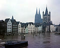
The Cologne gauge is located in the north of Cologne's old town on the left bank of the Rhine and measures the water level of the Rhine at river kilometer 688. It is one of 22 gauges on the Rhine and, next to the Kaub gauge, the most important. It is operated by the Cologne Waterways and Shipping Authority .
history

Rhine flood in Cologne in 1784 (engraving by Johann Baptist Bergmüller , who also placed a few Augsburg buildings in addition to Great St. Martin )

Cologne-Mülheim - Clemens Church (November 1882)

Cologne gauge - flood (November 1930)
Cologne gauge - flood (February 1970)

Cologne gauge - flood (April 1983)

Cologne gauge (July 2014)


| date | Water level |
|---|---|
| December 26, 1819 | 9.69 meters |
| 01/22/1820 | 9.40 meters |
| 11/16/1824 | 9.50 meters |
| 12/27/1833 | 9.19 meters |
| 02/29/1844 | 9.55 meters |
| 03/29/1845 | 10.34 meters |
| 01/29/1846 | 9.36 meters |
| 02/05/1850 | 10.28 meters |
| 02/05/1862 | 9.49 meters |
| 02/11/1867 | 9.11 meters |
| 1875 | 9.03 meters |
| 03/14/1876 | 9.76 meters |
| 05/01/1880 | 9.13 meters |
| 12/22/1880 | 9.03 meters |
| 11/29/1882 | 10.52 meters |
| 01/02/1883 | 9.94 meters |
| 01/01/1920 | 9.62 meters |
| 01/16/1920 | 10.58 meters |
| 05/11/1924 | 9.80 meters |
| 01/01/1926 | 10.69 meters |
| 11/25/1930 | 9.13 meters |
| 11/28/1944 | 9.12 meters |
| 02/16/1945 | 9.01 meters |
| 02/11/1946 | 9.32 meters |
| 01/02/1948 | 10.41 meters |
| 01/21/1948 | 9.24 meters |
| January 19, 1955 | 9.70 meters |
| 02/27/1958 | 9.33 meters |
| 02/25/1970 | 9.87 meters |
| 02/08/1980 | 9.31 meters |
| 04/14/1983 | 9.81 meters |
| 05/30/1983 | 9.96 meters |
| 02/10/1984 | 9.11 meters |
| March 29, 1988 | 9.95 meters |
| December 23, 1993 | 10.63 meters |
| 01/21/1995 | 10.69 meters |
| 11/02/1998 | 9.49 meters |
| 03/25/2001 | 9.38 meters |
| 05/01/2003 | 9.71 meters |
Level-based water level measurements were available in Cologne from at least around 1771, because the chief building officer Johann Esaias Silberschlag reported on this in his book "Hydrotechnik" published in 1772. Daily records of this level in Cologne have been known since 1782. A heavy ice drift on 27./28. February 1784 destroyed this level; a replacement was only made in 1810 at a shallow spot on the Casselberg in the form of a staff gauge , after the first known service instructions about level were issued in February 1810. This Cologne gauge began with regular observations on January 1, 1813. However, there are also information on medieval water levels from other sources . The earliest known was the Magdalen flood of July 1342, when a water level of 11.53 meters was detected in Cologne. In January / February 1374 a new high was measured at 13.30 meters, the absolute high was in February 1784 (an ice flood) at 13.63 meters.
Until December 1816, the water level of the Rhine near Cologne was measured with the "Cologne foot measurement", which determined the zero point two feet below the lowest water level ever measured. The Prussian order of measurements and weights of May 10, 1816, however, required a change in the measurement technology, which had been used since January 1, 1817. "Level zero" then meant that the water level of the Rhine was 34.977 meters above sea level according to the official altitude measurement and that the pointer of the "level clock" then showed "zero" ("level zero point"). The new level house at today's location received a writing level and went into operation on June 25, 1901. It was destroyed in a bombing raid on June 29, 1943. As an alternative, the water level in Rheinauhafen (river kilometer 687.6) was used until March 1, 1948 . The new gauge house went into operation on November 1, 1951. The normal level is 3.48 meters.
functionality
Today's measurement of the water levels is based on the principle of the " communicating tubes ": In the gauge house there is a float shaft which is connected to the Rhine via an inlet pipe. A float located in the shaft transfers the water level up into the gauge house, where the values from a float writing level are stored and sent via remote data transmission . A gauge attached to the outside of the gauge house shows the water level for inland waterway skippers and passers-by. In addition to the float system, a pressure probe is installed on the inside of the water level shaft on the banks of the Rhine, which also measures the water level. The additional water level measurement was installed in case the float system should fail due to technical or mechanical malfunctions (redundant level measurement).
The measured water levels are transmitted directly to the data servers of the responsible authorities. From there, the data is further distributed and z. B. published on the Internet at EbeneOnline or ELWIS. There is also the possibility to inquire about the water level by phone. The national level number is 19429 with the corresponding area code for the level location, i.e. 0221-19429 for Cologne.
From November 1, 1979, the zero point of the Cologne level was reduced by one meter to 34.977 m above sea level. Lowered NN to avoid negative values at low tide. On June 15, 1982, the gauge zero point was again at 35.011 m above sea level. NHN corrected.
Flood
The highest level of the Rhine ever measured at the Cologne gauge was on 27./28. Reached February 1784 at 13.84 meters. More recently, the Rhine rose to 10.63 meters to 10.69 meters in 1926, 1993 and 1995, respectively.
At a level of 6.20 meters, the high water mark I is reached, from which the first restrictions apply to shipping . Ships are not allowed to travel downriver faster than 20 km / h to avoid damage to the bank from water waves . There are no speed limits for ships sailing upriver . At a level of 8.30 meters, the high water mark II is reached and shipping is completely stopped. The Rhine bank tunnel is closed from a level of 9.80 meters , at 10.70 meters the flood plan of the city of Cologne provides for the triggering of the disaster alarm . Thanks to new protective measures, the old town is only flooded at 11.30 meters after the floods in 1993 and 1995.
Mean water
The ten-year average of the Rhine level near Cologne, the so-called mean water, is 3.21 m at the Cologne level (period 2001 to 2010).
Low tide
In October 2018, the Rhine reached a record low at the Cologne gauge, setting the previous record low at the Cologne gauge of 2003. Inland navigation on the Rhine was thus severely impaired in summer 2018, but not completely stopped as on the Elbe due to low water .
After predominantly drought without abundant precipitation, the water level initially reached the new record of 80 cm on October 18, 2018. On October 23, it was only 67 cm. This year, too, some incidents occurred due to these low values. As early as August 20th, a cruise ship with over 100 people had to be evacuated because it hit a sandbank and could no longer leave it on its own.
See also
Web links
- How the Cologne level works
- Flood protection information from the city of Cologne with online values for the Cologne level
- Official measured values of the Cologne level
- Flood statistics
- Undine information platform: Cologne level
- Waterways and Shipping Office Cologne
- Current measured values level online
- Historical water levels
Individual evidence
- ^ Johann Esaias Silberschlag, Hydrotechnik , 1772, p. 352.
- ↑ Patrick Masius, Risk and Opportunity: The flood of the century on the Rhine 1882/1883 , 2013, p. 57
- ↑ Heinrich Karl Wilhelm Berghaus, General Country and Ethnology , Volume 2, 1837, p. 253
- ↑ ELWIS data sheet
- ^ The winter floods of 1925/26
- ^ The floods in January / February 1995
- ↑ see also the website of the Cologne city drainage company
- ↑ Official measured values of the Cologne level ( memento of the original from December 16, 2010 in the Internet Archive ) Info: The archive link was inserted automatically and has not yet been checked. Please check the original and archive link according to the instructions and then remove this notice.
Coordinates: 50 ° 56 ′ 13 " N , 6 ° 57 ′ 47.8" E