
Mainz gauge

The Mainz gauge is one of the most important measuring gauges for navigation on the Rhine , residents and downstream banks on the Rhine .
It is located at Rhine kilometer 498.3 on the left bank of the Rhine in the old town of Mainz , about 200 m upstream of the Mainz Theodor-Heuss-Brücke . The operator is the Bingen Waterways and Shipping Authority .
description
The Mainz gauge consists of a writing level , a digital water level indicator , an analog level gauge , a two-part level stick and a measured value announcement device.
The level bar reaches with its lower part up to a water level of 7.20 m and with its upper part up to 8.00 m.
Like a normal clock, the level clock consists of two hands, the small hand showing the meter in a 10 division and the large hand showing the centimeter in a 100 division. In the figure this results in a water level of 3.68 m. The display was disrupted and out of order for years, so the level clock was replaced by a new one in 2013. In the previous version, the small pointer indicated the meters in a division of 12, just like a normal watch.

Upper level stick with high water mark March 1988

Lower level staff
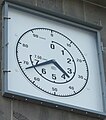
Analog display ( level clock )


The measured values are transmitted to the Bingen Waterways and Shipping Authority , the Southwest Waterways and Shipping Directorate and the Federal Institute for Hydrology (BfG) in Koblenz . There is also an automated telephone announcement that interested people can use to obtain information about the water level and trend at any time. This level announcement can be called up by calling 06131 19429.
history
In 1797 the Erfeld gauge was built. This "original level" is thus the oldest level between Mannheim and Bingen and was the basis for further levels in Gernsheim and Lampertheim (both 1803), Ginsheim (1808), Oppenheim and Mainz (1818), Koblenz (1819), Worms (1819) and Bingen (1829).
The most important Rhine levels for navigation on the Rhine are Konstanz , Rheinfelden , Iffezheim , Maxau , Speyer , Mannheim , Worms , Mainz, Oestrich , Bingen , Kaub , Koblenz , Andernach , Oberwinter , Bonn , Cologne , Düsseldorf , Duisburg-Ruhrort , Wesel , Rees , Emmerich on the Rhine , Lobith , Pannerdense Kop , IJsselkop , Nijmegen Hafen , Tiel , Zaltbommel , Vuren , Krimpen , Dordrecht and level Rotterdam .
High tide and low tide
The zero point of the Mainz Rhine level is 78.38 m above mean sea level (NHN). A water level of 0.00 m does not mean that the Rhine would no longer carry any water at this point. Rather, this point is chosen in such a way that no negative water levels can result at a level of 0.00 m. The actually lowest possible water level is about 40 cm lower.
Equivalent water level
The equivalent water level (GlW) is the water level that occurs when the runoffs along the Rhine are determined to be equivalent. It represents a low water level, which falls below an average of 20 days a year at the respective measuring point. Because of the natural changes in the river bed (erosion), the GLW is set again and again. For the Mainz gauge, the GlW 01.01.2015 of 168 cm applies . This means that the water level does not fall below 168 cm on an average of 345 days a year and that a depth of 210 cm is guaranteed in the fairway .
The mean of the lowest water level values in the years 2000 to 2009 was a water level of 1.83 m. The mean value of all water levels in this period was 3.04 m.
High water mark I

The high water mark I is reached in Mainz at a water level of 4.75 m. According to the Rhine Shipping Police Ordinance RheinSchPV , high water mark I means that all (with the exception of non-machine-driven) watercraft must stay in the middle of the fairway when descending and in the middle third of the river width when ascending. Suction and waves should be avoided; In any case, the maximum speed, measured on the bank, must not exceed 20 km / h. In addition, there are other regulations that must also be observed.
The mean value of the highest water levels from 2000 to 2009 was 5.58 m.
High water mark II
A water level of 6.30 m corresponds to the high water mark II . When this mark is reached and exceeded, shipping is completely stopped.
The river section relevant for this and for the high water mark I extends from Gernsheim to Eltville .
Historical water levels


Before the Lauterenviertel was filled up, the parts of the city of Mainz near the bank were exposed to the floods of the Rhine almost unprotected. The level of that time can still be seen today in some streets of the old town (e.g. Haenleinsgässchen, Weintorstraße, Heugasse), at the foot of the wooden tower and in parts of Wallaustraße in Mainz Neustadt.
The former ground level recognizable by the wooden tower corresponds to a water level of 5.67 m, the height of the "Graben" square in the southern old town corresponds to a water level of 8.17 m.
With the construction of the Rheinstrasse as a flood dam from around 1886, however, the risk of flooding was averted. The protective walls on the banks of the Rhine between Winterhafen and Zollhafen as well as Rheinstrasse / Peter-Altmeyer-Allee / Rheinallee are only flooded at a water level of 8.30 m and the water can flood the urban area up to 2 m below. The lowest point of this flood protection is at the castle gate in the extension of the Große Bleiche.
High water marks in the wooden tower , the floor corresponds to a level of 5.67 m.

High water marks at the corner of Fischtorstrasse and Rheinstrasse

High water marks at the corner of Fischtorstrasse and Rheinstrasse


It can be clearly seen that the high water marks from the years 1565 to 1845 both in Fischtorstrasse and on the wooden tower are well above the street level of Rheinstrasse (water level 8.30 m). However, due to the regulation of the Rhine upstream from Mainz between 1817 and 1876 , these extreme floods were greatly reduced.
On November 28, 1882, the Rhine rose to 7.95 m. The water flowed into the old town and the garden field in front of it, today's Mainz Neustadt . Rheinstrasse, Holzstrasse, Löhrstrasse, Schlossergasse, Brand and Schlossplatz were flooded. The Rhine rose again in December and January. The governor of Mainz fortress at the time, General Wilhelm von Woyna , helped the severely affected civilian population with his subordinate military. In recognition of this, Woyna was made an honorary citizen of the city of Mainz, and a street in the Neustadt district of Mainz was named after him.
| meter | date | Comments / sources |
|---|---|---|
| 6.30 m | High water mark II. Shipping is discontinued. | |
| 7.93 m | Jan. 5, 1833 | - |
| 7.95 m | Nov 28, 1882 | highest flood to date |
| 6.85 m | Feb 8, 1897 | - |
| 7.33 m | Jan. 16, 1920 | - |
| 1.10 m | Nov 2, 1947 | historical lowest water level at the Mainz gauge |
| 6.94 m | Jan. 18, 1955 | - |
| 7.37 m | Feb. 27, 1970 | - |
| 7.06 m | Apr 13, 1983 | - |
| 7.04 m | May 29, 1983 | - |
| 7.70 m | 29 Mar 1988 | - |
| 7.03 m | Jan. 29, 1995 | - |
| 6.49 m | Jan. 16, 2011 | |
| 6.82 m | 5th June 2013 | - |
In hot and dry years, the water level sank considerably. The historically lowest water level at the Mainz gauge was 1.10 m on November 2, 1947. On December 8, 1962, the water level was only 1.17 m. On October 22, 2018 it was 1.19 m and in 2013 it was 1.21 m. On December 1, 2011, the water level reached 1.40 meters. On October 1, 2009, 1.57 m was measured.
A water depth of around 40 cm is added to the water level in Mainz, depending on the current equivalent water level . This means that in the years mentioned, water depths between approx. 1.50 m and 1.97 m were sometimes only guaranteed.
Since fully loaded cargo ships nowadays have drafts between 2.50 and three meters, unrestricted navigation is only possible at water levels between 2.60 m and 4.75 m.
Web links
- Mainz gauge in the hydrological information system of the Federal Waterways and Shipping Administration
- Level records in Germany
- Undine information platform: Mainz gauge
Individual evidence
- ↑ ELWIS
- ↑ Archived copy ( memento of the original from October 19, 2015 in the Internet Archive ) Info: The archive link was inserted automatically and has not yet been checked. Please check the original and archive link according to the instructions and then remove this notice.
- ↑ Woyna1
- ↑ Woyna2
- ↑ donnerwetter.de
- ↑ Budenheim water sports enthusiasts
- ↑ donnerwetter.de
- ↑ http://www.hochwasser-rlp.de/ As of October 22, 2018 8:00 a.m.
- ↑ http://www.pegelonline.wsv.de/ Status: December 1, 2011 11:30 a.m.
- ↑ Verkehrsrundschau.de
Coordinates: 50 ° 0 ′ 14.1 ″ N , 8 ° 16 ′ 31.4 ″ E