
Theodor Heuss Bridge (Mainz – Wiesbaden)
Coordinates: 50 ° 0 ′ 24 ″ N , 8 ° 16 ′ 37 ″ E
|
|
||
|---|---|---|
 |
||
| use | Road bridge | |
| Convicted | Bundesstrasse 40 | |
| Crossing of | Rhine | |
| place | Mainz - Wiesbaden | |
| construction | Arch bridge with truss arches | |
| overall length | 475 m | |
| width | 24 m | |
| height | 9 m | |
| start of building | 1882 | |
| completion | 1885 | |
| planner | Friedrich von Thiersch | |
| location | ||
|
||

Today's Theodor Heuss Bridge links across the Rhine the district Mainz-Kastel of the Hessian state capital Wiesbaden with the Rhineland-Palatinate state capital Mainz .
Technical specifications
The bridge consists of five two-hinged truss arches (widths of the arches: 87.13 m - 98.96 m - 102.94 m - 98.96 m - 87.13 m). These span between the two bridgeheads over four sandstone pillars.
Construction, expansion and renovation of today's Rhine bridge


Before the construction contract was awarded, a competition was held, which those later involved in the construction won with the working title Pons Palatinus .
The Rhine bridge was built according to plans by the architect Friedrich von Thiersch and the bridge construction engineer Bernhard Bilfinger (the father of Paul Bilfinger ) in the years 1882 to 1885 by the project group Philipp Holzmann / Gebrüder Benckiser . On May 30, 1885, at 11 a.m., a ceremonial inauguration took place, to which the Grand Ducal Ministry of Finance in Darmstadt invited. The construction costs amounted to 3.6 million marks and were to be refinanced within three years through the levied bridge toll (pedestrians: 4 pfennigs, passengers on the horse-drawn tram: 5 pfennigs, pigs, goats: 1 pfennigs, schoolchildren: free). However, the bridge fee was not finally abolished until 1912, after 27 years.
From 1931 to 1934 an extension (including widening from 13.80 m to 18.80 m) was carried out by MAN . The "octroi houses", in which the bridge money had been collected until 1912, and the light pylons were also removed. On March 17, 1945, shortly before the US troops reached the city in World War II , the bridge was blown up by the retreating German troops .
The US Army built a pontoon bridge after taking the city . This existed from March 29, 1945 to April 14, 1945 and served the advance of US troops. As a replacement for the destroyed road bridge, the Alexander-M.-Patch-Brücke served from 1946 to 1950 as an extension of Kaiserstrasse , which was only dismantled in 1963. Colloquially, the people of Mainz called it "Patten Brigg" after the commander of the 3rd US Army , George S. Patton .
The road bridge was rebuilt by the MAN Gustavsburg plant from 1948 to 1950. On May 15, 1950, the bridge was put into operation in the presence of the first Federal President of the Federal Republic of Germany , Theodor Heuss , whose name it bears today.
Between 1992 and 1995, all parts of the structure were completely renovated. The wrought iron arches were exchanged for steel arches . The following companies were involved: Stahlbau Lavis, Thyssen Engineering GmbH (Klönne plant, Dortmund ) and Voest-Alpine MCE from Linz . In addition to the necessary technical and constructive renovations, this general renovation also took into account the preservation of monuments by attempting to maintain or restore the original character of the bridge. A new chain railing that separated the street from the pedestrian walkways was removed after an accident in which a cyclist was fatally injured. The renovation costs amounted to 139.5 million D-Marks, according to today's purchasing power approx. 100 million euros.
The Theodor-Heuss-Brücke is part of Bundesstrasse 40. According to the Federal Trunk Road Act (Section 5), the road construction load is incumbent on the cities of Mainz and Wiesbaden, since the relevant number of 80,000 inhabitants is exceeded by both cities. Therefore, both cities have signed a contract with the Wiesbaden Office for Roads and Transport for management. 62.8% of the maintenance costs are borne by Wiesbaden and 37.2% by Mainz, since two thirds of the bridge belongs to Wiesbaden and one third to Mainz. The bridge is checked according to DIN 1076 .
The highest point of the road surface is at 100.25 meters above sea level and is therefore the highest point that has to be overcome during the Gutenberg Marathon .
Traffic management
The Theodor Heuss Bridge is the only direct road bridge connection between the two state capitals that is not part of a motorway. It has four lanes and has wide combined pedestrian and cycle paths on both sides. With a few exceptions, however, it has been closed for heavy goods traffic from 7.5 t since the 1990s, so that the bridge is now mainly used by cars and buses as well as in local public transport .
The development on the Mainz side is the reason that the traffic management here is unusual. A solution like the one on the Kastel side, where a large high roundabout regulates the approaching and departing traffic on the bridge, is not possible on the left side of the Rhine, as the buildings of the Rhineland-Palatinate state government are too close to the river. In the direction of Mainz, this creates the impression of driving directly into the building .
The departure from the bridge leads to the northwest towards Neustadt, to the southeast towards the old town and Weisenau, the vehicles have to make a 180 ° turn after the departure. Traffic from Mainz is directed onto the bridge from the south-east; vehicles from the north-west must first pass the bridge and then after a 180 ° turn onto the bridge. Coming from the south-east of Rheinstrasse, the right-hand lane leads straight under the bridge; the left-hand lane must be chosen to access the bridge.
On the Kastel side, three feeder roads are connected, so that on July 7, 1960, the “Hochkreisel” created a high-performance connection that also crosses the railway line that runs there.

Until the 1950s, the trams of the Mainz and Wiesbaden transport companies still crossed the bridge. Five lines ran every 15 minutes, so that on average there was one trip every three minutes in each direction. It was the lines:
- 2 University – Kastel train station
- 6 Mainz Hbf – Wiesbaden (old) main post office (today Rhein-Main-Hallen )
- 7 Mombach – Kostheim location
- 8 Bretzenheim – Kostheim settlement
- 9 Mainz Hbf – Schierstein
In addition to the Theodor-Heuss-Brücke, in the Mainz-Wiesbaden area there are also the two motorway bridges of the A 60 ( Weisenauer Brücke ) and the A 643 ( Schiersteiner Brücke ) as well as the Kaiserbrücke and the Südbrücke for rail traffic . In addition to the Theodor-Heuss-Brücke, only the Schiersteiner and Kaiserbrücke bridges directly connect Wiesbaden and Mainz, while the Weisenauer Brücke and the Südbrücke begin and end on the Hessian side south of the Main in the area of the city of Ginsheim-Gustavsburg. The next Rhine bridges are upstream near Worms and downstream near Koblenz .
Historical predecessors
Roman bridges
Main article: Roman Bridge (Mainz)
The Romans had built a bridgehead with the Castellum on the right bank of the Rhine. First of all, a pontoon bridge was built in the early years of the offensive . Around the year 27 AD, a solid bridge replaced this forerunner. This consisted of at least 21 stone pillars 18 meters long and 7 meters wide and had a 12 meter wide multi-lane carriageway.
The remains of this Roman Rhine bridge, which stood above today's Theodor-Heuss-Brücke, are evidence of the high engineering art of the Romans. Its supporting pillars were composed of large stone blocks. These sat on oak stakes rammed into the river bed, reinforced with iron pole shoes .
At the moment, only a bronze relief on the Theodor Heuss Bridge, about 100 meters upstream from the actual location, gives an idea of the first permanent Rhine bridge.
Early medieval wooden bridge
Main article: Charlemagne's Rhine Bridge
Around the year 813 under Charlemagne, another permanent bridge was built between Mainz and Kastel. However, it burned down, although the sources are not entirely in agreement whether this happened shortly after the opening or the night before the opening.
Modern times
Until the construction of the Theodor-Heuss-Brücke there was a ship bridge over the Rhine from 1661 . The increasing shipping traffic on the Rhine made it necessary to replace this construction, which led to the construction of the bridge.
Picture gallery

The bridge on the opening day, 1885

Illumination at Luminale 2006
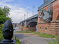
View from the lower bridgehead in Kastel.

Plaque commemorating the construction and renovation of the bridge.

View into the steel structure at the Kastel bridgehead

Theodor-Heuss-Brücke photographed from Mainz in the morning


Temporary events and installations
One morning in 1997, the bridge was completely closed for filming “Das Mainz Lied” on SWF by Lars Reichow at the piano.
From 22 to 23 April 2006 was part of the Luminale , the illumination of the Theodor Heuss Bridge instead. Different colored lamps were attached to the underside of the bridge, which let the bridge construction appear in a different light.
literature
- Wolfgang Wenzel: building full of glamor and magic - the permanent connection across the Rhine was opened 125 years ago. Rhein Main Presse, Allgemeine Zeitung Mainz, May 29, 2010, p. 3.
See also
- History of the city of Mainz
- other Theodor Heuss bridges are u. a .:
- Theodor Heuss Bridge (A 6) near Mannheim
- A bridge in the course of the federal highway 4 R near Nuremberg
- Theodor Heuss Bridge (Düsseldorf) in Düsseldorf
Web links
- Information from the city of Mainz about the historic Roman Rhine Bridge
- Pictures of the historic Rhine bridge
- Historic Mainz: Theodor Heuss Bridge
- Picture of the general renovation 1992–1995
Individual evidence
- ^ The competition to obtain drafts for a permanent road bridge over the Rhine near Mainz. Centralblatt der Bauverwaltung, May 14, 1881, pp. 61f., Accessed on December 7, 2012.
- ↑ Competition for the Rhine bridge near Mainz. Centralblatt der Bauverwaltung, April 30, 1881, p. 44, accessed on December 7, 2012.
- ↑ Archive link ( Memento of the original from June 8, 2015 in the Internet Archive ) Info: The archive link was inserted automatically and has not yet been checked. Please check the original and archive link according to the instructions and then remove this notice.
- ↑ Friedrich Standfuß, Joachim Naumann: Bridges in Germany. Deutscher Bundes-Verlag, Cologne 2006, ISBN 978-3-935064-41-5 , p. 46.
- ↑ This figure was based on the template: Inflation determined and relates to the previous January.
- ↑ Friedrich Battenberg, Eckhart G. Franz (Ed.): The Chronicle of Hessens. Chronik-Verlag, Dortmund 1991, ISBN 3-611-00192-9 .
|
The next bridge upstream: Charlemagne's Rhine Bridge / Roman Bridge (Mainz) (destroyed) South Bridge (Mainz) |
Bridges over the Rhine |
The next bridge downstream: Alexander-M.-Patch-Brücke (destroyed) Kaiserbrücke (Mainz) |