
Theodor Heuss Bridge (Düsseldorf)
Coordinates: 51 ° 14 ′ 49 ″ N , 6 ° 45 ′ 35 ″ E
|
|
||
|---|---|---|
.JPG) |
||
| Convicted | Bundesstrasse 7 | |
| Crossing of | Rhine | |
| place | Dusseldorf | |
| construction | Cable-stayed bridge | |
| overall length | 1270.9 meters | |
| width | 27.1 meters | |
| Longest span | 260 meters | |
| opening | 1957 | |
| planner | Fritz Leonhardt | |
| location | ||
|
||

The Theodor-Heuss-Brücke is a Rhine bridge in Düsseldorf , which is the first cable-stayed bridge in Germany and was opened to traffic in 1957. The federal highway 7 crosses the Rhine over this bridge . Before the airport bridge was built, it was the most northerly Rhine bridge in Düsseldorf, which is why it was not only popularly called the North Bridge until January 1964, but also officially .
location
As one of seven Rhine bridges in the Düsseldorf city area, the Theodor-Heuss-Brücke crosses the Rhine at kilometer 746. On the right bank of the Rhine, the bridge ends in the Golzheim district and on the left bank of the Rhine in Niederkassel . The Theodor Heuss Bridge, together with the neighboring Oberkassel Bridge, about two kilometers away upstream, and the Rheinknie Bridge another kilometer behind it, form the original Düsseldorf bridge family , which has significantly influenced the development of this type of bridge worldwide for many years. The next Rhine bridge downstream is the airport bridge, about six kilometers away and opened in 2002 .
description
The actual cable-stayed bridge is 476 meters long. A 333 meter long elevated road connects to it on the right bank of the Rhine via Cecilienallee / Rotterdamer Strasse and Kaiserswerther Strasse. On the left bank of the Rhine, it is supplemented by a 462 meter long foreland bridge over the flood bed, which after the Niederkasseler Deich crosses the Kaiser-Friedrich-Ring and then ends on an artificial ramp. The main opening over the Rhine has a span of 260 meters, the two lateral openings of 108 meters each.
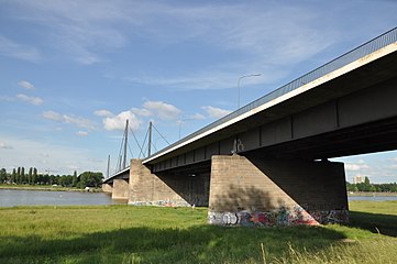
The bridge has two lanes in each direction of travel as well as a pedestrian and bicycle path parallel to it on the outside. The bridge deck, including the railings, is 27.10 meters wide. Of this, 15 meters are accounted for by the four lanes and their middle separating ramp. The pylons , the anchoring of the ropes and the lighting masts are located on a 1.75 meter wide strip on both sides of the roadway . This is followed by 4.05 meter wide strips for the sidewalks and bike paths. The steel bridge deck is constructed as an orthotropic plate with cantilevered sidewalks and bike paths, in the shade of which the 3.30 m high main girders should appear as slim as possible.
One pylon stands directly on the right bank on the outer edge of the curve described by the Rhine, the other pylon stands in front of the left bank in the shallow water of the inside of the curve. Both pylons consist of massive concrete pillars below the bridge deck, which take up almost its entire width. Above the bridge deck, they each consist of two slender, 44-meter-high, free-standing posts that taper slightly towards the top and are not stiffened by crossbars. From these stems made of riveted sheet steel, three parallel steel cables are stretched to the bridge deck in both directions of travel.
The Theodor-Heuss-Brücke connects the northern and eastern urban areas of Düsseldorf, the exhibition center and the airport with the districts of Oberkassel , Niederkassel, Heerdt , Lörick on the left bank of the Rhine , the Seestern office area and the Büderich district of Meerbusch . The federal highway 7 runs over it , which together with the federal highway 1 in Düsseldorf closes the gap between the right and left bank of the A52 and therefore connects Düsseldorf with Essen and the Ruhr area as well as with Kaarst , Mönchengladbach and the Lower Rhine region.
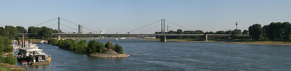
View of the Theodor-Heuss-Brücke, in front on the left the yacht harbor of the Düsseldorf Yacht Club , on the right in the background the Rheinturm
Theodor Heuss Bridge with fore bridge

Pylon of the bridge

.JPG)
.JPG)
history
In 1952, the Düsseldorf City Planning Office, headed by the architect Friedrich Tamms, commissioned a group around the civil engineer and structural planner Fritz Leonhardt to design the north bridge. Inspired by the treatises published by Franz Dischinger in 1949, Leonhardt created the design of a cable-stayed bridge with pylons in the usual frame shape and tufted cables attached to the tip. Tamms found the pylon frames too cumbersome, because free-standing, slim stems would have to be sufficient for the low wind loads. With an oblique view of the bridge, the tufted ropes would overlap in an unsightly way, which is why Tamms asked for a harp-shaped, parallel arrangement of the ropes, with which there can be no optical overlap. Leonhardt revised his design in the way that Tamms wanted.
On October 8, 1953, the city decided to accept this revised draft, on the basis of which the construction work was subsequently tendered, awarded to the steel construction company Hein, Lehmann & Co. AG based in Düsseldorf-Oberbilk , and started on August 21, 1954. During the more than three years of construction, there was an incident: In March 1956 a section of the bridge fell into the Rhine while it was being installed. On December 19, 1957, the bridge was opened to traffic. It was what Tamms wanted, except for one thing: the street lighting department had erected the usual curved whip masts, while Tamms had put up straight masts to line up with the vertical pylons. Tamms avoided asking for the masts to be changed.
The north bridge was part of a more extensive road construction project, the aim of which was to relieve the Düsseldorf city center from the increasing east-west through traffic in the course of federal highway 7 . The connection from the bridge ramp on the right bank of the Rhine to the Mörsenbroicher Ei has been expanded and rebuilt several times since the 1950s. On November 3, 1959, the 9.5-kilometer-long access to the bridge on the left bank of the Rhine , which began on Kevelaerer Straße (then B 9 ) in Heerdt and was then known as the Düsseldorf city motorway , was opened to traffic. Since then, Bundesstraße 7 has taken its current route in the Düsseldorf city area. The surveying work was headed by Heinz Günther Henneberg , who made this the subject of his doctoral thesis submitted in 1962 .
The bridge was given its current name on January 31, 1964, when it was named after Theodor Heuss , the German President and Düsseldorf honorary citizen, who died on December 12, 1963 from 1949 to 1959 .
The Theodor-Heuss-Brücke had to cope with a traffic volume that had grown to 100,000 vehicles per day by 2002 and thus became more and more a “bottleneck”. Since the opening of the airport bridge and the associated closure of the last gap in the Düsseldorf motorway ring, the traffic situation on the bridge has eased again.
In November 2019 the bridge was closed for vehicles over 30 tons total weight due to "load deficits".
Web links
literature
- Paul Ernst Wentz: Architectural Guide Düsseldorf , Droste Verlag, Düsseldorf 1975, object no. 75 A
Individual evidence
- ^ Holger Svensson: Cable-stayed bridges. 40 years of experience worldwide . Ernst & Sohn, Weinheim 2011, p. 60
- ^ Senior City Director of the State Capital Düsseldorf (Ed.): Bridges for Düsseldorf 1961–62 . Springer, Berlin approx. 1963, p. 41
- ↑ a b c Fritz Leonhardt: Builders in a revolutionary time. Memories. 2nd ed. Dt. Verl.-Anst., Stuttgart 1998, ISBN 3-421-02815-X , pp. 119-121
- ^ Franz Dischinger: Suspension bridges for the heaviest traffic loads . In: Civil engineer , Springer Verlag, Düsseldorf; (I): March 1949, No. 3, pp. 65-75; (II): April 1949, No. 4, pp. 107-113
- ^ State capital Düsseldorf : Düsseldorfer Stadtchronik 1954
- ^ State capital Düsseldorf : Düsseldorfer Stadtchronik 1959
- ↑ Heinz-Günther Henneberg: "The surveying work during the construction of the north bridge". In: Landeshauptstadt Düsseldorf (ed.), Nordbrücke Düsseldorf (1958), pp. 140–154.
- ^ State capital Düsseldorf : Düsseldorfer Stadtchronik 1964
|
The next bridge upstream: Oberkasseler Bridge |
Bridges over the Rhine |
The next bridge downstream: the airport bridge |