
Mainz-Kastel
 district of Wiesbaden |
|
|---|---|
  |
|
| Coordinates | 50 ° 0 '35 " N , 8 ° 17' 4" E |
| height | 82.5– 138 m above sea level NN |
| surface | 9.51 km² |
| Residents | 13,328 (Dec. 31, 2019) |
| Population density | 1401 inhabitants / km² |
| Proportion of foreigners | 27.6% (Dec. 31, 2019) |
| Incorporation | Jul 25, 1945 |
| Post Code | 55252 |
| prefix | 06134 |
Administration address |
St. Veiter Platz 1 55246 Mainz-Kostheim |
| Website | www.wiesbaden.de |
| politics | |
| Mayor | Christa Gabriel ( SPD ) |
| Deputy Mayor | Hartmut Bohrer (ON AKK) |
| Source: State Capital Wiesbaden: EWZ - HW on December 31, 2019 ( Memento from February 3, 2020 in the Internet Archive ) | |

Entrance sign until 2006

today


Mainz-Kastel [kasˈtɛl] is a district of the Hessian capital Wiesbaden .
Kastel is a historical bridgehead of the Rhineland-Palatinate state capital Mainz on the right bank of the Rhine opposite the old town of Mainz and is connected to it by a road bridge. Kastel is about a kilometer below the current confluence of the Main and the Rhine. Kastel has belonged to Mainz repeatedly in its long history, it was formally incorporated on April 1, 1908. On July 25, 1945, Kastel was following the borders of the occupation zones after the Second World War (Kastel was in the American, Mainz in the French occupation zone) Order of the American occupying power subordinated to "fiduciary administration" by the city of Wiesbaden and has belonged to the Hessian state capital since then.
The newly founded or formed federal states then oriented themselves to the borders of the occupation zones, so that Kastel, as a Wiesbaden district, belongs to Hesse. Kastel was one of the six districts of Mainz on the right bank of the Rhine , which were separated from Mainz in this way. In three parts of the city (in addition to Kastel also in Amöneburg and Kostheim ), this is still the subject of sometimes violent local patriotic debates (see also: AKK conflict ). Many Kastelians do not feel like Wiesbadeners, but tend to Mainz, which apart from the administrative affiliation also corresponds to the reality of life, since the Wiesbaden city center is around 10 km away, the Mainz residents, on the other hand, directly on the other side of the Rhine. As agreed in a fourteen-point paper between the two mayors from Mainz and Wiesbaden in 1945, the three districts assigned to Wiesbaden (Amöneburg, Kastel and Kostheim) retained the name “Mainz-…”. A curiosity are the entrance signs , which read: "State capital Wiesbaden district Mainz-Kastel" (see pictures). On the other hand, many residents feel like Hesse (Mainz also belonged to the Grand Duchy of Hesse or the People's State of Hesse from 1816 to 1945 , cf. Rheinhessen ) and can not identify with Rhineland-Palatinate .
geology
Kastel is located in the Rhine Valley and has a natural elevation in the form of a Rhine terrace towards Fort Biehler . The soil in Kastel is generally considered to be very fertile, after a few meters you usually come across layers of sand several meters thick on the plain.
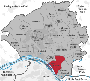
Neighboring districts, neighboring municipality
Kastel borders the neighboring districts of Amöneburg , Kostheim , Delkenheim and Erbenheim with land borders and the city of Mainz with a river border in the Rhine .
history


The northernmost Roman arch of honor that has been found so far is located in Kastel . It was probably erected in honor of Germanicus after his death in 19 AD. However, a map from 1645 shows a "Traiani munumentum" in the area of Kastel, thus referring to the Roman emperor Trajan . It is unclear whether this is the same building, and there is no clear evidence for whom the arch of honor was actually built.
Kastel was founded around 11 BC. At this time, the Romans built a pontoon bridge over the Rhine and fortified the bridgehead on the right bank of the Rhine with a fort ( Castellum Mattiacorum , fort in the land of the Mattiakers ). The wooden structure was replaced by a stone bridge around AD 71, which could be used until AD 406. The oldest view of the city of Mogontiacum and Castellum Mattiacorum can be seen on the so-called Lyons lead medallion , made around 300 AD , which was found in 1862 in the Sâone near Lyons. There was also a large villa rustica in the district of Kastel (in the area of today's Petersweg Ost industrial park). In addition, a short time apart from the actual fort, there was a wooden fort (probably a training fort) in the 2nd half of the 2nd century, which was excavated in the summer of 2009. Two Roman Leugensteine were found on the former Roman military road in 1896 .
A brief restoration of the Rhine bridge by Charlemagne was destroyed by fire around 813 AD. The old roads Via Regia to Wismar and the Antsanvia to Eisenach begin in Kastel. Only a millennium later did a bridge again lead from Kastel to the Mainz old town directly opposite , today's copy is called Theodor-Heuss-Brücke and is part of the federal highways 40 and 455 . Over the centuries, however, the name "Steinern Straße" has been retained, which refers to the cobbled road laid out by the Romans and whose course is still largely identical to the original route. in other districts this street is also called Elisabethenstraße .
In the Middle Ages, Kastel played a rather insignificant role. It was burned down several times.
In 1666, over half of the population of Kastel was killed by the plague . Around the Catholic Church “St. Georg “a so-called plague wall was built to contain the disease. Behind it, the sick were cared for and the deceased were buried around the church.


In the years from 1792 onwards, Kastel was fortified as a bridgehead by the French Revolutionary Army under General Custine , later by Napoleon, for the first time since Roman times and further expanded as a fortress of Austria and Prussia from 1816 ( Federal fortress Mainz , Fort Grand Duke of Hesse ). An assignment contract for Kastel and Kostheim from 1806 between the French Empire and the Principality of Nassau-Usingen regulated an assignment to the city of Mainz. After the siege of Mainz in 1814 , Kastel was first administered as district director by Mainz mayor Franz Freiherr Gedult von Jungsfeld on May 18 . In 1839 Kastel was connected to one of the first German railways, the Taunus Railway from Frankfurt am Main via Höchst and Kastel to Wiesbaden . After 1866 Kastel was garrison of the Kgl. Prussian Army . The 2nd Nassau Pioneer Battalion No. 25 was located here in the mudra barracks that still exist today . Also in the former Archduke Wilhelm barracks were the Kurhessian Pioneer Battalion No. 11 and the 1st Nassau Pioneer Battalion No. 21 , in the artillery barracks parts of the 2nd Nassau Field Artillery Regiment No. 63 Frankfurt and the 1st Nassau Regiment Field artillery regiment No. 27 and in the Reduit the 2nd Nassau Infantry Regiment No. 88 as well as two battalions of the Fusilier Regiment "von Gersdorff" No. 80 in the Gersdorff barracks . Through the peace treaty of 3 September 1866 between Prussia and Hessen-Darmstadt, "all [...] parts of the area north of the Main [...]" became Hessen-Darmstadt, including Kastel and Kostheim, in contrast to the Mainz district on the left bank of the Rhine , Part of the North German Confederation , which then became part of the German Empire in 1871.
After the conclusion of an incorporation contract, the then independent city of Kastel was assigned to a district of Mainz on April 1, 1908, and in 1945 due to the demarcation of the occupation zones by the American authorities of the city of Wiesbaden.
Kastel was almost completely destroyed by British and American bombing raids on September 8th and 9th, 1944. The actual bomb target, the "Heereszeugamt" In der Witz, which was intended as the main target of the Allied military operations, was also affected. The English viewed the destruction of the supply depot as a partial success. However, the main load of the bombs fell into the old town center due to the weather and caused great damage there. The number of victims in the attack on September 8, 1944 was given as 430 dead.
Today Kastel no longer consists only of the old town center around Mainzer Strasse and the houses along the Rhine, but has extended beyond the 21 hectare “AFEX site” (Air Forces Europe Exchange) in the north of the town center, which is still used by the military developed. The largest new development areas, the Krautgärten and An der Helling, have only emerged since the mid-1990s.

Kassel, Cassel, Casel, Caßel or Castel are also passed down as earlier place names.
Religions
Against the background of the historical development, the Catholic Christians are strongly represented, whereby a Protestant community has been established since the 1860s. Kastel has a Catholic and a Protestant church as well as a Catholic community center in the herb gardens.
Mainz-Kastel is the seat of the European Archdiocese of the Old Churches of the East .
Corresponding to the population share of 19.7 percent of foreigners, there are various other religious affiliations, with Muslims being the next largest group after Catholics and Protestants. The next mosque is not far from the border in the neighboring district of Kostheim.
Population development
According to the latest published statistics from the Office for Elections, Statistics and Election Research, Kastel was home to 12,409 people in 5,843 households at the beginning of 2013. Since 2003, Kastel has grown by around 900 people.
politics
Election results for the local council
Since 1972, as part of which is local elections in Hesse and the town council of the local district voted Mainz-Kastel. The individual election results are summarized below.
| CDU | SPD | ON BATTERY | FDP | REP | voter turnout | |
|---|---|---|---|---|---|---|
| 2016 | 25.6 | 38.1 | 25.6 | 10.6 | - | 35.8 |
| 2011 | 28.0 | 44.0 | 21.6 | 6.3 | - | 33.5 |
| 2006 | 31.0 | 42.4 | 17.7 | 4.8 | 4.2 | 33.8 |
| 2001 | 28.9 | 39.7 | 20.8 | 3.0 | 7.5 | 44.6 |
| 1997 | 27.1 | 40.0 | 28.6 | 2.9 | - | 56.1 |
| 1993 | 27.4 | 41.9 | 24.8 | 6.0 | - | 60.0 |
| 1989 | 30.7 | 50.7 | 12.6 | 6.0 | - | 66.9 |
| 1985 | 33.6 | 50.2 | 8.4 | 7.8 | - | 63.4 |
| 1981 | 43.6 | 46.1 | 0.0 | 10.3 | - | 63.2 |
| 1977 | 44.9 | 47.4 | 0.0 | 7.7 | - | 67.3 |
| 1972 | 36.7 | 57.6 | 0.0 | 6.7 | - | 72.5 |
This resulted in the following allocation of seats:
| CDU | SPD | ON BATTERY | FDP | REP | total | |
|---|---|---|---|---|---|---|
| 2016 | 4th | 6th | 4th | 1 | - | 15th |
| 2011 | 4th | 7th | 3 | 1 | - | 15th |
| 2006 | 5 | 6th | 3 | 1 | - | 15th |
| 2001 | 4th | 6th | 3 | 1 | 1 | 15th |
| 1997 | 4th | 6th | 5 | - | - | 15th |
| 1993 | 3 | 4th | 3 | 1 | - | 11 |
| 1989 | 3 | 6th | 1 | 1 | - | 11 |
| 1985 | 5 | 8th | 1 | 1 | - | 15th |
| 1981 | 6th | 7th | - | 2 | - | 15th |
| 1977 | 7th | 7th | - | 1 | - | 15th |
| 1972 | 5 | 9 | - | 1 | - | 15th |
Mayor
Christel Gabriel ( SPD ) has been the mayor since the 2011 local elections . There is political cooperation in the local advisory board between the SPD and the AUF AKK (Working Group Environment and Peace Amöneburg, Kastel and Kostheim).
| time | Surname | Political party |
|---|---|---|
| 1977 - November 1978 | Joachim Schäfer | CDU |
| December 1978–1982 | Gregor Wesser-Krell | FDP |
| March 1982-1991 | Bernhard Borg | SPD |
| 1991-1993 | Rose-Marie Kuenz | SPD |
| 1993-1997 | Heinz-Erich Krone | CDU |
| 1997-2001 | Hartmut Bohrer | ON BATTERY |
| 2001-2006 | Heinz-Erich Krone | CDU |
| 2006-2011 | Margot Schäfer | SPD |
| 2011– | Christa Gabriel | SPD |
coat of arms
Blazon : "A seven-ribbed silver shell in blue ."
The shell in the Castel coat of arms can be traced back to a Jacob brotherhood. A great Way of St. James from the east of the empire met the Rhine in Kastel, as the bridge provided an opportunity to cross the river. This coat of arms was first used in the 17th century, at that time with the Mainz wheel .
Culture and sights
Museums
In the Reduit , the Castellum Museum of the Society for Local History Kastel e. V. , and the Roman arch of honor in the Große Kirchenstrasse near the Catholic parish church of St. Georg can be viewed. The Kastel rafting museum is located in the "Bastion Schönborn", near the Reduit .
Cultural characteristics
The various carnival clubs in Kastel are worth mentioning, of which the KCK is one of the four organizers of the television session, which is broadcast nationwide on the Friday before the carnival weekend. In addition, every year, usually in the second half of August, the "AKK Culture Days" take place, during which many smaller cultural events, often with a local reference or by local artists, are offered. Furthermore, the "Meeting of Styles" takes place annually in Mainz-Kastel, where graffiti sprayers from all over the world meet.
Buildings
Striking in Kastel are the catholic parish church of St. Georg, which is clearly visible from the Theodor-Heuss-Brücke, and the not so obvious, but architecturally polarizing church of the evangelical redeemer community.


On the banks of the Rhine is the "all-round defense system" Reduit , which was built between 1830 and 1832 to secure the floating bridge over the Rhine as a fortress of the German Confederation. The ship bridge was built by the Elector of Mainz Johann Philipp von Schönborn after the end of the Thirty Years' War . A fortification of the fortress serving to protect the flanks was named after this: the bastion of Schönborn .
In the north of Kastel, on Boelckestrasse near the "Fort Biehler" settlement, is the Erbenheimer Warte guard tower, which was built between 1492 and 1497 by order of the Archbishop of Mainz, Berthold von Henneberg , a round tower with a pointed stone roof and machicolation , which belonged to the former Mainz Landwehr , which was built to protect against raids by robber gangs and surrounded "Castel" with ditches and formerly four guard towers.
The former fortress " Fort Biehler " is located in the immediate vicinity of the waiting tower . This was built from 1880 to 1884 under the name "Fort Petersberg" and was about half the size of the old town center of Kastel. After the First World War, the area was taken over by the French and sold to the Dyckerhoff company in 1930 . The Dyckerhoff company left parts of the fort to the city of Mainz so that the unemployed could demolish the buildings and build houses from them - larger parts of the houses in today's settlement are made of this broken material. After the Second World War , the area was taken over by the American occupying forces, which filled in large parts of the area. Today the area is owned by the Federal Republic of Germany and is occasionally used for disaster control exercises; it is still not accessible to the public.
Parks
There is a small zoo in Kastel (behind the Petersweg industrial park).
Sports
In the early 1980s Kastel was taken over by the FVgg. Kastel 06 is also known nationwide in the sporting sector. Due to its location on the Rhine, Kastel offers excellent water sports in the Kasteler Ruder- und Kanu-Gesellschaft 1880 e. V. (rowing racing, rowing hiking, canoeing, canoeing, tennis, camping). The two neighboring clubs TG Kastel 1886/54 and TSG Kastel 1846 are worth mentioning . At TG Kastel, in addition to the athletics and gymnastics department - athletics from the club took part in the German all-around championships in 2014 and 2015 - a strong handball department has developed, while TSG Kastel today is primarily characterized by its strong football division .
Regular events
In the "fifth season" there are always various meetings of the carnival clubs, with the highlight on Shrovetide Saturday being the storming of the local administration (located in Kostheim) and the subsequent move through Kastel and Kostheim (in recent years around 10,000 spectators have always been estimated, more than 20,000 visitors were counted in 2011). In the summer (usually in June) the Kastel rattle festival takes place, the traditional lantern parade on St. Martin's Day and the St. Nicholas market on St. Nicholas' Square in the herb gardens.
Since 2008, the Advent Village has also taken place in the Reduit towards the end of the year (end of November / beginning of December).
economy
There are no large industrial companies in Kastel itself. The Metro , a wholesale market of the company of the same name, which sells exclusively to commercial customers, is known far beyond the borders of Kastel . There are also various small and medium-sized companies in Kastel, and the Petersweg industrial area has been under development for many years, where, in addition to a number of businesses, the "Wiesbadener" (postcode 65 ...) letter center is also - a certain paradox, since Kastel is supplied by mail via Mainz Has.
media
Kastel is located since 1980 the station Mainz-Kastel , a guyed transmission tower of the SWR for the spread of FM broadcasts, since the completion of a new building in 2014 with a height of 170 meters.
Public facilities
The Wiesbaden fire station 2 of the professional fire brigade is located in Kastel , which, thanks to its convenient location in terms of traffic, makes the entire southern area of Wiesbaden quickly accessible in addition to AKK. The second police station was also located in Kastel for a long time (in the building of the former local administration "In der Witz"), but was relocated to Kostheim in the summer of 2013 due to the enormous lack of space .
education
In Kastel itself there is only the Gustav Stresemann School with its branch of the Pavilion School (elementary school). There are also the Krautgartenschule (elementary school), whose school district also includes the Kastel area, and the Wilhelm-Leuschner-Schule (integrated comprehensive school) - albeit in the Kostheim area.
traffic
_4.6.2010.JPG)
Streets
Kastel is very conveniently located on the federal highways 40 , 43 and 455 , has the autobahn 671 as a quasi-bypass road and, thanks to its proximity to the supraregional highways 60 and 66, can also be easily reached from the international connections of the motorways 3 and 5 . In the course of Bundesstraße 40 there is also one end of the Theodor-Heuss-Brücke to Mainz in Kastel. In the area of Boelckestrasse (B 455) as a connection between Mainz city center and the motorways 671 and 66 as well as Wiesbaden, due to the high traffic density and frequent traffic jams, this leads to a high burden on the population in this area, while the rest of Kastel benefits from the good connections .
Bicycle traffic
Kastel is connected to the Rhine Cycle Route , which runs as one of the European EuroVelo routes from the source to the mouth of the Rhine.
railroad
The Taunus Railway reached Mainz-Kastel as early as 1839 . First the section to Wiesbaden was put into operation in March 1840, operations on the entire route to Frankfurt began in April 1840. From 1861, the Mainz – Kastel trajectory ensured rail traffic to Mainz for two years before the south bridge was built. The route of the Taunus Railway through Kastel is the link between the right-hand Rhine route , which is mainly used by goods traffic, and the freight stations in the Frankfurt area and in Bischofsheim . The frequency of the trains is so high that the line was included in the federal noise abatement program.In December 2009, work began to erect noise barriers on a large section between the Kastel train station and the crossing route of the Mainz bypass line (in the direction of Wiesbaden Ost train station ). The planned construction of the Igelstein connecting curve could lead to a partial shift in freight traffic.
Transportation
In addition to the railway, Kastel used to be accessible by the Wiesbaden tram to Mainz and the tram from Mainz to Kostheim. Today four bus lines (6, 9, 28 and 33) operate in the area around Kastel, which are operated jointly by ESWE Verkehr and Mainzer Verkehrsgesellschaft (MVG) and which connect Mainz and Wiesbaden. Furthermore, the MVG lines 56 and 57, which come from Mainz exclusively serve Kastel and / or Kostheim , two MVG lines (54 and 55), which come from Mainz through Kastel continue to Kostheim and Gustavsburg in the direction of Bischofsheim and Ginsheim, as well as a line (68) that MVG operates jointly with ORN and which runs from Hochheim via Kostheim, Kastel and Mainz to Klein-Winternheim.
In addition to line 6, which is also operated during the day, there is also a line of ESWE Verkehr (N7 from Wiesbaden city center via Erbenheim to Kostheim) and MVG (91 from Finthen via Mainz Hbf to Bischofsheim). On the nights from Friday to Saturday and before Sundays and public holidays, the MVG disco line 99 also runs from Mainz Hbf to the “Euro Palace” disco in the Peter-Sander-Straße industrial park.
shipping
Since the suspension of the ferries to Mainz and the abandonment of rafting on the Main (the raft harbor next to the Maaraue largely belonged to Kostheim), Kastel has no longer been of any importance for shipping. In the course of a re-demarcation in the mid-1990s, the water police station on the tip of the Maaraue also came to Kostheim, so that Kastel is no longer relevant in this regard either.
Curiosity
The mail center for postal area 65 (Wiesbaden) is located in Mainz-Kastel, although Kastel itself belongs to postal region 55 (Mainz region based in Mainz-Hechtsheim ). The letter center 65 is thus outside its own area of responsibility, because Kastel and Kostheim receive the mail from Mainz. For this reason there is also a separate postcode for mail to the letter center with 65212, as these mailings do not make the detour via Mainz. The neighboring district of Mainz-Amöneburg , on the other hand, is affiliated to the postal region 65 and also uses the Wiesbaden area code 0611.
Personalities
sons and daughters of the town
- Rolf Braun (1929–2006), German KCK fastnaut and meeting president
- Adolphus Busch (1839–1913), Anheuser-Busch , master brewer
- Adam Diehl (1810–1880), actor
- Lorenz Diehl (1871–1948), politician, General Secretary of the Center Party in the Grand Duchy of Hesse
- Kurt Flasch (born March 12, 1930), German historian of philosophy, specializing in the philosophy of late antiquity and the Middle Ages
- Philipp Haas (1854–1903), editor and politician
- Oskar Heinroth (1871–1945), zoologist, founder of comparative behavioral research
- Pascal Hens (* 1980), German national handball player
- Bruno Hübner (* 1961), German football official
- Horst Janson (* 1935), German actor
- Jean Krämer (1886–1943), German architect
- Edith Schultze-Westrum (1904–1981), German actress
- Wilhelm Westenberger (1903–1980), German politician (CDU), Minister of Justice of Rhineland-Palatinate
- Fritz Wichert (1878–1951), art historian, director of art galleries and art colleges
Personalities who have worked on site
- Edmund Heusinger von Waldegg (1817–1886), inventor of the express train car
literature
- Documents
- Picture by Kastel from JF Dielmann, A. Fay, J. Becker (draftsman): FC Vogel's panorama of the Rhine, pictures of the right and left banks of the Rhine. Lithographic institute FC Vogel, Frankfurt 1833
- Picture 2 from Kastel, ditto
- Ernst & Doris Probst: 6000 years of Kastel . From the stone age to the 21st century. CreateSpace Independent Publishing Platform, Leipzig (?) 2018, ISBN 978-1-72932-222-2 (694 pages).
Web links
- Official website of the Mainz-Kastel district of the Hessian capital Wiesbaden
- Literature about Mainz-Kastel in the Hessian Bibliography
- Election results since 1946
- Society for local history Kastel e. V.
- Homepage of the Kasteler Tierpark
Individual evidence
- ^ Eike-Christian Kersten: Mainz - the divided city. (Diss.), Regional culture publisher, Ubstadt-Weiher, Heidelberg et al. 2014, p. 52.
- ^ Hans G. Frenz : The Roman arch of honor from Mainz-Kastel, city of Wiesbaden. An imperial monument of the early imperial era apud ripam Rheni . Brochure Landesamt für Denkmalpflege Hessen, 1988, ISBN 3-89822-076-1 .
- ^ Blaeu 1645 - Germaniae veteris typus, accessed June 2, 2011.
- ^ Maria R.-Alföldi : To the Lyon lead medallion. In: Schweizer Münzblätter. 8, 1958, pp. 63-68 (full text) ; Illustration .
- ↑ Wiesbadener Kurier of November 1, 2007 ( Memento of June 5, 2009 in the Internet Archive )
- ^ Frank Lorscheider: Mainz-Kastel - Kurt-Hebach-Str. Excavation of a Roman marching band (2009). Final report. ausgrabungen.org (PDF); Claus Bergmann, Frank Lorscheider: Observations on a military training camp from Roman times in Mainz-Kastel, city of Wiesbaden. In: Monument Preservation and Cultural History. 2010, 3, pp. 7-12.
- ^ Peace Treaty of 1866 on Verfassungen.de, Article XIV, Paragraph 2
- ^ Regulations for the implementation of the electoral law for the North German Confederation, Appendix C., "Directory of constituencies", "III. 2. Grand Duchy of Hesse"
- ↑ Memories of General Eickemeyer by Rudolph Eickemeyer, Frankfurt 1845 p. 174 or https://books.google.com/books/about/Denkw%C3%BCrdheiten_des_Generals_Eickemeye.html?hl=de&id=w7hJAAAAIAAJ ; Horst Reber (Ed.): Goethe: The Siege of Mainz 1793 Causes and Effects, Exhibition Catalog Landesmuseum Mainz March 28 to May 30, 1993, Mainz 1993, ISBN 3-87439-291-0 , Fig. Nos. 46, 50, 57, 60, 61, 66, 71, 74, 76, 77, 78, 80, 83, 84, 86, 87, 90, 91, 97, 112, 113, 114, 115, 1 ...
- ↑ Population in the local districts on December 31, 2012 ( page no longer available , search in web archives ) Info: The link was automatically marked as defective. Please check the link according to the instructions and then remove this notice. (PDF), Office for Strategic Control, Urban Research and Statistics; State capital Wiesbaden; Retrieved January 16, 2013.
- ↑ District profile Kastel 2010 ( Memento of the original from August 18, 2012 in the Internet Archive ) Info: The archive link was automatically inserted and not yet checked. Please check the original and archive link according to the instructions and then remove this notice. PDF 46.6 kB.
- ↑ Allgemeine-zeitung.de Read on January 3, 2015.
- ↑ Allgemeine-zeitung.de Accessed on March 8, 2011.
- ↑ webmaster: EuroVelo 15: from the source of the Rhine to the North Sea - EuroVelo. Retrieved May 15, 2017 .
- ↑ Allgemeine-zeitung.de
- ↑ Allgemeine-zeitung.de Read on March 23, 2013 10:14 am

Inner districts: center | Northeast | Rheingauviertel | Southeast | Klarenthal | West end
Outer districts: Auringen | Biebrich | Bierstadt | Breckenheim | Delkenheim | Dotzheim | Erbenheim | Frauenstein | Hessloch | Igstadt | Kloppenheim | Mainz-Amöneburg | Mainz-Kastel | Mainz-Kostheim | Medenbach | Naurod | Nordenstadt | Rambach | Schierstein | Sonnenberg