
Wiesbaden-Rheingauviertel
 district of Wiesbaden |
|
|---|---|
  |
|
| Coordinates | 50 ° 4 '32 " N , 8 ° 13' 36" E |
| height | 136- 187 m above sea level. NN |
| surface | 2.47 km² |
| Residents | 22,541 (Dec. 31, 2019) |
| Population density | 9126 inhabitants / km² |
| Proportion of foreigners | 25.2% (Dec. 31, 2019) |
| Post Code | 65185, 65187, 65195, 65197 |
| prefix | 0611 |
Administration address |
Schlossplatz 6 65183 Wiesbaden |
| Website | www.wiesbaden.de |
| politics | |
| Mayor | Gabriele Maria Kammerer ( Greens ) |
| Deputy Mayor | Arash Esmaeili Jamali ( SPD ), Roland Hauptstein ( CDU ) |
| Source: State Capital Wiesbaden: EWZ - HW on December 31, 2019 ( Memento from February 3, 2020 in the Internet Archive ) | |
Rheingauviertel, Hollerborn is a district of the Hessian state capital Wiesbaden .
As a residential area in the southwest of the state capital, it was largely built between 1902 and 1908 in the style of historicism .


When Wiesbaden experienced its heyday as a world spa town at the time of the empire and especially at the turn of the century 1900, the emperor went to the spa every year in May and the city had the most millionaires in Germany, there was an enormous population growth (from approx. 33,000 inhabitants in 1870 to approx. 109,000 inhabitants in 1910). This made extensive city expansion necessary. In addition to the extensive villa areas to the east and north, a mostly four-storey closed residential development was built around the Ringstrasse (Kaiser-Friedrich-Ring and Bismarckring), which in a quarter arc from the south-facing main station to the northwest-facing Sedanplatz around the historic center of the city, the so-called Historic pentagon , led. Outside the Ringstrasse, the Dichterviertel emerged in the south , the Feldherrenviertel in the northwest and the Rheingauviertel in between.
The town architect Felix Genzmer , who worked in Wiesbaden from 1881 to 1903, played a decisive role in its design . The richly decorated town houses were built predominantly in the style of historicism and mostly housed manorial town houses with 3.50 m high ceilings, stucco and double doors and often had huge dimensions of up to 200 m². In later years, these apartments were often divided into smaller units for better rentability.
Today in the Rheingauviertel mainly students and young families with a high level of education and middle income live.
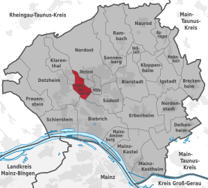
The core area of the Rheingauviertel is bordered in the north by Dotzheimer Straße , in the east by Kaiser-Friedrich-Ring, which is part of the Ringstraße, in the south by Schiersteiner Straße and in the west by Lorelei- or Konrad-Adenauer-Ring, whereby the administrative Rheingauviertel also extends to the west of it, but here has more modern buildings. To the southwest of Niederwaldstrasse (between Karlsbader Platz and Schiersteiner Strasse) there are also more modern buildings from the 1960s. Most streets are designed as avenues and mostly have small front gardens facing the street.
At the western end of Rheinstrasse is the Protestant ring church with its 65 m high twin tower .
A sight on the edge of the core area is the construction workers monument .
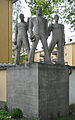
Carl Wilhelm Bierbrauer's “Construction Workers Monument ” on Loreleiring and Oestricher Straße

The cath. Church
“St. Andreas ”in the Rheingauviertel
The ev. Ringkirche forms the north-eastern end of the Rheingauviertel


The quarter owes its name to the naming of its streets. These are all named after places in the Rheingau :
In the core area of the district are:
|
|
Outside the core area are:
|
|
Hollerborn is an old field name and is made up of the terms Holler for elder and born for source .
Election results for the Wiesbaden-Rheingauviertel / Hollerborn local council
Since 1972, the Wiesbaden-Rheingauviertel / Hollerborn local advisory council has been elected at the same time, but independently, with the elections for the Wiesbaden city council (figures in the table in percent).
| CDU | SPD | GREEN | FDP | REP | left | Free voters | ULW | Pirates | voter turnout | |
| 2016 | 22.0 | 31.5 | 26.0 | 9.8 | - | - | - | 8.5 | 2.2 | 39.3 |
| 2011 | 25.1 | 32.1 | 25.4 | 4.6 | 1.9 | 6.9 | - | - | - | 37.0 |
| 2006 | 31.1 | 34.9 | 18.0 | 4.3 | 6.6 | 5.1 | - | - | - | 32.9 |
| 2001 | 31.7 | 36.8 | 16.3 | 9.6 | 5.6 | - | - | - | - | 40.8 |
| 1997 | 32.5 | 41.0 | 21.9 | 4.7 | - | - | - | - | - | 55.2 |
| 1993 | 28.6 | 34.7 | 18.4 | 7.8 | - | - | 10.5 | - | - | 60.6 |
| 1989 | 31.8 | 47.7 | 13.2 | 6.0 | - | - | - | - | - | 66.3 |
| 1985 | 38.8 | 44.5 | 10.6 | 5.7 | - | - | - | - | - | 61.8 |
| 1981 | 47.7 | 38.6 | 6.7 | 7.3 | - | - | - | - | - | 61.3 |
| 1977 | 50.0 | 43.0 | - | 7.0 | - | - | - | - | - | 66.0 |
| 1972 | 38.7 | 52.5 | - | 8.9 | - | - | - | - | - | 71.4 |
The distribution of seats in the Wiesbaden-Rheingauviertel / Hollerborn local advisory board then looks as follows (the five percent hurdle applied until 1997 ):
| CDU | SPD | GREEN | FDP | REP | left | Free voters | ULW | total | |
| 2016 | 3 | 5 | 4th | 2 | - | - | - | 1 | 15th |
| 2011 | 4th | 5 | 4th | 1 | - | 1 | - | - | 15th |
| 2006 | 5 | 5 | 3 | - | 1 | 1 | - | - | 15th |
| 2001 | 5 | 6th | 2 | 1 | 1 | - | - | - | 15th |
| 1997 | 5 | 7th | 3 | - | - | - | - | - | 15th |
| 1993 | 4th | 5 | 3 | 1 | - | - | 2 | - | 15th |
| 1989 | 5 | 7th | 2 | 1 | - | - | - | - | 15th |
| 1985 | 6th | 7th | 1 | 1 | - | - | - | - | 15th |
| 1981 | 7th | 6th | 1 | 1 | - | - | - | - | 15th |
| 1977 | 8th | 6th | - | 1 | - | - | - | - | 15th |
| 1972 | 6th | 8th | - | 1 | - | - | - | - | 15th |
Web links
- Official website of the Rheingauviertel district of the Hessian state capital Wiesbaden
- Wiesbaden in the picture
- Historical views of Wiesbaden
Individual evidence, appendix
In addition to individual references, this appendix provides information on the naming of the streets in the Rheingauviertel.
- ^ To the city of Eltville
- ^ To Erbach , a district of Eltville
- ^ To Hallgarten , a district of Oestrich-Winkel
- ^ To Johannisberg , a district of Geisenheim
- ↑ to the city of Kiedrich
- ↑ to the Loreley , a rock above the Middle Rhine Valley
- ↑ after the Marcobrunner , the wine of the Marcobrunn location , (named after a contained spring) between Erbach and Hattenheim. The Marcobrunnerstraße was originally called Rheingauer Straße, similar to the Rheinuferstraße at Biebrich Castle , the Rheingaustraße. When the independent town of Biebrich was incorporated in 1926, it was decided that the street on the Rhine and actually leading into the Rheingau should keep its name. Since all "important" community names had been used up, the name of the nearby vineyard was used.
- ↑ to the Niederwald near Rüdesheim with the Niederwald monument
- ^ To Oestrich , a district of Oestrich-Winkel
- ^ To Rauenthal , a district of Eltville
- ^ To the city of Rüdesheim
- ↑ after the community of Walluf
- ^ To Winkel , a district of Oestrich-Winkel
- ^ To the city of Assmannshausen
- ^ To Eibingen , a district of Rüdesheim
- ^ To the city of Geisenheim
- ^ To the city of Hattenheim , a district of Eltville
- ↑ to the city of Kaub
- ↑ to the city of Lorch
- ^ To Marienthal , a district of Geisenheim
- ^ To Mittelheim , a district of Oestrich-Winkel
- ^ To Oestrich , a district of Oestrich-Winkel
Inner districts: center | Northeast | Rheingauviertel | Southeast | Klarenthal | West end
Outer districts: Auringen | Biebrich | Bierstadt | Breckenheim | Delkenheim | Dotzheim | Erbenheim | Frauenstein | Hessloch | Igstadt | Kloppenheim | Mainz-Amöneburg | Mainz-Kastel | Mainz-Kostheim | Medenbach | Naurod | Nordenstadt | Rambach | Schierstein | Sonnenberg