Mainspitze

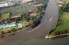
The area south of the confluence of the Main with the Rhine is called the Mainspitze . There are the two so-called Mainspitz communities of Ginsheim-Gustavsburg and Bischofsheim , which were districts of today's Rhineland-Palatinate state capital Mainz from 1930 to 1946 and now belong to the Hessian district of Groß-Gerau .
North of the Mainspitze, separated by the Main, is the Maaraue peninsula with Mainz-Kostheim (one of the so-called AKK suburbs of the Hessian state capital Wiesbaden ) and Hochheim am Main , west of the Rhine the edge of the Mainz old town and the district of Weisenau .
King of Sweden Gustav Adolf had a fortress built on the Mainspitze in 1632 during the Thirty Years' War . In 1673, the Elector of Mainz, Johann Philipp von Schönborn, had the complex razed; today the place name Gustavsburg recalls the fortress. As part of the establishment of the Rhine-Main regional park, signs with the floor plans of the castle were set up in the area of the former Gustavsburg, which, together with the stone cages ( gabions ), give an idea of the outlines of the former castle.
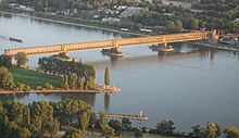
The connection between the A 60 and the A 671 between Bischofsheim, Ginsheim and Gustavsburg is called the Mainspitz triangle . From here bridges lead over the two major rivers.
Many local associations and cultural institutions have the Mainspitze in their name. A daily newspaper in Rüsselsheim is called Main-Spitze . In the route of industrial culture Rhein-Main , the section from Bischofsheim and Ginsheim-Gustavsburg is combined as the Mainspitze route .
Web links
Coordinates: 49 ° 59 ′ 36 " N , 8 ° 17 ′ 43" E

