
Ebertplatz


The Ebertplatz in Cologne Neustadt-Nord combines the largest space of the inner-city ring roads Hansaring with the last of the ten ring sections, the Theodor-Heuss-Ring.
history
Founding period


According to Arnold Mercator's Cologne city view from 1570 , the entire area around Neusser Strasse , including its eastern part, was arable and pasture up to the level of the Kunibert Tower. The structurally undeveloped area between Ebertplatz and the Rhine was outside the medieval city wall and was not allowed to be built on for a long time. An ink drawing by Joseph Michael Laporterie from 1795 also shows the area used for agriculture. As early as 1786 there were plans to build a security harbor at the current location between Ebertplatz and Bastei . But the facility was only decided on during the French period on November 24, 1810 for 750,000 francs; on April 2, 1811, construction of a 500-meter-long and 50-meter-wide winter and security harbor ("Napoleonhafen" or "Thürmchenshafen") began at this point. ) against ice and flooding, for which the first stone was laid in the mouth of the Rhine on November 10, 1812; it opened its doors in the winter of 1813. The harbor basin was 1,600 feet long and 150 to 180 feet wide. However, due to bad planning, city architect Johann Peter Weyer temporarily closed the building in 1829. After 1840 the port increasingly silted up and remains as an unused water surface; as recently as 1888, it was marked in a Greven city map as the “port”. Finally it was filled in in 1890.

Only when the purchase contract between the city of Cologne and the Prussian war ministry (military treasury) became legally effective on May 5, 1881, through confirmation by Reich Chancellor Otto von Bismarck , the city of Cologne was able to purchase the area around the - as yet non-existent - Ebertplatz for 11.74 million marks acquire. She had this inner ring of fortifications torn off, so that the 104 hectare open space could be laid out as a splendid boulevard based on the Parisian Grands Boulevards and the Vienna Ringstrasse . City architect Josef Stübben planned a semicircular ring boulevard on the open space of the former city wall, which was to lead from today's Ubierring in the south to the Rhine in the north. Only a few of the gate castles were spared from being laid down ("de-fortified"), including the Eigelstein gate castle . From here the Neusser Strasse led north, which, according to Stübben's plans, was to cross the new Ringstrasse. Sudermannstrasse, named on December 23, 1886, also ended here; In 1906 it was renamed Sudermanstrasse to avoid confusion with the poet of the same name. Therefore, the city planners did not envisage a simple intersection , as several streets converged here, but a spacious square. Today's Ebertplatz emerged as the southern section of a broad avenue equipped with parks , which was established in the city council meeting in September 1885 with the alignment plan 30 (city planning chamber , new number 183).
This was named Deutscher Platz on January 27, 1887 as the central location of the Deutscher Ring, which was named on the same day . The Ringstrasse "begins with the Ubierring and ends with the newly created German Empire." Stübben planned the creation of a park with a fountain basin in the western part and a pond. As part of the laying out of the Cologne Rings from 1888, Adolf Kowallek created a spacious garden from the Rhine to Deutsches Platz, which was adorned between Neusser Strasse and Riehler Strasse around 1891 by a large pond with three fountains on an area of 6.2 hectares. The city council meetings of March 20, 1890, May 9, 1895 and February 13, 1896 then laid down the route plan from Ebertplatz to today's Konrad-Adenauer-Ufer. Fritz Encke added to this complex from 1918. This northern section of the Cologne ring was only built on with residential and commercial buildings after 1888; the last house at today's corner of Ebertplatz 1 and Sudermanstraße was not finished until 1900. Many of the representative Art Nouveau houses standing here had domed corner towers. On October 1, 1903, a monument created by Peter Breuer for Emperor Friedrich III was unveiled . on the Deutsches Ring at “Kaiser-Friedrich-Ufer” (today Konrad-Adenauer-Ufer).
Terrain, planning and implementation
The place was built in the late 19th century, designed by the architect and town planner Joseph Stübben and Karl Henrici , from that of the City of Cologne advertised emerged competition for urban expansion as a winner.
After lengthy negotiations, combined with the removal of bureaucratic obstacles and the preparation of the development plans, work on the development of the new town could begin. The planned new town belt , the old fortress paleon , was divided into three sections. For the northern section of relevance here, which lay between Gereonstor and the banks of the Rhine at the tower , the terrain was released in June 1885. Objections from the management of the Rheinische Eisenbahn-Gesellschaft , whose route crossed the area in the north of the city, led to repeated delays. The work on the projected Deutsches Ring was restricted due to the not yet granted building permit for the new Rheinauhafen , so that the security harbor , which extends parallel to the Türmchenswall and was finally completed in 1824, could only be filled in after a binding resolution was passed on this matter.
Development and expansion of the infrastructure
Traffic routes, naming and changes
For the Hansaring , which flows into the Deutsche Ring , a width of 40.50 meters was decided. To relieve the expected heavy traffic, it was given Maybachstrasse (established in 1884 and named 1890, built in 1897/99) along the new Gereon freight yard as a parallel street. The street was named after Albert von Maybach . For the Hansaring, Stübben had proposed three rows of trees that were to serve as a rider and pedestrian avenue. At the end of the Hansaring, Sudermannstraße was the first of the following streets to join the Deutsches Ring. It was established as Alleestraße in September 1885 and named in December 1886 after Heinrich Sudermann , a syndic of the Cologne Hanseatic era . The names of adjacent streets, such as Lübecker and Bremer Straße, Hansaring and Hansaplatz , were also associated with the Hanseatic League .
Today's Ebertplatz - at that time still without its own name - formed the beginning of the Deutsches Ring , today's Theodor-Heuss-Ring. The radial streets Neusser Straße and Riehler Straße leading from it into the suburbs were determined in their direction by the position of the gates of the advanced fortress belt, here the Neusser Tor and Riehler Tor. The Neuss Street , as a continuation of the Old City street Eigelstein was in the now discontinued "old Rayon" and had to be developed and built. The Alleestraße was named in May 1883 and was last established in June 1888; Development began between 1890 and 1895. Riehler Straße (formerly the Mülheimer Weg arterial road) was renamed by the city council on May 10, 1883 and was intended as a connecting road leading to the Cologne Zoo, founded in 1860 , as a splendid, 30-meter-wide avenue . It was essentially built on at its beginning and only sporadically in its northern area between 1890 and 1906, with individual buildings still following until 1925.
The Eigelsteintorburg was included in the design of the square via the connecting axis of the “Eigelstein” street towards the old town. The old street name Eigelstein was retained towards the city center. This was decided by the city council in September 1885 with the route plan number 30. As early as May 1882, it was decided to keep the old streets of the old town. The new part of the city became a short avenue street and from 1890 on it was built on.
The retention of their name should therefore also have applied to Theresienstrasse, which then opens into the Deutsche Ring. However, it was renamed after a municipal resolution in March 1893 after a connection with Domstrasse had been established. In the new town area, the development took place around 1894/95.
In the period that followed, the square changed its name several times, depending on the political situation; from July 18, 1922 it was called the Republic Square . The time of National Socialism brought the court immediately after the takeover of the Nazi Party in January 1933 renamed Adolf Hitler -Platz . This was due to a resolution of the city council on March 30, 1933, which made a total of 7 renaming under agenda item 3. After the Second World War it was renamed Deutscher Platz just as quickly in April 1945 . In March 1950, the square was given its current name, Ebertplatz, after the first Reich President Friedrich Ebert .
Railway connections

With the progress of industrialization , the emerging railway lines also served as a new form of trade routes that brought people and goods quickly to their destination. The market of the highly populated region and Cologne joined by 1853 such a distance with the city of Krefeld , whose businesses had specialized and dominated the market in the production of fine textiles. The line of the Cöln-Crefelder Eisenbahn-Gesellschaft , which initially ran between these cities, had its terminus in the north of the city, on the banks of the Rhine there shortly before the future German Ring and was initially called Am Thürmchen. After the company was taken over by the Rheinische Eisenbahn-Gesellschaft in 1860, the new station a few meters away was given the name Rheinstation.
A planned , so-called fan station, which the Prussian government had planned as a collection point for military equipment in the event of mobilization , was to be connected to the track network of the Rhenish Railway. However, since a simultaneous connection to the northern port of the city (old security port) was omitted due to the decision to build the new Rheinau port, the compartmentalized railway station, which had impaired the construction planning for years, was not realized. It would have covered roughly the area of today's Higher Regional Court on Riehler Strasse. There the Weißenburgstrasse, which was then implemented as an avenue and railway road, would have connected the military station with the freight yard and the Rhine station.
Horse and trams

The expansion of a network of horse-drawn trams began in 1877, without involving the city administration, with a contract between the Prussian government and private operators. These had been granted concessions that allowed them to set up a line service by horse-drawn trams on non-urban roads , which changed accordingly with the later electrification . The concession was awarded to the Belgian entrepreneur Fredéric de la Hault, who later went up with the concessionaire Hardt, the operator of the first suburban railways on the right bank of the Rhine in the “Cölnische Straßenbahn-Gesellschaft”.
A contract dated July 19, 1882 between the city of Cologne and the operator Ernst Hardt & Co. provided for, among other things, a horse-drawn railway line ("Pädsbahn") from Cologne-Mauenheim via Neusser Strasse and Eigelstein to Allerheiligenstrasse. The rails led directly over the German Ring. Another horse-drawn tram ran from April 10, 1889 from Ubierring to Ebertplatz, where it crossed the Eigelstein-Nippes-Bahn and continued on Riehler Strasse to Cologne Zoo and Flora . A circular track around the large Brunnenteich at Deutscher Platz therefore took care of the traffic. The third horse-drawn tram took the route to the old town from Thürmchen (Clever Strasse) - Trankgasse and Frankenplatz.
In April 1900 the city took over the Ernst Hardt & Co. company for a price of 20 million marks and ran it under its own management. With the construction of the city's gas, electricity and waterworks in 1891 - the first "Central Station" in Neustadt-Süd - the arrival of electricity began and gradually became available for the entire city. It was also she who gave birth to the tram known in Cologne as the “electric” and replaced the horse-drawn trams. From October 15, 1901, the electric railway replaced this horse-drawn tram and served as a ring railway on the route from the Deutsches Ring to the Ubierring. Under the leadership of the municipal councilor Peter Scheidtweiler the old horse tram-lines were retooled and expanded its route network.
From May 18, 1930, the suburban railway line D drove over the round trip track at Ebertplatz as the end point of the second suburban railway line leading over the Mülheim bridge to Thielenbruch and Bergisch Gladbach .
Electricity and water supply
The Alteburg waterworks had supplied the city center with drinking water since 1872. However, its capacity for the expected increase in population due to the development of the new town was not considered sufficient. New facilities were necessary, which the city had to plan and build on a site acquired for 60,000 marks. The building site was located on a dirt road called a Zugweg in the southern fortification area , which had previously been checked for water productivity, and had received a special permit for building from the military authorities.
The Severin I waterworks at Zugweg 7 was built, which was completed in 1885 and expanded to include the Severin II pumping station in 1901 , as well as an underground drinking water reservoir. In 1891 the city began to supply electricity, which gradually reached all parts of the city.
The municipal utilities growing into a group, in whose development the already mentioned alderman Scheidtweiler played a key role as co-founder, supplied not only private households but also commercial enterprises and municipal facilities, such as the new trams that ran between the Ubier and Deutscher Ring.
Sewer systems
The municipal building officer Carlsteueragel had been responsible for a new urban sewer system under Stübben since the beginning of 1881 . Up to this point in time there were only 16 km of canals, the contents of which collected incoherently in city ditches or puddles in order to seep away there.
The canal construction then proceeded according to plan under him was extensive. The builder saw himself as an engineer and an archaeologist , who also dealt with the exploration of the ancient city. In his new task, he also orientated himself on the technology used by the Romans of the still existing drainage channels of the ancient CCAA in order to develop a new system for Cologne city drainage. The system developed at that time by Steueragel has proven its worth and its basic features are still in place today. The now listed vaults of the rain overflow structure , the so-called chandelier hall under today's Theodor-Heuss-Ring, as well as small technical monuments or the remainder of a railway viaduct at the former freight station in Nordstadt are evidence of the engineering skills of the 19th century.
Garden architecture of the ring sections


While the first of the ten ring sections were designed under the direction of the Cologne gardening director Anton Strauss , from 1888 the gardening architect Adolf Kowallek was responsible for the completion of the gardening design. Under him, the Ringstrasse with its various plazas could essentially be completed by 1901.
For the design of the Deutscher Ring section, Kowallek was able to fall back on the Eigelstein Glacis that was created in 1826 based on the designs of the former garden architect Maximilian Friedrich Weyhe . This was about three hectares of land that had been excavated from the earthworks of the security harbor and formed into a lofty park . This existing glacis, with a width of 130 m and a length of 90 m, became the base of the German Ring.
Responsibilities
According to an order of Mayor Wilhelm von Becker from July 1904, various responsibilities were determined for the public facilities and their facilities, as well as their maintenance. As a result of this arrangement, the gardening authorities under the direction of Fritz Encke were subject to the following areas of responsibility, which are only listed here in a selection. Although these arrangements related to the entirety of the municipal facilities, they give an example of the tasks to be mastered by the departments concerned with regard to the rings, of which the German Ring dominated in the area of its facilities.
- "All gardens with their paths, children's playgrounds, tree plantings and their protective cages and poles, procurement and maintenance of benches, fences, grids for the railway lines, supervision and operation of the lighting systems of the facilities (with the assistance of the management of the gas, electricity and waterworks) , as well as the maintenance of the drinking fountains and fountains and ponds, the water pipe and sprinkler system of the promenades and bridle paths, as well as the supervision of the restaurants in public facilities and those in the squares (the city had planned the construction of a urinal for each section of the ring) established lavatories ".
Horticultural design of the Deutsches Ring
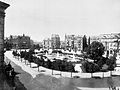
The gardens on the Deutsches Ring are described in detail in an edition of the Kölner Stadtanzeiger from September 7, 1907. So beautifully developed lawns, ornamental shrubs and thorns with acacias planted in between were listed. The trees on the equestrian statue of Emperor Friedrich , which has now grown for a few years, have grown to a good height, and coming from Kaiser-Friedrich-Ufer you walk along beautifully paved paths, which are lined on both sides by ornamental shrubs and conifers. The tree planting of the park consisted mainly of oaks on the inner and outer paths. Then you reach a deeper pond, which is surrounded by sturdy willow trees, again acacias and other wood. Leaving this body of water behind, you reach a large water basin surrounded by flowering plants, the center of which is equipped with several fountains .
A few years later, the Deutsche Ring was enriched by another attraction. He received a children's playground built by Bolte around 1911/12 . The area of the complex framed by bars between brick posts - the emperor's monument stands on a high, rounded base in photographs - was flanked by sculptures in the entrance area on both sides. The figure groups “Young man with horse” and “girl with deer” placed on plinths were originally created by Hans Wildermann in 1911 for the Sonderbund exhibition in 1912 and were now located here until the Second World War.
City districts and buildings from the Wilhelminian era

Hansaring - towards Ebertplatz (around 1886)
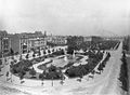
Ebertplatz - to the east, left Riehler Straße (July 1899)
Ebertplatz - to the northwest, Sudermanstraße (July 1899)

Ebertplatz - today's Theodor-Heuss-Ring / corner of Greesbergstraße (around 1900)

Ebertplatz - corner of Riehler Straße 3 (around 1900)

Ebertplatz - equestrian statue of Friedrich III (October 1903)


The development of the new town in 1881 was followed by development in 1882. The development of the Deutsches Ring (the area of the later separated square) started relatively late and took place between the years 1888 to 1895, only house number 15 between Neusser and Riehler Straße was only built in 1900. Number 1, at the corner of Hansaring and Sudermannstrasse, was built by the architect Otto Schulze on behalf of Magdeburger Allgemeine Versicherungsgesellschaft as a rental building with a "sophisticated" design.

City architect Stübben's plans had foreseen a general maximum height of 20 m for the development of the ring roads, a project which he could not enforce in practice against the other members of the city expansion deputation. The old building regulations were often adhered to, which, among other things, stipulated a storey height at which a clearance height of 3 m was not to be fallen short of.
As photographs from the turn of the century make clear, the complex, which was later designated as a square, was mostly surrounded by four-story buildings. Their upper floors were usually built at the same height, in contrast to the ground floors, which were often used as business premises, were given a higher dimension. The house facades were given not only decorative elements, such as those on the imperial pharmacy, but also a coordinated structure in the street alignment through elaborate stucco work. Typical of the buildings of this era were the high windows and house entrances, but also the house fronts, some of which had bay windows. Most of the buildings had extended mansards, with corner structures also being given smaller or larger towers.
Villas and their architects
The planning envisaged a four-storey construction of terraced houses as well as the creation of front gardens for the southern side (from about the later Domstrasse) of the broad avenue of the German Ring. On the other hand, an open development was decided for the north side (from Riehler Strasse), as this should merge into the planned villa district between Riehler Strasse and the banks of the Rhine.
Villas of well-known Cologne citizens of the upper social class were built on the avenue, which was mainly built between the years 1895 and 1900. (Old numbering appears in brackets, no details are available about skipped house numbers.)
- City-side, closed development
- 1894/95, No. 10 (26) executed by the Cologne building contractor Heinrich Schierenberg (facade design: Alfred Müller & Otto Grah)
- 1900, No. 26 (42) Architects: Gebrüder Schauppmeyer
- 1903, No. 28–30 (44/46) Rottländer semi-detached house
- 1897/98, No. 34 (54) on the corner of Clever Strasse (Kaiserapotheke)
- 1900, No. 50 (72) Gerlach House

Villa Bestgen in Art Nouveau style, Theodor-Heuss-Ring 9

Theodor-Heuss-Ring 10

Theodor-Heuss-Ring 20

Decoration of the facade of the imperial pharmacy built in 1899 on the Deutsches Ring


- Villa location on the outer ring side
- 1895/96, No. 3 and 5 (25-27) as a double villa Wirtz-Schnorrenberg
- 1897/98, No. 7 (29) Villa Welter
- 1903/04, No. 9 (31) Villa Bestgen (architect Gottfried Wehling )
- 1903/04, No. 11 (45) Villa C. Th. Von Guilleaume (architect Ernst Eberhard von Ihne )
- 1895/96, No. 13–15 (47/49) as a double villa Richard and Paul Schnitzler (architect Hermann Otto Pflaume )
- 1912/13, No. 19–21 (53/55) as a double villa Johann Heinrich von Stein and Max Heimann (architect Paul Schultze-Naumburg )

War destruction
With a degree of destruction of 78% determined for the city as a whole, the Neustadtgürtel got off relatively well with around 25% destroyed building fabric. This balance , however, was again an average value that disregarded the true, punctually very differently occurring damage. A list of the parish of St. Agnes in July 1945 indicated 16 completely destroyed and two heavily damaged houses for the Deutsches Ring.
Because of the emerging incorporations, consideration had already been given in the context of the Neustadt planning to connect the ring roads at their ends with bridges with the area on the right bank of the Rhine. However, the city postponed this project and later favored other bridge locations. With the destruction of the Cologne bridges, the Deutsche Ring became a bridge approach, if only for a few years. In 1945/46 a so-called Bailey Bridge was installed, which in Cologne was named "Patton" Bridge after the General of the US Army George S. Patton . For the construction of the bridge access the war-damaged monument of Kaiser Friedrich and the equally damaged groups of figures by Wildemann at the playground of the ring were removed. The bridge was one of three emergency bridges built during the occupation of Cologne. It was built in the period from October 1, 1945 to June 12, 1946 and demolished in September 1951.
The beginning of the reconstruction
The first plans of the post-war period also envisaged a standardization of the ring width and a change in the current heights for the development. Indeed, because of the expensive land compensation that had then become due, the widening to 52 meters was refrained from, but the height development was now set at six to seven floors. These decisions of the city - also made in favor of the landowners - changed the ring architecture prescribed by Stübben to a considerable extent, which also manifested itself in this style on the northern section of the rings, now known as Deutscher Platz. The responsible urban builder was the architect Rudolf Schwarz , who organized the reconstruction from 1946 to 1952.
Traffic development

As early as July 1953, the number of vehicles registered in Cologne exceeded the 50,000 mark. This led to bottlenecks, especially at critical traffic points, including Ebertplatz. The traffic on the square was mainly determined by the north-south connection of the ring and the Neusser Strasse - Eigelstein axis, as well as the incoming and outgoing traffic on Riehler Strasse and Sudermannstrasse. The ground level operation of the double-lane tram lines, which even squeezed through the Eigelsteintor, had a particular impact on the square. A traffic policeman standing on a small pedestal controlled all traffic at the intersection with a show of hands, until a few years later the previous form of traffic control was replaced by a traffic clock above the intersection .
Loss of substance

At the end of her publication on Cologne Neustadt in 1978, the later Cologne city conservator Hiltrud Kier stated that even after the destruction of the war, the Neustadt lost about 25% of its structural substance in the following three decades. She saw the reason for this decline in the growing volume of traffic, to which the authorities reacted with widened and new roads and to which land and buildings worth preserving were sacrificed. Furthermore, changed development plans ensured that, due to the higher land utilization that was now possible and thus higher returns, the buildings that were still in existence were more or less "doomed to demolition".
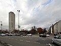
In contrast to the southern ring section of the Sachsenring (between this and the Volksgarten ), which Stübben and the north side of the Deutsches Ring had planned with predetermined villa development , the area on Theodor-Heuss-Ring between Riehler and Rheinuferstraße was released for high-rise buildings in 1970 . As a result, a number of tall buildings were built in this triangle, the most striking of which was the Ringturm, built in 1973 on Theodor-Heuss-Ring 1.
Theodor Heuss Ring
After the death of Theodor Heuss on December 12, 1963, the city council unanimously decided in a council meeting on December 14, 1963 to rename the German ring leading from Ebertplatz to the Rhine into Theodor-Heuss-Ring. Construction began here around the turn of the century, for example in 1897 (No. 32), 1898 (No. 34) or in 1903 by Rottländer, the semi-detached house No. 28-30 and in 1912 a children's playground. The excavation of the security harbor here enabled the creation of a park with a pond. In 1970 the old security harbor was uncovered during excavations at Theodor-Heuss-Ring. The 109.1 meter high ring tower (Theodor-Heuss-Ring 1), visible from afar, was completed in 1973.
Preservation assessment in the 1970s

In her capacity as a monument conservator, Kier looked at the past construction times of the city and reported on walls that had been towering for years and the facades of burned-out houses that were worth preserving, but which were ultimately demolished or used with chipped stucco in an unadorned reconstruction. In the list of monuments in the Neustadt-Nord district, only three buildings are listed as monuments for today's Ebertplatz, and twelve buildings are listed on the former Deutsches Ring. Among these, however, a number of buildings from the immediate post-war period are already included, remains of the facade from the Wilhelminian era or what has been preserved in Art Nouveau are the exception.
The formerly lush greenery of the city, particularly that of the ring and its squares, remained decimated for the time being. This is illustrated by photographs of the Wilhelmine era (see illustration above, Deutscher Ring), but also by August Sander , whose view from the Platz der Republik in the Hansaring shows a wide boulevard with three rows of trees in the middle .
1970s remodeling
Road construction

According to the former city curator Ulrich Krings, plans by the NS city administration took place as early as the 1930s, dealing with the alignment of an east-west and a north-south axis in order to quickly cross the city by means of broad streets can. As part of long-term planning, land had already been acquired in 1936, but the project was not implemented due to the outbreak of war.
It was possible to fall back on these early considerations and elaborations, which saw a massive increase in automobile traffic coming through the city center, in the post-war period. As a suitable measure to steer the traffic volume that has now occurred by creating suitable road profiles, the city administration decided to build the north-south route in stages . As such, this touches Ebertplatz with the connection between Turiner and Riehler Straße and was essentially completed in December 1972 with the exception of the connection to the Zoobrücke . With the construction of this six-lane road (without turning lanes), the Greesbergstraße, which formerly opened onto the Ring (built in 1895/96) lost its substance in 1970 and the Ringstraße lost property number 2. On April 27, 1975, the last section of the north became -South drive connected to the Zoobrücke via Riehler Straße.
Modification of the plaza by building the underground station
The construction of underground routes, station systems and their entrances and exits, which has been continuously advanced from the city center since the mid-1960s, also included Ebertplatz.

Since the opening of the Ebertplatz underground station on August 25, 1974, the lines coming from the Breslauer Platz underground station and the ring train coming from the Hansaring underground station have met here , creating the first Cologne underground station with four parallel platforms. With the tram lines 12, 15, 16 and 18 it is also the largest underground junction of the Cologne tram. From 1972 the above-ground renovation work on Ebertplatz began, the western part of which was lowered below street level and accessed via stairs, escalators and ramps. The seven shops in the basement and the water kinetic sculpture by Wolfgang Göddertz were intended to activate the new space. When it was set up in 1977, the square was considered completed. The remaining green area in the eastern part of Ebertplatz takes up 3.2 hectares.
As a junction of various traffic flows and traffic distributors, which distribute the various road users on separate levels, the pedestrian level was classified into the lowered zone, as is typical of the time, while the car traffic was at ground level.
Separation of the square and "Ringpark" by the north-south drive

The pedestrian traffic between Eigelstein and Neusser Straße was guided underground with escalators.

The "zero level" is reserved for car traffic.


Today's Ebertplatz
Ground level details

Today's square has been surrounded by seven to eight-story buildings on its flanks since the post-war height restrictions were lifted, which have a few remnants of the Wilhelminian era. During the rebuilding from 1945 onwards, the original alignment plans were based , so that the dimensions of the area were retained. The first building after the war was the administration building for AachenMünchener Versicherung in No. 14–16 (corner of Riehler Strasse) after 1945 . The Stadtsparkasse Köln (No. 1) had its main branch, Ebertplatz, built in 1950 by the architect Theodor Kelter . One of the early buildings is the Bayer House (architect: Ernst Nolte ) in No. 2 , which was built in 1957. The interior of the listed house has a well-preserved spiral staircase with a wrought-iron flight of stairs . House number 8, which was designed by architect Paul Michael Pielen in 1960 , is also a listed building. Between 1957 and 1973 the Bambi am Ring cinema was located in No. 11 . The building with the arthouse cinema Metropolis was built in No. 19 in 1950 and opened here as the Burgtheater on April 21, 1950 . The development is a mixture of residential and commercial buildings, including three financial institutions. Haus Bayer became a medical center , a successor to the long-established Café Füllenbach (No. 14-16) filed for bankruptcy in 2002. Two-lane lanes run in front of the sidewalks of the rows of houses on both sides, with an additional bus lane with a stopping point being set up on the side out of town. Another bus station is located at the head of the square on the north-south drive crossing there.

Corner houses on Sudermannstrasse
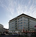
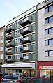
Ebertplatz 2
Ebertplatz 8

Bus station at the end of the square (north-south journey)


Inner square level
The square developed both at ground level and underground to become the most important traffic junction in the northern Neustadt. In terms of design, the square is based on polygonal elements, all of which are derived from the dominant hexagonal shape of the atrium above the row of shops and the supporting pillars.
The typical design of the square (planner: Kurt Jatho ) is largely unchanged. The evaluations of the quality of stay differ: Criticisms are the interrupted connection between Eigelstein and Agnesviertel, the square surrounded by car traffic around the lowered square, which is assessed as no longer contemporary and dysfunctional, empty shops and an unclear transition from the Ringstrasse to the banks of the Rhine. Some voices go so far as to certify that the design has “far-reaching planning errors”.
Other authors certify that the square is a "shelter for pedestrians with a good quality of stay" due to the now mature bush and tree population. The well system would also have taken on noise protection tasks as it dampened the emissions from car traffic. However, the well was out of order from the late 1990s until the summer of 2018.
From the lower level, which could be reached by escalators and an elevator (the escalators are now out of order), the most striking buildings in the area, the Eigelsteintorburg and the Agneskirche, are only partially visible from the lowest side of the square with the Eigelstein / Neusserstraße visual axis . At times the place was not very busy; the roofed shops, some of which have been vacant, have been used by Cologne artists for a number of years, and they also house an African restaurant and a copy shop. The program of these off-spaces is known to an art-interested public far beyond the city limits.
Opposite the fountain there is a wheelchair-accessible , gently sloping paved path to the upper center of the square, with its bus terminal served by several lines , which offers its passengers the option of changing to the lines of the light rail. For this purpose, there are further entrances and exits to the upper street level (Riehler Strasse / Ring and Ebertplatz / Turiner Strasse) at the northern end on both sides of the square, as well as in the underground basement with public (not wheelchair-accessible) toilets and the corridors to the stairs and escalators of the respective head sides of the subway station.

As part of the exhibition Mofahügel with Evamaria Schaller, Sören Siebel and Julia Wallstab on the inner Ebertplatz area as well as in the boutique - space for temporary art , one of the four off-spaces in the basement, the artist Max Erbacher installed three urinals on a exposed aggregate concrete wall , which are often used at night is used by men to urinate. After one of the urinals was destroyed in January 2012, the city council also removed the remaining two.

Vacancy and open pipelines

Toilet facilities

Refuge for the homeless

Stairs to the subway


Neglect, criminal focus
As a result of inadequate maintenance and care on the part of the city, defective escalators and the draining of the well, the square showed a picture of neglect for years and was avoided by the public, so that the public space here was occupied by other clientele. In 2017 in particular, it repeatedly hit the headlines as the scene of drug deals and violent crimes. After increased presence, the Cologne police reported an increase in reports of violations of the Narcotics Act compared to 2016. The lack of clarity of the square with its underground and above-ground entrances including the subway, poorly illuminated corners and corridors and numerous opportunities for drug hiding resulted to the fact that drug dealers of various nationalities were active there without being able to be monitored by the police to improve this situation.
The Kölner Stadt-Anzeiger reported on a conflict between North and West African groups at Ebertplatz, which not only culminated in violence between the groups several times in 2017, but also led to the death of a 22-year-old man from Guinea in October of that year following a knife attack . Passers-by and residents would now largely avoid the square. Until a planned redesign of the square according to Albert Speer's urban development master plan , police controls, video surveillance, increased cleaning of the square, improved lighting and the removal of flower pots that serve as drug hiding places should ease the situation. The idea of closing some entrances to the square completely was rejected again. Another person was killed in a mass brawl in August 2019.
Civic engagement, temporary use and discussion about monument protection


In the course of increasing appreciation of architectural post-war modernism and after the Ebertplatz got more into the headlines due to the events mentioned, various initiatives have been manifested since 2017/2018 to maintain and revive the square in its existing form. Civil society groups under the label “Our Ebertplatz” presented concepts for temporary use in cooperation with the city's cultural office and urban space management, such as gastronomy, additional greenery or socio-cultural offers. The city of Cologne provided 1.2 million euros in investment and program budget for the interim . An emotional and audience-effective component in this process was the initiative of Stefanie Klingemann and Grischa Göddertz, the son of the artist Wolfgang Göddertz , to renovate and reactivate the central fountain after around 20 years of drought. On July 14, 2018, the water kinetic plastic was ceremoniously put back into operation with a large public participation. At the same time, students at RWTH Aachen University erected a wooden platform with movable seat backs on a bed encased in concrete. A container café for outdoor catering was also installed.
Shortly beforehand, the Rhenish Association for the Preservation of Monuments and Landscape Protection and the former cathedral master builder Barbara Schock-Werner had campaigned to put Ebertplatz under monument protection. It is "an excellent example of brutalist urban space architecture, which is to be regarded as unique in its spatial dimensions, at least for Cologne". The Landschaftsverband Rheinland (LVR) with its monument authority wanted to examine a protection status - but shortly afterwards put the decision back in the hands of the monument conservator of the city of Cologne as the lower monument authority. Its head, Thomas Werner , refused to be placed under protection.
Future appearance
The redesign of Ebertplatz, which was initially treated as a single point, was included in the overall planning concept of the Ringstrasse ("Rings Intervention Room") as part of the Cologne city center master plan . The upgrading of Ebertplatz is one of the priority projects within the master plan approved by the city council on May 5, 2009. "Ebertplatz has significant urban development deficits and is in a poor structural condition", it should be examined "for the possibility of regaining quality of stay and clear design language". Originally by 2018, the entire square was to be designed at ground level with direct paths, meanwhile (2018) 2020 is named as the date. The city's announcement also referred to the fact that "social control" was only possible to a limited extent due to the existing height differences and the tunnel structures beginning at the edges of the square. For a while, the political discussion about the redesign revolved primarily around the size and thus profitability of the underground car park that was to be built below the square, an idea that has since been discarded.
A council decision of 2018 called for the elements of the temporary use, which had been agreed until 2021, to be included in the further planning process for the redesign.
literature
- Hiltrud Kier : The Cologne Neustadt: planning, development, use. Schwann, Düsseldorf 1978 - ( contributions to architectural and art monuments in the Rhineland ; Volume 23), ISBN 3-590-29023-4 .
- Henriette Meynen. In: Werner Adams and Joachim Bauer (eds.): From the botanical garden to urban green - 200 years of Cologne green. (Stadtspuren - Monuments in Cologne, Volume 30), Bachem Verlag, Cologne 2001, ISBN 3-7616-1460-8
- History workshop “Agnes - Viertel”, community center Alte Feuerwache, Melchiorstraße Cologne. Brochures on the history of the district. Born in 1987, 1988, 1989 and 1991.
- Carl Dietmar: The Chronicle of Cologne. Chronik Verlag, Dortmund 1991, ISBN 3-611-00193-7 .
- Marcus Trier : Archeology in Cologne Canals - In the footsteps of Rudolf Schultze and Carl Steuerungagel. In: HG Horn, H. Hellenkemper, G. Isenberg, J. Kunow (eds.): From the beginning - Archeology in North Rhine-Westphalia. Writings on the preservation of monuments in North Rhine-Westphalia 8 (Mainz 2005)
- Ulrich S. Soenius, Jürgen Wilhelm (Ed.): Kölner Personen-Lexikon . Greven, Cologne 2007, ISBN 978-3-7743-0400-0 .
Individual evidence
- ↑ Peter Fuchs (ed.): Chronicle of the history of the city of Cologne. Volume 2, 1991, p. 117
- ^ Karl Georg Jacob, Matthias Joseph de Noël , Johann Jacob Nöggerath : Cologne and Bonn with their surroundings: For foreigners and locals. Edited from the best and especially from unused sources. 1928; quoted and commented in: Uwe Westfehling: The first Cologne city guide from 1828. JP Bachem Verlag, Cologne 1982, p. 160 ff.
- ↑ Walther Zimmermann: The art monuments of the Rhineland. Volume 23, 1978, p. 33
- ↑ Hans-Joachim Völse: Cologne , 2008, p. 18
- ↑ Iris Brenner: Cologne Monuments 1871-1918. 2003, p. 312
- ↑ From the Gereon freight station - today's Mediapark site - the railway line ran south along the outer edge of the new wall
- ^ Hiltrud Kier: The Cologne Neustadt: planning, development, use. Schwann, Düsseldorf 1978, p. 32 f. and 88
- ^ Hiltrud Kier: The Cologne Neustadt: planning, development, use. Schwann, Düsseldorf 1978, section: The urban planning implementation, p. 66
- ↑ Alignment plan 33a No. 183
- ↑ Werner Jung: The modern Cologne: 1794-1914; from the French period to the First World War. Bachem, Cologne 2004, ISBN 3-7616-1590-6 , p. 270
- ^ Hiltrud Klier: The Kölner Neustadt: planning, development, use. Schwann, Düsseldorf 1978, section: Alphabetical index of streets, squares and parks, p. 123 ff.
- ^ Marion Werner: From Adolf-Hitler-Platz to Ebertplatz. 2008, p. 17
- ^ Hiltrud Kier: The Cologne Neustadt: planning, development, use. Schwann, Düsseldorf 1978, p. 134
- ^ Hiltrud Kier: The Cologne Neustadt: planning, development, use. Schwann, Düsseldorf 1978, p. 88 and map volume. General plan for Cologne city expansion by city architect J. Stübben in 1883 and map 25 from 1888
- ^ Carl Dietmar: The Chronicle of Cologne. Chronik Verlag, Dortmund 1991, p. 700
- ↑ The development of the Agnesviertel. In: History workshop “Agnes - Viertel” brochures from 1987, p. 6 f.
- ^ Carl Dietmar: The Chronicle of Cologne. Chronik Verlag, Dortmund 1991, p. 263 and 300
- ^ Hiltrud Kier: The Cologne Neustadt: planning, development, use. Schwann, Düsseldorf 1978, p. 71, note 159
- ↑ GEW Cologne
- ↑ Ulrich S. Soénius, Jürgen Wilhelm: Cologne individuals dictionary. 2007, p. 469
- ↑ Markus Trier: Archeology in Cologne canals - In the footsteps of Rudolf Schultze and Carl Steuerungagel. 2005, pp. 160-167
- ↑ a b Henriette Meynen, in: Werner Adams and Joachim Bauer (eds.): From the Botanical Garden to the Big City Green - 200 Years of Cologne Green , Ringanlagen p. 29 and 54 f.
- ↑ Joachim Bauer and Carmen Kohls, in: Werner Adams and Joachim Bauer (eds.): From the Botanical Garden to the Big City Green - 200 Years of Cologne Green , Expansion of Local Government, p. 116
- ^ Probably the municipal building officer Friedrich Bolte [1]
- ^ Hiltrud Kier: The Cologne Neustadt: planning, development, use. Schwann, Düsseldorf 1978, figures 466, 467 and 468
- ^ Museum Ludwig (ed.): Sculpture in Cologne . 20th century images in the cityscape. Cologne 1988. pp. 197-198
- ^ Hiltrud Kier: The Cologne Neustadt: planning, development, use. Schwann, Düsseldorf 1978, pp. 102 ff and 134
- ^ Hiltrud Kier: The Cologne Neustadt: planning, development, use. Schwann, Düsseldorf 1978, p. 103 f, with reference to: Stadtarchiv Köln, Dept. 26/13, Bl. 13-14
- ^ Hiltrud Kier: The Cologne Neustadt: planning, development, use. Schwann, Düsseldorf 1978, p. 176 f
- ^ Hiltrud Kier: The Cologne Neustadt: planning, development, use. Schwann, Düsseldorf 1978, section: The New Town after World War II, p. 209 ff.
- ↑ The wartime 1939 - 1945. In: Geschichtswerkstatt “Agnes-Viertel” brochures from 1989, p. 25
- ^ Hiltrud Kier: The Cologne Neustadt: planning, development, use. Schwann, Düsseldorf 1978, p. 176 f, note 593 and figure 334
- ↑ HASTK The emergency bridges of the post-war period ( Memento of the original from November 7, 2017 in the Internet Archive ) Info: The archive link has been inserted automatically and has not yet been checked. Please check the original and archive link according to the instructions and then remove this notice.
- ^ A b c d Hiltrud Kier: The Cologne Neustadt: planning, development, use. Schwann, Düsseldorf 1978, section Die Neustadt after World War II, p. 209 f.
- ^ Carl Dietmar: The Chronicle of Cologne. Chronik Verlag, Dortmund 1991, p. 450
- ^ Marion Werner: From Adolf-Hitler-Platz to Ebertplatz: A cultural history of Cologne street names since 1933. 2008, p. 42
- ↑ According to Henriette Meynen, there may still be a cedar tree from the Eigelstein Glacis on the property at Theodor-Heuss-Ring 9
- ^ Ulrich Krings in a publication from October 2006
- ^ Carl Dietmar: The Chronicle of Cologne. Chronik Verlag, Dortmund 1991, pp. 450 and 505
- ↑ a b c d Martin Bredenbeck: “Cleaning and using!” In: Kölnarchitektur. July 10, 2018, accessed July 15, 2018 .
- ↑ Kelter also built the main office of the Stadtsparkasse Habsburgerring 2-12; completed in 1953
- ↑ Since May 1, 1986 it has been called Metropolis.
- ↑ The short way from top to flop: Frank Schauhoff. In: Kölner Stadt-Anzeiger. January 24, 2002, accessed July 15, 2018 .
- ↑ Uta Winterhager: Focal Point Ebertplatz. In: Cologne architecture. April 13, 2014, accessed July 15, 2018 .
- ↑ Archive link ( Memento of the original from September 29, 2015 in the Internet Archive ) Info: The archive link was inserted automatically and has not yet been checked. Please check the original and archive link according to the instructions and then remove this notice.
- ^ Ingo Hinz: Crime in Cologne: permanent problem Ebertplatz . In: Kölner Stadt-Anzeiger . ( ksta.de [accessed October 24, 2017]).
- ↑ Tim Stinauer: Commemoration for Youssuf F .: Almost a hundred people mourned at Ebertplatz. In: Kölner Stadt-Anzeiger. Retrieved October 24, 2017 .
- ↑ Cologne's Ebertplatz is becoming a no-go zone - and the police are powerless. In: Focus Online. Retrieved October 24, 2017 .
- ↑ Tim Attenberger: Cologne's Problem-Platz: More light on Ebertplatz should bring more security. In: Kölner Stadt-Anzeiger. Retrieved October 24, 2017 .
- ↑ WDR: Man dies in a mass brawl on Ebertplatz. August 25, 2019. Retrieved August 25, 2019 .
- ↑ Anke von Heyl: Dealing with the building heritage - the discussion about the Ebertplatz. In: brutalisten.de. June 18, 2018, accessed July 15, 2018 .
- ^ "Our Ebertplatz" initiative. Retrieved July 14, 2018 .
- ↑ Uta Winterhager: Now what to do at Ebertplatz. In: Cologne architecture. March 7, 2018, accessed July 14, 2018 .
- ↑ Tim Attenberger: 230,000 euros for the repair of the fountain on Ebertplatz should bubble again. In: Kölner Stadt-Anzeiger. March 6, 2018, accessed July 14, 2018 .
- ↑ Anna Hört: Cologne's Ebertplatz. The “Nagel” fountain bubbles again - refreshment on a hot day. In: Kölner Stadt-Anzeiger. July 14, 2018, accessed July 14, 2018 .
- ↑ report-k.de Editor: On Saturday culture and running water at Ebertplatz. In: report-k.de. Retrieved July 23, 2018 .
- ↑ Tim Attenberger: Redesign in danger Cologne's Ebertplatz should become a monument. In: Kölner Stadt-Anzeiger. May 25, 2018. Retrieved July 14, 2018 .
- ↑ Tim Attenberger: Examination surprisingly stopped Cologne's Ebertplatz will not be a monument. In: Kölner Stadt-Anzeiger. June 1, 2018, accessed July 14, 2018 .
- ↑ Urban development master plan downtown Cologne ( Memento of the original from March 7, 2016 in the Internet Archive ) Info: The archive link was inserted automatically and has not yet been checked. Please check the original and archive link according to the instructions and then remove this notice. (PDF; 829 kB)
- ^ Mathias Hendorf: Redesign. The city does not want an underground car park on Ebertplatz. In: Kölnische Rundschau. June 21, 2017. Retrieved July 15, 2018 .
- ↑ Brutalism Practice. In: Cologne architecture. January 21, 2017. Retrieved July 15, 2018 .
Web links
- Christian Parth: Against fear. In: Zeit Online , November 18, 2017
- Tim Attenberger: Monument protector for Ebertplatz "An imposition especially for women". In: Kölner Stadt-Anzeiger , June 3, 2018
- Website Our Ebertplatz
Coordinates: 50 ° 57 '2 " N , 6 ° 57' 28" E