
Volksgarten (Cologne)


The Volksgartenstraße is in the southern Neustadt Cologne preferred 13.9 hectare large green area with children's playgrounds, a 5.5-hectare pond with Kahn Tretbootverleih , garden restaurant and beer garden . Music events, films and theater performances are also offered in the orangery .
location
The park is located near the Sachsenring between the Volksgartenstraße, which is designed as an avenue with a central green strip, and the foothills of the foothills running parallel to the south, which is only accessible as a footpath and cycle path before the adjacent green embankment to the Cologne South Bridge . On the narrow sides, the park is bordered by Eifelstrasse and Eifelplatz as well as the Vorgebirgstrasse. Via this, through some green zones, you reach the foothills park that begins immediately to the east behind the railway embankment .
history
The park was built from 1887 to 1889 on the site of Fort Paul, built by Prussia from 1816 to 1825, or - numbered - Fort IV, named after the son-in-law of Friedrich Wilhelm III. , the Grand Duke Paul Friedrich of Mecklenburg , which was the first work to be abandoned after the Franco-Prussian War because it was too close to the city and was also restricted in its function by the railway line. The park was thus the first part of the part of the fortress ring of Cologne that was later converted into the Inner Cologne Green Belt .

Entrance Vorgebirgstraße at the corner of Volksgartenstraße

Old trees and pond

Middle section of the foothills
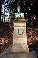
Memorial stone for Commercienrath Wilhelm Kaesen, reconstruction of the bust of Ákos Sziráki 2002


In 1888, the Cologne city architect Josef Stübben , whose urban expansion plans included the Volksgarten, wrote about the creation of the Volksgarten: “This park could not be placed in the location that was originally intended for it, because the land acquisition negotiations with the numerous Owners did not have the desired result.

A city councilor, the late Commercienrath Wilhelm Kaesen, therefore undertook to buy around sixty different private plots of land elsewhere for his own account, which formed a contiguous area of approximately 10 hectares and with two old fortifications owned by the city (Fort IV and Lunen 3) as well as several later acquired parcels for the creation of an urban park were so suitable that the building plots surrounding the park also became the property of the city. In the summer of 1886, Mr. Kaesen offered the city the land at a purchase price of 680,000 marks and also donated a special amount of money for a beautification system for the new park. The city council accepted the offer with a warm thank you. ” The city then announced a competition. The first prize was won by Adolf Kowallek , the second by Eduard Hoppe . In November 1887, the city of Cologne commissioned Horticultural Director Kowallek to implement his plans of October 8, 1887. The core of the work began in January 1888. The ceremonial opening of the garden area took place on March 12, 1890.
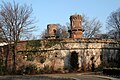
Fortifications and orangery
Parts of the fortress structures have been preserved, such as the main structure with its representative gate and the two round towers, remains of the lunette in the eastern part and in between the later so-called orangery as the remainder of the ammunition depot built deep into the ground in 1841.
Garden view

Throat ditch
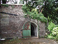
Gate of the bezel


The sickle-shaped protective walls against explosions are still clearly visible. Greenhouses were built for use as a greenhouse. The garden architect was Adolf Kowallek, who was responsible for many other Cologne green spaces. He had his official apartment on the upper floor of the orangery, which had not been rebuilt after the war damage - a small cul-de-sac on the other side of the Vorgebirgstrasse on the Bonn Wall bears his name. The building served as the first institute building for the Botanical Institute of the university, which was re-established in 1919 .
Today the Volksgarten is integrated into the city's green concept. It allows one of the green corridors that connect the two green belts and that radiate into the surrounding area, the green corridor south, starting at the Volksgarten, via the Vorgebirgspark and the Fritz-Encke-Volkspark over the Brühler Schlösser of the Rhineland Nature Park to Bonn.

Today's appearance
The representative town houses built in the Wilhelminian style or Art Nouveau have been restored and are again the best residential area. On the north side of the park, on which there is a street named after the founder Wilhelm Kaesen , is the monument erected by the city.
Since the late 1980s, the Volksgarten has been used as a summer storage area and - permitted by the city - for grilling . According to the city of Cologne, up to 10,000 people visit the park every day.
Web links
Individual evidence
- ↑ History of the Orangery
- ↑ Page no longer available , search in web archives: Chronicle
Coordinates: 50 ° 55 ′ 15.3 " N , 6 ° 56 ′ 48.6" E