Rhineland Nature Park
The Rhineland Nature Park - Kottenforst-Ville Nature Park until 2005 - is a 1,045 km² nature park founded in 1959 between the Rhine plain and the Erft valley west of the cities of Cologne and Bonn . It is one of the largest protected areas in North Rhine-Westphalia and also includes recultivated parts of the Rhenish lignite mining area .
Location and natural structure
The nature park stretches from northwest to southeast over a good 60 km with a width of up to 30 km and touches three districts. Its largest share of the area belongs to the Rhein-Erft district in the north, which is connected to the Euskirchen district in the south . The southeast belongs to the left bank of the Rhine-Sieg district , which surrounds the city of Bonn. The Erft valley between Euskirchen and Bedburg forms the western end.
Of its total area, about half are forest and half are landscape protection areas ; 9% are under nature protection . Cities that are mostly in the area of the nature park are Bedburg , Bergheim , Bornheim , Kerpen , Frechen , Hürth , Brühl , Erftstadt , Zülpich , Euskirchen , Rheinbach and Meckenheim .
Kottenforst

The Kottenforst forms the southeastern part of the nature park with an area of around 40 km². It is a largely flat, largely forested area southwest of Bonn above the Cologne Bay .
The Kottenforst nature park is criss-crossed by a spider-web-like system of paths that is oriented towards the former Herzogsfreude Castle in Röttgen . In the 18th century, Elector Clemens August I of Bavaria had these aisles laid out for the purpose of hunting forces. The hunting lodge has been preserved as a monument to these hunts .
Ville (with promontory)
The Ville is up to 170 m above sea level. NHN high ridge in the middle part of the nature park between Cologne and Bonn . The heap of overburden resulted in new elevations: The now highest elevation of the Ville is the Glessener Höhe at 205.8 m . The ridge is largely forested and is clearly demarcated to the east with a slope of 60 to 100 m towards the Cologne Bay . To the west to the valley of the Erft and to the Voreifel, however, the terrain transition is much more blurred. Geologically, the Ville is a prominent eyrie ; the Cologne Bay and Voreifel have sunk to different depths. More precisely, this is a half-nest, as the Rhine has eroded a bulging slope on the south-east roof of the Ville, the actual promontory . Parts of the foothills, such as the nature reserve around the Augustusburg and Falkenlust palaces in Brühl, are part of the nature park, although the foothills are otherwise intensively used for agriculture.
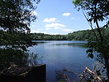
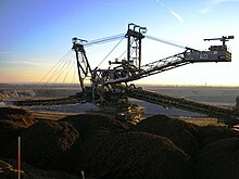
The northern section of the Ville is part of the Rhenish lignite mining area and is characterized by the former open-cast lignite mining and subsequent recultivation . In the area of Erftstadt, Brühl, Bornheim and Hürth, around 40 large and small lakes have been created that are used today for swimming, diving, fishing and relaxing (Ville-Seenplatte). In 1920, Adolf Dasbach near Hürth was the first to start afforestation of his mining area with robinia , beech , pine , red oak and larch .
Northern foothills
In the north, the nature park has several finger-shaped foothills around the towns of Pulheim, Bergheim, Bedburg and Kerpen. There are 5 nature reserves around Kerpen . This lowland forest - and wetland forest areas (with lots of lily of the valley ) are located as an island biotope in and on the edge of the Erft - floodplains . The larger wet forest area of the Bürgewald, which adjoins the nature park to the northeast, around the Hambach opencast mine near Niederzier , will fall victim to lignite mining. The Erftaue with its locks should be particularly cared for. A 5 km long avenue of lime trees is being planted between Gymnich Castle , Gymnicher Mühle and Türnich Castle .
Ville Lake District
Around 40 lakes and ponds of various sizes were created from the remaining holes in various brown coal mines.
The nature park and the Cologne / Bonn city region
The Rhineland Nature Park serves the cities of Cologne and Bonn as a local recreation area. The distance to the outskirts of Cologne is only a little more than 10 km. It can be seen as Cologne's third green belt . Just as the two green belts of Cologne are connected by green corridors, these green axes are also extended to the nature park. The green axis south continues through the open fields between Ville and Rhine with the interspersed nature reserves around Brühl to Bonn. The green axis West connects as the green axis Rhein-Erft the city forest and the sports facilities in Cologne-Müngersdorf with Frechen-Königsdorf and the recultivation areas of the middle Ville. The north green axis connects the Cologne green belt with the northern parts of the nature park and the green areas between Bergheim and Grevenbroich .
History of the park
General

The history of the park began in 1959 with the establishment of the Kottenforst Nature Park from the Kottenforst and the adjacent Rheinbacher Wald. After the Siebengebirge nature park, this was the second nature park in North Rhine-Westphalia and one of seven in the Federal Republic of Germany. The idea of a nature park was only shortly before that in 1956 by the nature conservationist and patron Dr. Alfred Toepfer was propagated in Bonn. In 1965, the Ville recreation park was founded by the neighboring districts and cities, the Rhineland Regional Council and Rheinbraun AG . In 1967 the recultivated areas of the recreation park were combined with the nature park to form the Kottenforst Ville nature park under the sponsorship of the Cologne administrative district. In 1978, the Kottenforst Ville Nature Park Association was founded with the members City of Bonn, Rhein-Sieg District, Euskirchen District, Rhein-Erft District, City of Cologne and, as the successor to Rheinbraun, RWE Power . In 1986 the current boundaries of the park were set by the state of North Rhine-Westphalia. In 2005, the association's assembly decided to rename the Rhineland Nature Park , which came into effect on December 12 of the same year. It is hoped that this will lead to a better local assignment of the park and easier tourist marketing. Since 2006 the nature park has been planning a cooperation with the Ria Formosa nature park near Olhão in the Algarve in Portugal .
Awards
When Auslobung a competition to the natural park of 2009 for the 14 Nordrhein-Westfalen Natural Park of the Park was in May 2008, together with the Teutoburg Forest / Egge Hills Nature Park win a first prize and project funding, each 435,000 euros.
Flora and fauna
There are numerous old "head beeches" on the Venusberg on Dottendorfer Allee. The beeches , which used to be "decapitated" at chest height for quick firewood production , took on an extremely bizarre growth form with increasing growth, which also earned them the nickname "ghost beeches ". The many damp spots in the Kottenforst allow lilies of the valley and anemones to sprout. Otherwise there is a mixed forest in addition to the usual spruce plantations.
The agile frog is found in an isolated island occurrence in the nature park among animals that are strictly protected in accordance with the Fauna-Flora-Habitat Directive . He is on the red list in Germany . So far, the sites have been found in the areas with waterlogging in the Kottenforst and the natural shallow lakes near Brühl.
Tourist development
The nature park is made accessible through the following tourist routes that touch or cross the nature park:
- Erft cycle path from the source near Holzmülheim to the confluence with the Rhine near Neuss
- Route of Energy from Paffendorf Castle to Grevenbroich and the Hambach opencast mine
- Roman Canal hiking trail , from Nettersheim to Cologne, which crosses the park between Kottenforst and Hürth
- Kaiser route from Aachen to Paderborn, runs along the Erft
- The moated castle route also affects the castles on the Erft
- The Rhine-Erft adventure route leads from Cologne along the west green axis via Frechen to the Kerpen nature reserves
- Villeweg from Birkhof in Brühl to Kottenforst station on the Voreifelbahn (22 km)
- Kottenforst route from Kottenforst station as a western circular route to Heimerzheim and back (30 km) and as an eastern circular route to Meckenheim and Villip (32 km), two shorter circular routes of 7 and 13.5 km, which are also suitable for the disabled, are also available signposted
- Fire route , 33 km long themed hiking trail between Rheinbach and Wachtberg
The following circular routes are recommended for those arriving by car or public transport:
- Lake circuit (17.7 km), around Liblarer See, Bleibtreu See and Heider Bergsee, on both sides of the Luxemburger Straße. Bus 979 (Köln Hbf line 18 to Hermülheim ) Abzw. Brühl-Heide , or Liblarer See
- Klüttenweg (16.8 km), circular route through the oldest recultivated pits between Walberberg ( Berggeistsee ) and the Swisterberg tower near Weilerswist . Motorway exit Phantasialand -strasse
- Otto-Maigler-Runde (10.2 km), around the Otto-Maigler-See between Alt-Hürth and Berrenrath . Bus 978 (Köln Hbf) or 960 ( Frechen ) to Hürth-Burbach City bus 711 to Zur Gotteshilfe, parking lot there and at the outdoor pool (chargeable in the season) and at Burbach Abbey
Attractions
Outside the cities:
- The Roman Eifel aqueduct is still largely present on the Villerücken.
-
Railway stations :
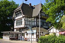
- The reception building of the Kottenforst station, located away from localities on the Voreifelbahn Bonn - Euskirchen , is a large, decorative half-timbered building.
- The Kaiserbahnhof in Brühl- Kierberg on the Eifelbahn ( Cologne - Euskirchen - Gerolstein - Trier ) was splendidly designed in 1875 so that Kaiser Wilhelm I could set out from there to visit the Eifel.
- Iron man : legendary iron stake in the forest near Swisttal - Buschhoven or Dünstekoven
- Phantasialand near Brühl : large amusement park in the Ville recultivation area
- Tomburg near Rheinbach
- Kaster : The medieval old Kaster (now part of Bedburg) was spared from open-cast mining .
- Marienfeld with "Papsthügel": The area for the final event of the World Youth Day 2005 with a capacity for over 1,000,000 pilgrims was in the recultivation area of the Frechen opencast mine near Kerpen .
- the imperial oak , which was planted by the future Kaiser Wilhelm II when he was still a prince
Information centers
The information center and administration of the nature park are located in the nature park center Himmeroder Hof in Rheinbach . In the northern part of the park, the Gymnicher mill between Gymnich and Türnich is being expanded into an information center on mill culture in the northern Rhineland; there is also information about the park there. The nature park has an informative website.
The information center for brown coal of RWE Power in Paffendorf Castle on the edge of the nature park, whose educational trail on brown coal vegetation in the castle park belongs to the street of garden art between the Rhine and Maas , provides information in its exhibitions and in its theme street , street of energy , also about the recultivation of the Rhenish lignite mining area , which includes part of the nature park.
See also
literature
- Werner D'hein: Kottenforst. 13 hikes through a historical cultural landscape . Gaasterland Verlag, Düsseldorf 2008, 128 pages, ISBN 978-3-935873-21-5
Web links
|
Further content in the sister projects of Wikipedia:
|
||
|
|
Commons | - multimedia content |
- Website of the Rhineland Nature Park
- Interactive map of the Rhineland Nature Park with precise borders up to a scale of 1: 3000 (when selecting a topic: select nature parks, then use zoom functions)
Individual evidence
- ↑ a b c d e f section history , on naturpark-rheinland.de (official homepage)
- ↑ Size section , on naturpark-rheinland.de (official homepage)
- ↑ Map services of the Federal Agency for Nature Conservation ( information )
- ↑ Kölner Stadtanzeiger, Rhein-Erft of October 24, 2006
- ↑ Kölner Stadtanzeiger, Land / Region p. 9 of 17./18. May 2008 and park website
- ^ Nabu: Extension (Phantasialand) threatens agile frog, in Kölner Stadtanzeiger, Rhein-Erft, March 19, 2008
Coordinates: 50 ° 49 ′ 10 ″ N , 6 ° 51 ′ 10 ″ E


