
Roman Canal hiking trail

The Römerkanal hiking trail is a hiking trail along the Eifel aqueduct built by the Romans in the 1st century AD . It runs from Nettersheim via Kall , Rheinbach , Brühl and Hürth to Cologne-Sülz and has a length of 116 km. The hiking trail was opened in 1988 for the 100th anniversary of the Eifelverein , and was fundamentally modernized in 2012.
Signage

During the modernization in 2012, the hiking trail was provided with a modern signage system. Around 50 display boards along the way provide information about local features and the construction of the water pipe. Waymark is a stylized cross section of the vaulted canal in black on a white background. A current pocket guide or a current archaeological hiking guide from the Eifelverein with printed map excerpts showing the course of the hiking trail, which was renewed in 2012, are an indispensable companion for hikes. Various restaurants and overnight stays invite you to stop off. The Freundeskreis Römerkanal, in which all neighboring communities and responsible institutions are represented, bundles the activities for the maintenance and marketing of the building. He also runs his own events.
Sights along the way
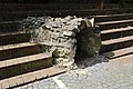
Well room "Grüner Pütz"
The Romans first opened up the sources at Kallmuth, Urfey and Dreimühlen and later expanded this system in a second construction phase with a fourth line to the “Grünen Pütz” in the Urft valley near Nettersheim. This spring version was the beginning of the Eifel aqueduct , also known as the Roman Canal, built at the end of the 1st century AD . Although there is a parking lot at Green Pütz, the hiking trail starts at the Eifel Nature Center in Nettersheim and leads to Green Pütz and then along the pipeline route in Urfttal to an interesting outcrop at Dalbenden Castle.
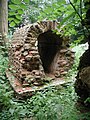
Exposure of the Eifel aqueduct at Dalbenden Castle
On the northern slope of the Urft valley near Dalbenden Castle in Urft, there was a passage, which is still completely preserved today, of the pipe, which had been above ground for a short distance at this point since ancient times. This passage should protect the canal from being washed away by the water of a small dry valley. The hiking trail now leads past the Stolzenburg and then on via Sötenich , Keldenich and Dottel . Keldenich lies on the watershed of Urft and Erft . In Kall , the Eifel aqueduct passed this watershed. The hiking trail now leads past one of the headwaters of the Roman Canal, the Urfey headwaters, to the small, but important aqueduct bridge in Mechernich-Vollem because of its good state of preservation.
Aqueduct bridge in Mechernich-Vollem
Shortly before the pipeline from the Urfey headwaters met the Kallmuther and Nettersheimer pipeline, the canal crossed the ancient Kallmuther Bach over a small aqueduct bridge that is still well preserved today. This bridge structure is located between the towns of Urfey and Vollem and can be visited again today. The small aqueduct bridge is now station 9 of the hiking trail that was renewed in 2012.
Klausbrunnen well room
In another headwaters of the Eifel aqueduct 700 m east of Kallmuth , a reconstructed well room can be visited again, the Klausbrunnen. Before the later expansion of the canal to the Grünen Pütz, it was the outermost point of the Roman aqueduct to Cologne.
Collection basin in Mechernich-Eiserfey
In Eiserfey, a round collecting basin can be viewed, into which, in addition to the pipeline from Nettersheim (Grüner Pütz), Kallmuth (Klausbrunnen) and Urfey, a second canal from the headwaters “Hausener Benden” opens near Weyer. From the collecting basin, the water in the Eifel aqueduct was transported on to Cologne. The hiking trail now leads through the Veybach valley to the aqueduct bridge in Vussem.
Aqueduct bridge near Vussem
In order to cross a now nameless side valley of the Veybach , an approx. 80 m long and up to 10 m high aqueduct bridge was built near Mechernich- Vussem . Today you can see a partial reconstruction with three of the formerly probably twelve arches.
Outcrops at Mechernich-Breitenbenden
On the right slope of the Krebsbach valley you can find an outcrop of the Eifel aqueduct with manholes. Manholes were particularly numerous on this section of the pipeline, as the Romans had to deal with geological problems that made the pipeline susceptible to repair. Here are the remains of Roman buildings near the Roman Canal.
Outcrops at Euskirchen-Kreuzweingarten
The outcrop on the “Am Römerkanal” road is known for its massive calcareous sinter deposits. The restored foundations of a small Roman building can be viewed at another outcrop in Kreuzweingarten . It is believed that there was a small temple here.
- Sections and systems of the water pipeline in northern and Voreifel

The well room at Grünen Pütz

Outcrop of Urft with a small aqueduct bridge

Aqueduct bridge near Vussem

Outcrop at Kreuzweingarten

Section in Buschhoven


From Kreuzweingarten to Rheinbach
From Kreuzweingarten, the hiking trail runs past the Hardtburg , a castle from the 12th century, which was built using building materials from the Eifel aqueduct, past Niederkastenholz . In addition to building materials, even sintered lime plates were used in the church of St. Laurentius . In addition, in Niederkastenholz in the sidewalk you can find Roman buttress stumps of a water pipe, which, however, was probably not connected to the Eifel water pipe. The hiking trail continues via Palmersheim to Rheinbach , where a section of the canal has been set up at the Aachener Straße roundabout, which was recovered in Rheinbach and whose bottom and cheeks are made of Roman stamped concrete. Another section is in Pützstrasse and comes from Mechernich-Breitenbenden. Construction material from the Roman Canal was also used again on the Wasemer Tower and the Hexenturm in Rheinbach.
From Rheinbach to Hürth
In front of Lüftelberg there was a 1400 m long and up to 11 m high aqueduct bridge to cross the Swistbach , which was completely demolished in the Middle Ages. At station 35 of the hiking trail there is a replica of the piers of the aqueduct bridge, which is in the wrong location, but gives an approximate impression of the structure. The hiking trail continues via Lüftelberg and Buschhoven into the Kottenforst , where at station 40 there is a medieval excavation ditch that was created through the extraction of building material. The Roman Canal hiking trail continues via Brühl to Hürth .
Outcrops at Buschhoven

Station 38 of the hiking trail is on the edge of the forest above the Swist valley. It is an outcrop of the Eifel aqueduct, which the Romans laid particularly deep in the ground. Since the line has only overcome the ridge of the ( Ville ) at this point , the gradient in this area is only 0.12%. In 1938, an entry shaft for the pipeline was excavated near station 38, which was then backfilled with earth to secure it.
The water pipes in Hürth and the outcrop in Hürth-Hermülheim
As early as the first half of the 1st century AD, the Romans had supplied their administrative capital of Lower Germany, with around 30,000 inhabitants, with water from several sources on the edge of the foothills . These converged at Hermülheim Castle . The exact location has not yet been found. The collecting line for the springs from the foothills of the foothills from Hürth - Hermülheim was increased - as it was no longer sufficient to supply the city. At the secondary school in Hermülheim there is an accessible excavation site, which clearly shows the approach of the Roman engineers.
Within Hürth, the path runs from the Brühler water tower via Fischenich and Kendenich through the recultivated area of the former Franziska lignite mine, crossing Luxemburger Strasse towards Trierer Strasse. This leads to Brabanter Platz. Here the path meets the route of the older Hürth line from the Hürth valley of the Duffesbach . A section of the line is set up here. The Kreuzstraße lies in the route of the former maintenance route of the line. Another excavated section has been set up at the town hall. At the church, turn left into Deutschherrenstrasse to the castle park of the former Hermülheim castle , where the foothills were brought together. From there, the hiking trail goes along the Duffesbach and immediately past the exposed pipe at the secondary school, then on through Efferen to the Cologne green belt . The stream in its dead straight bed is the successor to the former aqueduct. The creek used to flow straight out in Hermülheim, where it makes an unnatural right-angled kink, and seeped away at Kalscheuren .
- Sections and systems of the water pipeline in the Hürth area

Brabanter Platz
Back of the town hall and town hall

Exposure in Hermülheim
Canal fragment on the Hürth / Cologne border


The line in Cologne
From the underpass under the federal autobahn 4 at the former Schleifkotten-Mühle , where the creek runs above ground again to the military ring, the path leads along the creek to the excavated desludging system with a protective roof at the level of the 1. FC Köln sports park (Refreshment possibility). On the Cologne section of Berrenrather Strasse, a remnant of the pipeline's pillars have been erected. This is followed by another reference to the Roman Canal at the level of Manderscheider Platz at the school opposite. A last section of the ancient aqueduct was set up at the level of the former confluence of Berrenrather Strasse in Zülpicher Strasse (at number 47). Although the line led further into the center of the city on the Marsilstein, one may set the end of the hiking trail here.
Mud trap in the green belt

Cologne-Sülz, Berrenrather Strasse

Cologne, Zülpicher Strasse 47

Drususgasse / At the law school. Section from Hürth


.JPG)
Hiking hostels
Some of the hiking hostels near the path include:
- Youth hostel Nettersheim (operated by the municipality of Nettersheim )
- Youth hostel Naturfreundehaus Kendenich / Villehaus in Hürth (run by Naturfreunde )
- Youth hostel Haus Rheinbach (run by the State Vocational College for Glass Ceramics Design)
literature
- Klaus Grewe : The Römerkanalwanderweg. An archaeological hiking guide . Text tape and card tape. Published by the Eifelverein in 1988 in cooperation with the Rhineland Regional Council, Rheinisches Amt für Bodendenkmalpflege. Verlag des Eifelverein, Düren 1988, ISBN 3-921805-16-3 .
- Klaus Grewe: The Roman Canal Hiking Trail: An archaeological hiking guide. Eifelverein, Düren 2005, ISBN 3-921805-16-3 .
- Klaus Grewe and Manfred Knauff: The long leadership of the Romans. The Römerkanal hiking trail Nettersheim-Cologne. Eifelverein, 2012, ISBN 978-3-921805-81-7 .
- Klaus Grewe: Aqueducts. Water for Rome's cities. The big overview - from the Roman Canal to the aqueduct marble. Regionalia Verlag GmbH, Rheinbach 2014, ISBN 978-3-95540-127-6 .
- Ingrid Retterath: Germany: Roman Canal hiking trail . Conrad Stein Verlag, Welver 2008, ISBN 978-3-86686-240-1 .
Web links
- www.roemerkanal-wanderweg.de - official website of the hiking trail
- Roman Canal Hiking Trail (PDF)
- NRW Foundation - Brief description of the hiking trail
- Illustrated detailed description
- Roman Canal hiking trail on Google Maps
- Freundeskreis Römerkanal e. V. Accessed January 21, 2016 .
- Bike tour in the Cologne-Bonn region: Roman canal hiking trail from Meckenheim to Cologne
Individual evidence
- ^ Klaus Grewe: Aqueducts. Water for Rome's cities. The big overview - from the Roman Canal to the aqueduct marble. P. 390
Coordinates: 50 ° 52 ′ 15 " N , 6 ° 52 ′ 5.6" E