
Green Pütz

Green Puetz is the corridor designation of a flood plain in Urfttal in the district Nettersheim .
One of the spring taps of the Roman Eifel aqueduct is located here , which supplied the Colonia Claudia Ara Agrippinensium , ancient Cologne , with drinking water. The Mechernicher mountain Officials CA Eick pointed mid-19th century archaeological after that the Green Puetz was the extreme point of the Eifel Aqueduct. The source catchment and the adjoining canal up to the railway embankment are now in operation again. However, the water flows behind the embankment, i.e. H. still in the valley, in the Urft.
There is a parking lot for visitors to the Grüner Pütz near the former Gronrecht mill, also known as the "Rosenthaler Mühle".
Eifel aqueduct
The spring connection consisted of an 80 m long seepage water pipe, which collected the spring water at the foot of the valley slope and passed it on to a well room, in which the water was clarified before it was transported on to Cologne in the canal. The spring version was only excavated by W. Haberey in 1952 . The restoration took place in 1975.
The seepage water pipe consisted of dry masonry, which was permeable to water on the slope side and was only sealed with clay on the outside of the cheek facing the Urft , so that no water was lost and no river water could penetrate the Urft. The bottom of the seepage water pipe consisted only of gravel . There were sandstone slabs on the line. The width of the seepage water pipe was 40 to 45 cm, the height 70 cm to 100 cm, increasing towards the well.
The almost square foundation of the well room consisted of sandstone blocks and had the clear dimensions 1.93 m × 1.86 m. The bed, made of gravel, was 15 cm deeper than that of the seepage water pipe and the canal beginning on the other side of the well. On the mountain side, there were also two openings in the well room through which spring water could flow in. In the well room, the flow rate of the water slowed down so that impurities could settle on the floor. Like the seepage water pipe, the well room was also provided with a 30 to 40 cm thick clay seal on the side facing the Urft. Today's reconstruction of the well room has an opening on the valley side, which did not exist in antiquity, through which one can see how the structure works today. Semicircular capstones closed it off at the top. A corresponding corner piece with a Medusa or Gorgon head was found in the well room during the excavation .
The canal, which transported the water collected in the well room to ancient Cologne, consisted of a channel made of cast concrete on which there was a vault made of limestone and greywacke, which sealed the pipe at the top. The inside of the canal was sealed with reddish water plaster and had a clear width of 50 cm and a clear height of 90 cm.
The seepage water pipe, the well room and the adjoining canal are stations 1 and 2 of the Roman canal hiking trail from Nettersheim to Cologne, which was renewed in 2012 .
Roman road Trier – Cologne
Above the parking lot at the former Gronrechtsmühle, a footpath runs in a serpentine shape on the southern slope of the valley on the former route of the Roman road Trier – Cologne (Agrippastraße).
It is part of this Roman highway from Trier via Jünkerath , Marcomagus and Zülpich to Cologne. After the ancient traveler coming from Zülpich had crossed the Urft, he drove this serpentine (50 ° 30'40 "N; 6 ° 36'45" E) , some of which still exists as a ravine today, and came to the Nettersheim-Marmagener Plateau and finally reached the Görresburg behind the Schleifbachtal near Nettersheim , which was at the beginning of a Roman vicus (probably with the name Marcomagus).
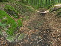
Pictures from the valley floodplain

View from the east into the "Grüner Pütz" flood plain in the Urft valley , 3.5 km north of Nettersheim .

The beginning of the seepage line on the south side of the valley floodplain.

Part of the drainage line developed for tourism.

The Roman well room. The enclosure was rebuilt in the early 1970s.

Medusa head at the Roman fountain (original in the Landesmuseum Bonn)

The half-timbered building at the southern entrance to the Talaue is the rest of the so-called Gronrechtsmühle, a water-powered grain mill from the 18th century.
Serpentine of Agrippastraße in the slope of the Urfttal near Nettersheim above the Grüner Pütz with clear ruts in the rock below left


literature
- CA Eick : The Roman aqueduct from the Eifel to Cologne with regard to the Roman settlements, fortifications and military roads that were initially located. A contribution to antiquity in the Rhineland. With a card. Max Cohen & Sohn, Bonn 1867, pp. 26–28 .
- Klaus Grewe : Atlas of the Roman water pipes to Cologne (= Rhenish excavations. Volume 26). With contributions by Werner Brinker, Günther Garbrecht, Hansgerd Hellenkemper , Heinz-Otto Lamprecht, Horst D. Schulz , Edgar Thofern. Rheinland-Verlag, Cologne 1986, ISBN 3-7927-0868-X , p. 38 ff.
- Klaus Grewe: Aqueducts. Water for Rome's cities. The big overview - from the Roman Canal to the aqueduct marble. Regionalia Verlag, Rheinbach 2014, ISBN 978-3-95540-127-6 , p. 265 ff.
- Klaus Grewe: Nettersheim: Roman source version. In: Heinz Günter Horn (Ed.): The Romans in North Rhine-Westphalia . Konrad Theiss Verlag, Stuttgart 1987, ISBN 3-8062-0312-1 , p. 577 f.
- Klaus Grewe: Two Roman roads south of the Urft. In: Archeology in the Rhineland 2001 . Published by the Rhineland Regional Council, Rheinisches Amt für Bodendenkmalpflege by Harald Koschick. Konrad Theiss Verlag, Stuttgart 2002, ISBN 3-8062-1751-3 , p. 62 ff.
- Klaus Grewe: The Agrippastraße between Cologne and Trier. In: Jürgen Kunow (Ed.): Adventure space Römerstraße Cologne-Trier. Erftstadt Colloquium 2007 . (= Materials for the preservation of monuments in the Rhineland. Issue 18). A publication of the Rhineland Regional Council, Rheinisches Amt für Bodendenkmalpflege. 2007, ISBN 978-3-9806426-9-9 , p. 49 f.
- Klaus Grewe: The Römerkanalwanderweg. An archaeological hiking guide (= guide to archaeological monuments in the Rhineland. Volume 1). Text tape. Published by the Eifelverein in 1988 in cooperation with the Rhineland Regional Council, Rheinisches Amt für Bodendenkmalpflege. Verlag des Eifelverein, Düren 1988, ISBN 3-921805-16-3 , p. 20 ff.
- Klaus Grewe, Manfred Knauff: The long leadership of the Romans. The Römerkanal hiking trail Nettersheim-Cologne. Publisher: Eifelverein eV 1st edition 2012. ISBN 978-3-921805-81-7 , p. 148 ff.
- Waldemar Haberey : The Roman water pipes to Cologne. The technology of water supply in an ancient city (= art and antiquity on the Rhine. No. 37). 2nd Edition. Rheinland-Verlag u. a., Bonn 1972, ISBN 3-7927-0146-4 , p. 64 ff.
- Waldemar Haberey: The Roman Eifel aqueduct to Cologne. In: Northeastern Eifel foreland - Euskirchen, Zülpich, Bad Münstereifel, Blankenheim. Part I: Introductory essays (= Römisch-Germanisches Zentralmuseum Mainz et al. (Hrsg.): Guide to prehistoric and early historical monuments. Volume 25). Verlag Philipp von Zabern, Mainz am Rhein 1974, p. 79 ff.
- Heinz Günter Horn: Agrippastraße Cologne-Trier. Section Nettersheim. Of serpentines, temples and guard stations. 1st edition. JP Bachem Verlag, Cologne 2011, ISBN 978-3-7616-2365-7 , p. 25 ff.
- Antonius Jürgens: Practical ground monument maintenance: excavations and restorations of archaeological monuments in the community of Nettersheim. In: District Euskirchen (Hrsg.): Yearbook of the District Euskirchen 1978. S. 136 ff.
- Antonius Juergens, Marianne Juergens: Prehistory and early history. Stone Ages - Metal Ages - Romans - Franconia. In: Eifelverein (Ed.): Nettersheim community with the towns of Bouderath, Buir, Engelgau, Frohngau, Holzmülheim, Marmagen, Nettersheim, Pesch, Roderath, Tondorf, Zingsheim. History, geology, flora and fauna, economy, legends, sights, hiking suggestions (= series of publications: "The beautiful Eifel". Nettersheim edition). 1st edition. 1984, ISSN 0342-5819 , p. 64 ff.
- Rudolf Pörtner : With the elevator to Roman times . Cities and sites of early German history. Econ Verlag, Düsseldorf / Vienna 1959, ISBN 3-430-17529-1 , p. 434 ff .
Individual evidence
- ↑ Eick published his discovery in 1867 in his work The Roman Aqueduct from the Eifel to Cologne with regard to the Roman settlements, fortifications and military roads that were initially located.
- ↑ Klaus Grewe, Manfred Knauff: The long leadership of the Romans. The Römerkanal hiking trail Nettersheim-Cologne. 2012, p. 148 ff.
Coordinates: 50 ° 30 ′ 44 ″ N , 6 ° 36 ′ 30 ″ E