
Urft (river)
| Urft | ||
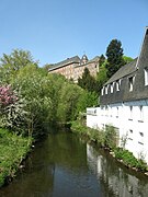
 The Urft near Gemünd in the Urftstausee at low water |
||
| Data | ||
| Water code | EN : 2822 | |
| location |
Eifel
|
|
| River system | Rhine | |
| Drain over | Rur → Maas → Hollands Diep → North Sea | |
| River basin district | Meuse | |
| source | in the northern Eifel near Schmidtheim 50 ° 25 ′ 5 ″ N , 6 ° 30 ′ 12 ″ E |
|
| Source height | approx. 581 m above sea level NHN | |
| muzzle | near Rurberg in the Rur / in the Obersee of the Rurtalsperre Coordinates: 50 ° 36 '8 " N , 6 ° 25' 7" E 50 ° 36 '8 " N , 6 ° 25' 7" E |
|
| Mouth height | 279.6 m above sea level NHN | |
| Height difference | approx. 301.4 m | |
| Bottom slope | approx. 6.5 ‰ | |
| length | 46.4 km | |
| Catchment area | 372.564 km² | |
| Discharge at the Gemünd A Eo gauge: 344.55 km² Location: 14 km above the mouth |
NNQ MNQ 1951-2017 MQ 1951-2017 Mq 1951-2017 MHQ 1951-2017 HHQ |
191 l / s 944 l / s 4.673 m³ / s 13.6 l / (s km²) 69.483 m³ / s 142.92 m³ / s |
| Left tributaries |
Olef (this and others see below ) |
|
| Right tributaries |
Genevabach (this and others see below ) |
|
 The Rur u. a. with courses from Urft, Inde , Merzbach and Wurm |
||


The Urft is a 46.4 km long right tributary of the Rur in the North Rhine-Westphalian district of Euskirchen . In the municipality of Kall there is the village of Urft , which the Urft flows through.
Origin of name
The name of the Urft has made "Urd- apa developed". The origin of the word “Urd” is not yet known, “apa” is Celtic and means Bach. The Urft was named "Urdefa" in 1075, "Orfft" in 1419 and "Oyrfft" in 1503. The place Urft derives its name from the river.
geography
course
The Urft rises in the northern Eifel region in the High Fens-Eifel at an altitude of about 581 meters above sea level. NHN . Its source is in the Dahlem Forest , 3.8 km west of the Dahlem district of Schmidtheim and 2.3 km (as the crow flies ) northwest of the Dahlemer Binz airfield .
Initially the Urft flows through Schmidtheim, from where it is accompanied by the Eifel route and after which the Dänenbach flows into it, and through Blankenheim-Wald , where it takes up the Wisselbach and is crossed by the federal road 258 . After that the Treisbach, Laufbach and Haubach flow to it. At the Steinrütsch, which is in the district of Nettersheim and where the remains of a castle and a small fort are located, the Wellenbach flows into the Urft and in Nettersheim the Genevabach. Then the river runs - parallel to the Roman Eifel aqueduct that begins at the former Gronrechtsmühle on Grünen Pütz - through Urft , where the Gillesbach flows into, and below the village the Kuttenbach . The Urft then runs through Sötenich and Kall , where both the Eifel route and the Eifel aqueduct leave it and which takes the Kallbach in order to run along the Oleftalbahn and through Anstois . Then it passes Gemünd , where the Olef joins and in the village the federal highways 265 and 266 cross the Urft. There it leaves the Oleftalbahn and then flows through Malsbenden .
Subsequently, the Urft flows into the Urftstausee a, the underlying ridge its water usually in the north of the reservoir Kermeter by the Kermeterstollen and through the turbines of the power plant Heimbach with thereat of outflow in the equalization tank the dam Heimbach passes and thus into the Rur. Due to this artificial tunnel drainage, the Urft estuary was relocated to the vicinity of the Rur 111.1 km south of the Heimbach district of Hasenfeld . Before the construction of the Urft dam wall , the river flowed naturally into the Rur above the Simmerath district of Rurberg at about Rur-km 123.5. Since the 2nd expansion stage of the Rursee in 1959, the water from the upper lake of the Rurstausees there has overflowed the old (near the mouth) lower reaches of the Urft on the air side of the Urft dam by 12 m. The reservoir water flows there in flood situations over the weir of the Urft dam.
Catchment area
The Urft catchment area in the North Eifel is 372.564 km² and drains into the North Sea via the Rur, Maas and Hollands Diep .
It borders
- in the north to that of the small Rur tributaries Eschbach , Hohenbach and Büdenbach
- in the northeast of the Steinbach , Herbstbach and Heimbach , all of which are also smaller tributaries to the Rur
- on the east of the Rhine tributary Erft
- in the southeast to the Ahr , also a tributary of the Rhine
- on the south by the Kyll , which is a tributary of the Mosel is
- in the southwest of the Amel tributary Warche and the Rur tributary Perlenbach
- in the west to that of the Rur tributary Erkensruhr
- and in the northwest to that of the Elfesbach , also a tributary of the Rur.
The highest point is the Bärbelkreuz ( 662.8 m ) in the south of the catchment area.
Tributaries
- Main strand
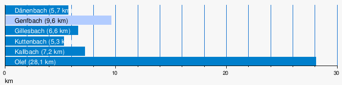
By far the largest tributary of the Urft is the Olef.
| Comparison Urft to Gemund / Olef | |||
|---|---|---|---|
| Surname |
Length (km) |
EZG (km²) |
MQ (m³ / s) |
| Urft to Gemund | 34.7 | 145.018 | 1.68 |
| Olefin | 28.1 | 196.076 | 3.37 |
The comparison between Urft and Olef at the confluence in Gemund shows that from a hydrological point of view the olef belongs to the main branch of the Urft river system up to that point, while the longer Urft upper course is a subsidiary branch of it.
- Tributaries longer than 5 km
The tributaries on the left are shown in dark, the ones on the right in light blue.
Tributaries from the source to the mouth
| Tributaries of the Urft | |||||||
|---|---|---|---|---|---|---|---|
|
GKZ |
Surname |
Length (km) |
EZG (km²) |
MQ (m³ / s) |
direction |
Mouth (at km) |
Mouth (at site) |
| 2822112 | NN | 1.7 | 1.139 | 0.02 | Left | 43.8 | |
| 2822114 | NN | 2.5 | 1.767 | 0.03 | Left | 43.6 | |
| 2822116 | NN | 1.9 | 1.202 | 0.02 | right | 43.7 | |
| Hermesiefen | 0.4 | Left | 42.7 | Schmidtheim | |||
| Nonnenbach | 0.7 | Left | 41.4 | Schmidtheim | |||
| 282212 | Dänenbach | 5.7 | 4,784 | 0.06 | Left | 40.1 | Schmidtheim |
| 2822132 | Zehnbach | 1.3 | 2,598 | 0.03 | right | 39.5 | |
| 282214 | Wisselbach | 3.5 | 2,314 | 0.03 | Left | 38.3 | Blankenheim forest |
| 2822152 | Schaferbach | 1.7 | 1.713 | 0.02 | right | 37.8 | Blankenheim forest |
| 2822154 | Scheidsiefen | 0.9 | 0.823 | 0.01 | right | 37.1 | |
| 2822156 | Treisbach | 2.8 | 1,783 | 0.02 | Left | 36.2 | |
| 282216 | Haubach | 3.4 | 7.057 | 0.07 | right | 35.2 | |
| 2822172 | Laufbach | 2.2 | 1.619 | 0.02 | Left | 34.9 | |
| 2822174 | Lützert soaps | 1.5 | 0.555 | 0.01 | right | 34.5 | |
| Greuer Siefen | 0.5 | Left | 34.3 | ||||
| 2822176 | Gelensiefen | 1.4 | 0.858 | 0.01 | Left | 33.3 | |
| 2822178 | Wellenbach | 2.5 | 2,371 | 0.02 | right | 31.7 | |
| 282218 | Schleifbach | 3.9 | 3,961 | 0.04 | Left | 30.8 | Nettersheim |
| 28222 | Genevabach | 9.6 | 20.102 | 0.19 | right | 29.4 | Nettersheim |
| 28224 | Gillesbach | 6.6 | 15.644 | 0.19 | Left | 23.2 | Urft |
| 282252 | Kuttenbach | 5.3 | 4.488 | 0.06 | Left | 22.3 | Urft |
| 28226 | Kallbach | 7.2 | 15.007 | 0.19 | Left | 18.4 | Call |
| 282272 | (Bach at the foxholes ) | 1.7 | 0.960 | 0.01 | right | 16.8 | Call |
| 2822732 | Fahrbach | 2.8 | 2.039 | 0.02 | Left | 16.7 | Call |
| 28227392 | Dränkensief | 1.6 | 1.195 | 0.01 | Left | 16.2 | Kall- Anstois |
| 282274 | (Bach at the master mill) | 1.4 | 1,785 | 0.02 | right | 16.2 | Anstois master mill |
| 282276 | (Bach Im Rödchen ) | 1.4 | 0.665 | 0.01 | Left | 15.2 | |
| Mittelbach | 0.4 | right | 13.5 | ||||
| 282278 | Mühlenbach | 1.3 | Left | 13.1 | |||
| 2822792 | Seelbach | 0.9 | 0.940 | 0.01 | right | 13.1 | Gemünd |
| Sprengelbach | 0.4 | right | 12.5 | Gemünd | |||
| 28228 | Olefin | 28.1 | 196.073 | 3.37 | Left | 11.7 | Gemünd |
| 2822918 | Braubach | 3.5 | 2.573 | 0.03 | Left | 11.3 | Gemünd |
| 2822914 | Great Scheuerbach | 1.1 | 1,382 | 0.01 | right | 11.1 | Gemünd |
| 2822912 | Lompig | 1.1 | 0.589 | 0.01 | right | 10.5 | Gemünd |
| 2822992 | Horrenbach | 1.8 | 1.1 | Left | 9.4 | Gemünd | |
| 28229936 | Lassbach | 2.3 | 2.175 | 0.03 | Left | 8.2 | |
| 2822994 | Great Böttenbach | 3.0 | 2,440 | 0.02 | right | 7.1 | |
| 28229952 | Morsbach | 2.3 | 2.062 | 0.03 | Left | 6.3 | |
| 2822996 | Lorbach | 3.0 | 2.816 | 0.03 | right | 4.9 | |
| 28229972 | Amselbach | 2.1 | 1.346 | 0.01 | right | 4.8 | |
| 28229974 | Hohenbach | 1.6 | 1.708 | 0.02 | right | 2.8 | |
| 2822998 | (Bach vom Walberhof) | 2.5 | 2.722 | 0.03 | Left | 2.3 | |
| 28229992 | Haftenbach | 0.6 | 0.599 | 0.01 | Left | 0.9 | |
| 2821922 | Walbigbach | 2.2 | 1.376 | 0.02 | Left | ||
| 2821924 | Friedenbach | 1.1 | 0.763 | 0.01 | right | ||
- Tributaries of the Urft

The Geneva stream
The Gillesbach
The olef
The Horrenbach


Urftstausee
By 58.5 m high and 226 m long Urfttalsperre (dam) the Urft becomes 2.16 km² Urftstausee ( Urftsee dammed).
literature
- Hans Peter Schiffer: The Urft Valley in the Eifel. Landscape, nature, history. 2nd Edition. LandpresseRegio, Weilerswist 2006.
Web links
Individual evidence
- ^ German basic map 1: 5000
- ↑ Altitude of the Obersee at the destination
- ↑ a b c d e f Topographical Information Management, Cologne District Government, Department GEObasis NRW ( information )
- ↑ Gemünd level
- ↑ a b c d Hans Peter Schiffer: The Urft valley in the Eifel. Landscape, nature, history. 2006. p. 6.
- ↑ on the Urft estuary see also: Matthias Kufeld, Joachim Lange, Bernd Hausmann: The catchment area of the Rur. (PDF; 10.54 MB) Report on the results of the literature research carried out as part of the AMICE project . June 2010, p. 57 below (from "The water from the Urfttalsperre ...") , accessed on February 15, 2014 .
- ↑ a b Modeled discharge values according to the specialist information system ELWAS, Ministry for Climate Protection, Environment, Agriculture, Nature and Consumer Protection NRW ( notes )
- ↑ Water directory of the State Office for Nature, Environment and Consumer Protection NRW 2010 (XLS; 4.67 MB) ( Notes )
- ↑ Including the tributaries in the Old Urft Course
- ↑ Data on the EZG partly according to ELWAS
- ↑ a b c d e Self-measurement of the length on ELWAS
- Jump off the Urft
- ↑ a b c The GKZs of Braubach, Großer Scheuerbach and Lompig (so the order downstream) violate the numbering system.
- ↑ Self-measurement of the EZG on ELWAS
- ↑ a b c d e f g flows into the Urftstausee
- ↑ a b flows into the Alte Urft (GKZ: 282192)