
Amel (river)
| Amel | ||
 Location of the Amel river in Belgium |
||
| Data | ||
| location | Belgium | |
| River system | Rhine | |
| Drain over | Ourthe → Maas → Hollands Diep → North Sea | |
| River basin district | Meuse | |
| source | at Honsfeld 50 ° 21 ′ 56 ″ N , 6 ° 15 ′ 43 ″ E |
|
| Source height | approx. 591 m | |
| muzzle | in Comblain-au-Pont in the Ourthe coordinates: 50 ° 28 ′ 57 " N , 5 ° 35 ′ 8" E 50 ° 28 ′ 57 " N , 5 ° 35 ′ 8" E |
|
| Mouth height | 95.7 m | |
| Height difference | approx. 495.3 m | |
| Bottom slope | approx. 5.3 ‰ | |
| length | 93 km | |
| Catchment area | 1,075.2 km² | |
| Discharge at the Martinrive A Eo gauge : 1068 km² |
NNQ (1991) MQ 1974/2017 Mq 1974/2017 HHQ (1991) |
1.66 m³ / s 19.19 m³ / s 18 l / (s km²) 329.68 m³ / s |
| Left tributaries | Rechterbach , Lienne | |
| Right tributaries | Warche , L'Eau Rouge , Salm , Le Rubicon | |
| Small towns | Stavelot , Aywaille | |
| Communities | Amel , Stavelot , Trois-Ponts , Stoumont , Aywaille , Comblain-au-Pont | |
The Amel (French: Amblève ) is a tributary to the Ourthe in East Belgium ( Province of Liège ). The Amel is part of the Maas catchment area . Its source is near Honsfeld in the Belgian Eifel , on the border between the municipalities of Amel and Büllingen on 600 m OP tributaries of the Amel are the Warche and the Salm . Le Rubicon is an underground tributary of the Amel. He shaped the Remouchamps caves . Le Rubicon has been accessible to the public at 600 meters in these grottoes since 1912.
The Amel flows through the municipalities of Amel , Stavelot , Trois-Ponts and Aywaille . In the vicinity of Trois-Ponts are the famous waterfalls of Coo . The Amel flows into the Ourthe River at Comblain-au-Pont .
The name Amel is of Celtic origin and means water .
Imagery
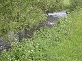
The Amel near Montenau

The Coo waterfalls
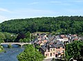
The Amel in Aywaille


Web links
Individual evidence
- ^ Service public du Wallonie: Atlas des Cours d'Eau Non Navigables de Wallonie , accessed on January 8, 2020
- ^ Service public du Wallonie: Atlas des Cours d'Eau Non Navigables de Wallonie , accessed on January 8, 2020
- ↑ Direction générale opérationnelle de la Mobilité et des Voies hydrauliques : Fiche signalétique de Station Martinrive; accessed on January 8, 2020