
Ourthe
| Ourthe | ||
 Location of the Ourthe in Belgium |
||
| Data | ||
| location | Ardennes , Luxembourg Province , Province of Liège , Belgium | |
| River system | Rhine | |
| Drain over | Meuse → Hollands Diep → North Sea | |
| River basin district | Meuse | |
| source |
Headwaters : Eastern Ardennes Ourthe Occidentale: 49 ° 54 ′ 57 ″ N, 5 ° 25 ′ 42 ″ E Ourthe Orientale: 50 ° 11 ′ 44 ″ N, 6 ° 0 ′ 41 ″ E |
|
| Source height |
506 m (O. Occ.), 512 m (O. Or.), 275 m (Union) |
|
| muzzle |
Meuse near Liège Coordinates: 50 ° 37 ′ 22 " N , 5 ° 34 ′ 49" E 50 ° 37 ′ 22 " N , 5 ° 34 ′ 49" E |
|
| Mouth height | 60 m | |
| Height difference | 450 m or 215 m | |
| Bottom slope | 2.5 ‰ | |
| length | 181.2 km = 130.47 (Ourthe) + 50.75 (Ourthe Occ.) | |
| Catchment area | 3624 km² | |
| Outflow A Eo : 3624 km²
|
MQ Mq |
55.2 m³ / s 15.2 l / (s km²) |
| Right tributaries | Aisne , Amblève , Weser | |
| Communities | La Roche-en-Ardenne , Durbuy , Esneux | |
| Navigable | in the lower reaches | |
The Ourthe (German also Urt ) is a river in the east of the Belgian Ardennes . It arises in the province of Luxembourg from two source rivers that join at the border of the municipalities of La Roche-en-Ardenne and Houffalize . The Ourthe is the most water-rich tributary of the Meuse .
The 49.5 km long Ourthe Occidentale (western Urt) rises well 506 m above sea level near the village of Ourt in the municipality of Libramont-Chevigny ( 49 ° 55 ′ 31 ″ N, 5 ° 26 ′ 23 ″ E ) and then flows through it the communes of Sainte-Ode and Tenneville . It is the source flow richer in water (MQ = 7.2 m³ / s). The 38.7 km long Ourthe Orientale (eastern Urt) rises 510 m above sea level between Ourthe, Deiffelt and Beho ( 50 ° 12 ′ 09 ″ N, 5 ° 59 ′ 43 ″ E ), the three traditionally German-speaking villages in the municipality Gouvy . Besides Gouvy it flows through the municipality of Houffalize and its core town.
The association has been located in the Barrage de Nisramont reservoir since 1958 , water level about 275 m above sea level. The Ourthe then flows north-west and then north-east to the confluence of the Amel (Amblève in French), from there northwards and after 165 km joins the Meuse on the right at Liège .
The cities of La Roche-en-Ardenne , Hotton (with the Hotton Caves - famous karst cave), Durbuy (center of one of the smallest cities in the world), Comblain-au-Pont (also with cave) and Esneux . The lower reaches of the Ourthe is navigable, but since the 1920s it has only been used sporadically by ships.
The Ourthe department , which existed from 1795 to 1815, was named after the river .
The three main tributaries of the Ourthe come from the right: the Aisne (not to be confused with the much larger French Aisne ), the Amel (French: Amblève) and the Weser (French: Vesdre).
photos
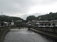
The Ourthe at La Roche

The Ourthe near the town of Hotton


Web links
- Website of the municipality of Gouvy with villages in the headwaters ( Memento from August 4, 2010 in the Internet Archive )
- Atlas de l'Ourthe (PDF 3.85 MB, French)
- Contrat Rivière Ourthe (French)
Individual evidence
- ↑ Determination of length using drawn GPS tracks: