
Nettersheim
| coat of arms | Germany map | |
|---|---|---|

|
Coordinates: 50 ° 30 ' N , 6 ° 38' E |
|
| Basic data | ||
| State : | North Rhine-Westphalia | |
| Administrative region : | Cologne | |
| Circle : | Euskirchen | |
| Height : | 470 m above sea level NHN | |
| Area : | 94.35 km 2 | |
| Residents: | 7491 (Dec. 31, 2019) | |
| Population density : | 79 inhabitants per km 2 | |
| Postal code : | 53947 | |
| Primaries : | 02486, 02253, 02440, 02484 | |
| License plate : | EU, SLE | |
| Community key : | 05 3 66 032 | |
| LOCODE : | DE NHI | |
| Address of the municipal administration: |
Krausstrasse 2 53947 Nettersheim |
|
| Website : | ||
| Mayor : | Wilfried Pracht ( CDU ) | |
| Location of the municipality of Nettersheim in the Euskirchen district | ||
  |
||

Nettersheim is a municipality in the Euskirchen district in the southwest of North Rhine-Westphalia . It was formed on July 1, 1969 due to the law on the reorganization of communities in the Schleiden district from the previously independent communities Bouderath , Buir , Engelgau , Frohngau , Holzmülheim , Marmagen , Nettersheim, Pesch , Roderath , Tondorf and Zingsheim .
The municipal administration is based in Zingsheim. The municipality of Nettersheim was named the federal capital of nature conservation by the German Environmental Aid in 1990 and maintains the Nettersheim Nature Center and the Nettersheim Wood Competence Center in Nettersheim .

The many archaeological ground monuments , especially from Roman times, which are located in the municipality and district of Nettersheim are remarkable .
Parish church
The Catholic parish church of St. Martin is dedicated to St. Consecrated to Martin of Tours . Perhaps there was a chapel in the old cemetery near today's parish church as early as around 800 that was consecrated to Martin, the patron saint of the Franconian Empire.
It has been handed down from 1536 that the Nettersheim chapel belonged to the Zingsheim parish. It was not until 1705 that Nettersheim became an independent parish and the parish church chapel. In 1785 the construction of a new church was completed. In 1966 and 1968 it was extended by two aisles and since then has 400 seats and 100 standing places.
A window in the church, showing the division of the coat of Saint Martin, served as a template for the German Christmas postage stamp 2011 (Bund MiNr. 2895).

Parish Church of St. Martin

Former Sacred Heart Convent

Chapel of the former Sacred Heart Convent


geography

The municipality of Nettersheim is located in the German-Belgian Nature Park North Eifel . Cologne and Aachen are each about 60 kilometers away, Trier is about 100 kilometers away.
The two most important rivers that flow through the municipality are the Urft , into which the Geneva stream flows in the village of Nettersheim , and the Erft . Above all, the Urft with its side valleys, the Erft and the Quartbach shape the relief of the municipality with their valleys. The Erft rises in the Holzmülheim district.
Parts of the Sötenicher and Blankenheimer Kalkmulde , surrounded by series of Lower Devonian rocks, especially the Klerfer strata, belong to the municipality.
Neighboring communities are Dahlem , Hellenthal , Kall , Mechernich , Bad Münstereifel , Hümmel and Blankenheim (Ahr) .
Community structure
The community of Nettersheim consists of the following districts:

nature and landscape
According to the landscape plan that came into force in 2004, almost the entire outer area of the municipality consists of nature reserves and, above all, landscape protection areas.
The community has a very diverse flora.
archeology
In the community of Nettersheim, important ground monuments, especially from Roman times, have been preserved in the relatively largely untouched landscape.
The source of the spring at Grünen Pütz , the Görresburg , the Gallo-Roman temple in Zingsheim and the Villa rustica near Roderath have been restored and reconstructed since 1975 in such a way that interested visitors can understand the function of these systems, which originated in the first centuries after the turn of the times.
In addition, the vicus, which extends from Steinrütsch to Görresburg , has been expanded into an archaeological park: it opened on May 18, 2014. The partially reconstructed Görresburg belongs to it , and in the area of Alte Gasse below the Görresburg some strip houses and a small fort on Steinrütsch are indicated.
prehistory
In the district of Weyer , which borders the community to the north, lies the Kartstein , where many Stone Age finds were made. For example, hunters of the Ahrensburg culture stayed at the Kakushöhle, but presumably also hunted in the Zingsheim area on the Rummerschlegel rock formation , as found in 1972 by Löhr suggest.
The Nettersheim district was also visited by people in the Stone Age , as the discovery of two stone axes shows.
Even in the early days, people lived as hunters and gatherers in the area of the community of Nettersheim. The first traces of humans from the final phase of the Paleolithic (approx. 10,000 years ago) were found on a hill north of Holzmülheim in the form of flint artefacts. In addition, some artefacts were found at the same site, which, according to an evaluation by experts from the Rheinisches Landesmuseum Bonn, can be assigned to the Neolithic Age (approx. 5500/4500–2000 BC). The finds are in the exhibition of the nature center in Nettersheim.
The Bronze Age is assigned a 1938 spearhead northeast of Tondorf found.
Roman time

There are numerous archaeological ground monuments in the Nettersheim district. A few kilometers north of the old town center in the Urft valley on the Grünen Pütz is the source of the Roman Eifel aqueduct with a reconstructed well that is the furthest from Cologne . The source catchment and the adjoining canal up to the railway embankment are now in operation again. Behind the embankment, i. H. still in the Grüner Pütz floodplain , but the water is directed into the Urft.
The Roman vicus has been archaeologically examined about one kilometer south of the town of Nettersheim since 2009. It is probably the Vicus Marcomagus mentioned in the Itinerarium Antonini and recorded in the Tabula Peutingeriana . The vicus on the Roman trunk road Cologne – Trier ( Via Agrippa ) also includes the Görresburg , a Gallo-Roman temple district, and the so-called Steinrütsch . On the Görresburg there was a temple district in which the Matronae Aufaniae were venerated. At Steinrütsch are u. a. Remains of a small fort .
The place is on the old Roman road Trier-Neuss .
In the district of Nettersheim there are arable terraces on many mountain slopes . The arable terraces are particularly pronounced, including on the Wellenberg near the Steinrütsch . Due to the proximity to Roman settlements, the beginning of the development of this use is assumed in Roman times. Such a long-striped corridor probably only dates back to a later time.
Remains of the Roman Trier – Cologne trunk road , which ran through the district from north to south, can also be hiked:
- The long-distance road led from the Haubach valley almost 2 km through the Mürel, a wooded ridge, to Steinrütsch in the Urft valley near Nettersheim. The course of the route could be visualized here using remote sensing data obtained using airborne laser scanning .
- Within the vicus between Görresburg and Steinrütsch an 8 m wide road was archaeologically verifiable.
- On the Nettersheim-Marmagen plateau between Görresburg and Grünem Pütz, the Roman highway can be seen as a bright strip in the fields on aerial photographs and orthophotos.
- This strip is followed by a stone bar (50 ° 30'27 "N; 6 ° 36'47" E) , which consists of reading stones that came from the surrounding fields and were placed on the unsuitable plowing path.
- On a serpentine that can be walked again today (50 ° 30'40 "N; 6 ° 36'45" E) the road then leads back above the Grüner Pütz into the Urft valley.
- The Roman Trier – Cologne trunk road also crossed the community on another route. After crossing the Urft a few hundred meters west of the Grüner Pütz , it ran through the Eichtertal - here you can see the remains of the route - directly over Marmagen to the round stone (probably the base of a Roman milestone) at Milzenhäuschen. From there, the trunk road continued to Schmidtheim, to unite with the other route over the Steinrütsch at the Heidenköpf (Dahlemer Wald).
There are also archaeological monuments in the other areas of the municipality of Nettersheim. Among the Villae rusticae - that was Roman manors - the Villa rustica near Roderath should be mentioned, whose reconstructed foundation walls (main building) are now open to tourists. A villa rustica is also believed to have been located at the Ahekapelle .
The fact that iron ore was mined in the community in Roman times is proven by two Pingen fields in the Marmagen district near Bahrhaus, which were probably already used by the Romans . Because between the mining fields there was a Roman settlement.
The temple district of Pesch , which dates back to Roman times, is located near Pesch . Strictly speaking, it is located just outside the municipality in the Nöthen district , which belongs to the city of Bad Münstereifel .
The reconstructed foundation walls of a small Gallo-Roman temple can also be viewed in Zingsheim . The temple was probably dedicated to the Matronae Fachinehae and is only part of a not yet fully explored sanctuary .

Gallo-Roman temple district Görresburg

Copies of some matron stones found in Görresburg
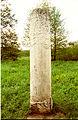
Copy of a Roman milestone, set up near where it was found on the Steinrütsch

Part of the drainage pipeline to the Brunnenstube am Grünen Pütz has been developed for tourism

The well room at Grünen Pütz
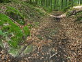
Serpentine of the Roman road Trier – Cologne in the slope of the Urft valley near Nettersheim above the Grüner Pütz

The Roman road Trier – Cologne near Nettersheim is clearly recognizable in the digital terrain model.


Francs
Franconian grave fields in the municipality are evidence of the Franconian period. In the district of Nettersheim there is a Franconian burial ground in the area of the “Auf der Kaulen” corridor.
So far, however, no early medieval settlement remains have been discovered in the community of Nettersheim.
Castles
There were three known castles in the village of Nettersheim:
- Apart from two hills in the area, almost nothing can be seen of the Alteburg .
- The castle Nettersheim near the mouth of the Geneva Bach in the Urft was completely demolished in the 19th century.
- The castle house of the younger castle , which is also called Dietrichsburg, is still preserved today.
time of the nationalsocialism
Some ground monuments also date from the time of National Socialism: In the Zingsheim district , remains of bunkers and flak positions can still be seen on the Willenberg and Ottenberg (see German base map on a scale of 1: 5000).
Between the places Tondorf and Falkenberg there are still the remains of two launch bases of the V1 . This firing position was put into operation in November 1944, but could no longer fire a V1 due to damage that occurred on November 29, 1944.
History of the place Nettersheim
Roman time
Already in Roman times there were settlements in the district and the municipality of Nettersheim. As already mentioned in the section “Archeology”, this is proven by many archaeological monuments. The most impressive and largest settlement from this period in the municipality is the Roman vicus, which stretched from Görresburg to Steinrütsch and was probably called Marcomagus .
middle Ages
Probably Nettersheim was first mentioned in 867 as "nefresheim" in a document from King Lothar II . Then the place is mentioned again in the year 893 as “nettersheym” in the property register of the Prüm Abbey .
In Nettersheim, too, ownership was determined by the manor in the Middle Ages. The most important Nettersheimer family were the knights of Nechtersheim. Their moated castle is still shown on the Tranchot map and was located near the mouth of the Geneva stream in the Urft. With the construction of the railway in the 19th century, the remains of the castle disappeared for good, and its foundations are now under the railway line and the parking lot east of the railway.
19th century

During the French occupation of the Rhineland after 1794, the place Nettersheim belonged to the canton Blankenheim in the Département de la Sarre .
The 19th century in the Eifel was often marked by hardship and hunger. In addition, a large part of the village burned down on December 19 and 20, 1862, caused by arson.
In 1870 the town of Nettersheim became a railway station when rail traffic was released.
In 1894, the landowner and owner of the Heinrich-Sophia-Burg Meller estate in Nettersheim opened a Kneipp spa, which was only operated for a few years. At that time the name “Bad Nettersheim” was used for advertising, from 1902 only the name “Luftkurort Nettersheim” was used. The Meller family had already acquired the ruins of the Nettersheimer Wasserburg in 1850 , had them blown up in 1857 and built the Heinrich-Sophia-Burg estate with the building material obtained .
Contemporary history
In 1920 the construction of the Sacred Heart Monastery ( 50 ° 29 ′ 42 ″ N , 6 ° 38 ′ 4 ″ E ) , which had been commissioned by the Order of the Cellites , was completed. The monastery was also used for recreation for children from the city, disabled people and survivors of the war. The buildings are the work of the Cologne architect Thomas Klee .
Incorporations
On July 1, 1969, the previously independent communities of Bouderath, Buir, Engelgau, Frohngau, Holzmülheim, Marmagen, Pesch, Roderath, Tondorf and Zingsheim were incorporated.
politics
The municipal administration is located in the Zingsheim district .
Municipal council
In the local elections on May 25, 2014, the following distribution of seats in the local council resulted for the 2014–2020 period.
mayor
Wilfried Pracht was first elected mayor in 2004 as the only candidate. In 2009 he was re-elected with 82.7 percent and in 2015 with 82.1 percent of the vote, each with no opponent.
Parish partnership
The partner municipality is the Belgian municipality of Zutendaal in the Flanders region .
badges and flags
coat of arms

rectangular flag

banner

square flag


The municipality was granted the right to use a coat of arms, a seal and a flag in a certificate from the district president dated August 12, 1974.
| coat of arms | |
| Blazon : “Half split and divided by gold (yellow), silver (white) and blue; in front above in gold (yellow) a red-armored and tongued black lion, behind in silver (white) a continuous black bar cross; below in blue six (3: 2: 1) silver (white) sea leaves. " | |
| Justification of the coat of arms: According to § 2 of the main statute of the community, the municipal coat of arms consists of three components. The lion comes from the coat of arms of the Duchy of Jülich and the black bar cross from Kurköln , the six silver sea leaves on a blue background were the coat of arms of the Knights of Nechtersheim. |
- flag
The municipal flag, which was approved by the district director on August 12, 1974, has the colors "blue and white" according to the main statute and shows the municipal coat of arms.
The hoist flag is either a square or rectangular cloth (aspect ratio 5: 3, heraldic shield on the third division line), the banner as a vertically rectangular cloth (aspect ratio 3: 5).
Myths and legends
In the stories from the villages of the municipality of Nettersheim, the church towers of Zingsheim and Tondorf and the Ahe chapel are traced back to Roman watchtowers. According to stories, the churches of Bouderath, Frohngau and Tondorf are supposed to stand on the site of former pagan places of worship. The pagan temple in Pesch, which dates back to Roman times, and the Roman canal , which begins at Grüner Pütz and is known as the devil's work with “Düwelsoder”, is also the subject of legends.
Further topics of legends from the community are underground passages and watercourses, dwarfs, wayside crosses and the Knights Templar . Fairies, called Juffern , also play a role in the stories of the community of Nettersheim.
One of the most impressive legends from the village of Nettersheim is that of the "miracle on the Eschepütz". When the bones of St. Potentinus and his sons Felicius and Simplitius were transferred from Karden to Steinfeld in the tenth century , the procession is said to have stopped in Nettersheim. People gathered, including a pagan man. He demanded a source as proof of faith, which should also have arisen immediately through a divine miracle. This spring is said to have been given the name "Potentinus-Brunnen" or "Eschepütz".
Economy and Infrastructure
Above all, the relatively fertile areas of the Sötenicher and Blankenheimer Kalkmulde serve agriculture as arable land and grassland. Large parts of the remaining municipal area are used for forestry.
With the Rhineland Wood Competence Center, the municipality is a partner of the European Wood Route .
There is an industrial park in the south of Zingsheim . The Eifelhöhen Clinic in Marmagen is also an important employer .
traffic


The Nettersheim train station is centrally located on the Eifelbahn ( Cologne - Euskirchen - Gerolstein - Trier ). Drive it:
| line | Line course | Tact |
|---|---|---|
| RE 22 |
Eifel-Express : Cologne Messe / Deutz - Cologne Central Station - Cologne West - Cologne South - Erftstadt - Weilerswist - Euskirchen - Mechernich - Kall - Urft (Steinfeld) - Nettersheim - Blankenheim (Wald) - Schmidtheim - Dahlem (Eifel) - Jünkerath - Lissendorf - Oberbettingen - Hillesheim - Gerolstein Status: timetable change December 2016 |
60 min |
| RB 24 |
Eifel Railway : Cologne Messe / Deutz - Cologne Central Station - Cologne West - Cologne South - Hürth-Kalscheuren - Brühl-Kierberg - Erftstadt - Weilerswist - Weilerswist-Derkum - Euskirchen-Großbüllesheim - Euskirchen - Satzvey - Mechernich - Scheven - Kall Status: timetable change December 2016 |
60 min |
The rail transport is by the DB Regio NRW performed, the diesel railcar type Alstom Coradia LINT for speeds using h to km to 120 /.
In the course of rationalization measures, the mechanical signal box was closed on March 26, 2010 and connected to the electronic signal box (EStw) in Gerolstein, which was built in January 2006. Since then, Nettersheim station has no longer been manned by railway personnel.
There are bus connections to Bad Münstereifel, Marmagen and Buir.
The regional tariff of the Verkehrsverbund Rhein-Sieg (VRS) and the NRW tariff apply to all local public transport .

The federal motorway 1 runs through the municipality with the junctions Nettersheim (113) and Blankenheim (114) near the district of Tondorf . At Zingsheim , the A1 runs over the 820 m long Zingsheimer Wald viaduct .
In the neighboring district of Dahlem is located about 12 km of the airfield Dahlem Binz .
tourism
Nettersheim is known for gentle nature and hiking tourism as well as extensive running or cycling tours. Worth seeing in the village of Nettersheim are the Eifel nature center and the agricultural museum courtyard at Bahnhofstrasse 7, where the history of the development of agriculture from purely handcraft to modern combine harvesters can be experienced and recorded through many objects, but also through series of pictures. The Mannenberg Caves are nearby .
In addition to hotels, guest houses, holiday homes and apartments, there are also accommodations for groups and school classes:
- Especially for groups and school classes, Nettersheim offers inexpensive accommodation in a youth hostel, on a youth tent site and in a self-catering house.
- A motorhome parking space is available for motorhome travelers .
In addition to hiking trails on specific topics such as geology, archeology or nature around Nettersheim, longer routes also lead through Nettersheim:
- The Römerkanal hiking trail along the Eifel aqueduct to Cologne, which was renewed in 2012, begins in Nettersheim .
- The Eifelsteig , a hiking trail from Aachen to Trier , also leads from Steinfeld past the Green Pütz to Nettersheim and then on to Blankenheim .
The long-distance cycle paths lead through the village:
- Eifel-Höhen-Route , which runs as a circular route around and through the Eifel National Park .
- Valley route , it opens up interesting tourist places in North Rhine-Westphalia on a family-friendly route.
Telephone prefixes
Nettersheim has the area code 02486. In contrast, the area code 02253 applies in Bouderath, the 02440 in Buir, Frohngau and Tondorf and the 02484 in Pesch.
literature
- Eifelverein (ed.): Nettersheim community with the towns of Bouderath, Buir, Engelgau, Frohngau, Holzmülheim, Marmagen, Nettersheim, Pesch, Roderath, Tondorf, Zingsheim. History, geology, flora and fauna, economy, legends, sights, hiking suggestions (= series of publications: "The beautiful Eifel". Nettersheim edition ). 1st edition. 1984, ISSN 0342-5819 .
- Municipality of Nettersheim (ed.): That's how it was in Nettersheim. Meinerzhagener Druck- und Verlagshaus, Meinerzhagen 1983, ISBN 3-88913-070-4 . (Collection of historical photographs from the community)
- Klaus Grewe : Atlas of the Roman water pipes to Cologne (= Rhenish excavations. Volume 26). With contributions by Werner Brinker, Günther Garbrecht, Hansgerd Hellenkemper , Heinz-Otto Lamprecht, Horst D. Schulz , Edgar Thofern. Rheinland-Verlag, Cologne 1986, ISBN 3-7927-0868-X , p. 38 ff.
- Klaus Grewe, Manfred Knauff: The long leadership of the Romans. The Römerkanal hiking trail Nettersheim-Cologne. Publisher: Eifelverein eV 1st edition 2012. ISBN 978-3-921805-81-7 .
- Mariola Hepa, Michelle Forrest and Salvatore Ortisi : New investigations in the vicus of Nettersheim. In: Jürgen Kunow (Hrsg.): Archeology in the Rhineland 2009. A publication of the LVR office for soil monument preservation in the Rhineland. Konrad Theiss Verlag, Stuttgart 2010, ISBN 978-3-8062-2383-5 , p. 89 ff.
- Heinz Günter Horn : Agrippastraße Cologne-Trier. Section Nettersheim. Of serpentines, temples and guard stations. 1st edition. JP Bachem Verlag, Cologne 2011, ISBN 978-3-7616-2365-7 .
- Heinz Günter Horn (Ed.): The Romans in North Rhine-Westphalia . Konrad Theiss Verlag, Stuttgart 1987, ISBN 3-8062-0312-1 , pp. 571-580.
- Rita Hupp-Schneider: With nailed shoes ... childhood in the country. A picture and text documentation from the community of Nettersheim with the places Bouderath, Buir, Engelgau, Frohngau, Holzmülheim, Marmagen, Nettersheim, Pesch, Roderath, Tondorf, Zingsheim. 1850-1950. Published by the community of Nettersheim. Hahne & Schloemer Verlag, 1989, ISBN 3-927312-03-7 .
- Ursula Ibler, Ruth Plum, Imke Ristow: Archeology in Nettersheim . Eifel nature conservation center. Guide through the archaeological exhibition in the Eifel nature conservation center and presentation of the archaeological monuments. Publisher: Nettersheim community. 1998.
- Walter Janssen : Studies on the desert issue in the Franconian old settlements between the Rhine, Moselle and the north edge of the Eifel. Part II: Catalog (= Landschaftsverband Rheinland, Rheinisches Landesmuseum Bonn and Association of Friends of Antiquity in the Rhineland [Hrsg.]: Supplements to the Bonner Jahrbücher. Volume 35, Part II). Rheinland-Verlag u. a., Cologne 1975, p. 439 ff.
- Antonius Jürgens: Practical ground monument maintenance: excavations and restorations of archaeological monuments in the community of Nettersheim. In: District Euskirchen (Hrsg.): Yearbook of the District Euskirchen 1978. P. 125 ff.
- GU Knackstedt: Neanderthals, Romans, Franks. Settlement history of the district of Euskirchen based on archaeological finds. 1991.
- Gerd-Uwe Knackstedt: Two new old finds from Nettersheim In: Jürgen Kunow (Ed.): Archeology in the Rhineland 1989. Rhineland Regional Association, Rheinisches Amt für Bodendenkmalpflege. Rheinland-Verlag, Cologne 1990, p. 38ff.
- Sophie Lange: The “Wörishofen of the Eifel” and its slow end. In 1894 Kneipp'sche Kuranstalt was established in "Bad" Nettersheim. In: District Euskirchen (Hrsg.): Yearbook of the District Euskirchen 1995. P. 5–12.
- Sophie Lange: It's haunted here. Legends and old village stories from the eleven places in the municipality of Nettersheim. Collected and edited by Sophie Lange. Nettersheim 2000.
- Sophie Lange: Where goddesses protected the land - matrons and their places of worship between the Eifel and the Rhine . 2nd Edition. Fuldaer Verlagsanstalt, Fulda 1995, ISBN 3-9802165-4-3 ( online in sophie-lange.de ).
- Salvatore Ortisi, Imke Ristow: Nettersheim: vicus with matron shrine. In: Vera Rupp and Heide Birley (Hrsg.): Country life in Roman Germany. Konrad Theiss Verlag, Stuttgart 2012, ISBN 978-3-8062-2573-0 , p. 105 ff.
- Nikola Reinartz : The Krummel von Nechtersheim, an Eifel knight family. In: Annals of the Historical Association for the Lower Rhine, in particular the old Archdiocese of Cologne. Issue 139, published by L. Schwann, Düsseldorf 1941, pp. 1-72.
- Imke Ristow: The Sacred Heart Monastery in Nettersheim. In: Rheinische Heimatpflege . Announcements from the Rhenish Association for Monument Preservation and Landscape Protection eV (special print) . 37th Volume No. 2, 2000, ISSN 0342-1805 , p. 111 ff .
- Hans Peter Schiffer: The Urft Valley in the Eifel. Landscape, nature, history. 2nd Edition. LandpresseRegio, Weilerswist 2006.
- Hans Peter Schiffer: Churches and chapels in the parish of Nettersheim. History, design, equipment. Kall 2004.
- Friedrich Jakob Schruff: The great fire of Nettersheim. In: 1966 local calendar of the Schleiden district. P. 84 f.
- W. Schumacher, F.-J. Outside with the participation of G. Scheibe: Landscape and flora in the community of Nettersheim. Publisher: Nettersheim community. no year
- Association of Nettersheim (ed.): Our village of Nettersheim, 1100 years and more. no year
- Ernst Wackenroder : The art monuments of the Schleiden district. (= Paul Clemen [Hrsg.]: Die Kunstdenkmäler der Rheinprovinz , Volume 11, Section II). Published by L. Schwann, Düsseldorf 1932.
Web links
- Website of the community of Nettersheim. Nettersheim community, accessed on May 11, 2017 .
- North Eifel Nature Park. Naturpark Nordeifel eV, accessed on May 11, 2017 .
- European wooden route. Nettersheim community, accessed on May 11, 2017 .
- Roman buildings in Nettersheim and Mechernich. Retrieved May 11, 2017 .
Individual evidence
- ↑ Population of the municipalities of North Rhine-Westphalia on December 31, 2019 - update of the population based on the census of May 9, 2011. State Office for Information and Technology North Rhine-Westphalia (IT.NRW), accessed on June 17, 2020 . ( Help on this )
- ↑ Law on the reorganization of municipalities in the Schleiden district of June 24, 1969
- ^ A b Hans Peter Schiffer: Churches and chapels in the community of Nettersheim. 2004, p. 105.
- ^ A b Hans Peter Schiffer: Churches and chapels in the community of Nettersheim. 2004, p. 106.
- ^ A b Hans Peter Schiffer: Churches and chapels in the community of Nettersheim. 2004, p. 107.
- ^ Mint never hinged - Das Philatelie-Journal, January / February 2012
- ↑ a b c d e f g h Topographical Information Management, Cologne District Government, Department GEObasis NRW ( information )
- ^ Karl-Heinz Ribbert: Geology. In: Eifelverein (ed.): Nettersheim community with the towns of Bouderath, Buir, Engelgau, Frohngau, Holzmülheim, Marmagen, Nettersheim, Pesch, Roderath, Tondorf, Zingsheim. History, geology, flora and fauna, economy, legends, sights, hiking suggestions. 1984, p. 80 ff.
- ↑ W. Schumacher, F.-J. Outside with the participation of G. Scheibe: Landscape and flora in the community of Nettersheim. no year, p. 3 f.
- ↑ Wolfgang Schumacher: Nature and landscape in the community of Nettersheim. In: Eifelverein (ed.): Nettersheim community with the towns of Bouderath, Buir, Engelgau, Frohngau, Holzmülheim, Marmagen, Nettersheim, Pesch, Roderath, Tondorf, Zingsheim. History, geology, flora and fauna, economy, legends, sights, hiking suggestions. 1984, p. 80 ff.
- ^ Antonius Jürgens: Practical soil monument maintenance: excavations and restorations of archaeological monuments in the community of Nettersheim. In: District Euskirchen (Hrsg.): Yearbook of the District Euskirchen 1978. P. 125 ff.
- ↑ Gerd-Uwe Knackstedt: excavations of a Roman estate near Roderath, Nettersheim community. In: Eifelverein (Ed.): Eifeljahrbuch 1987. S. 152.
- ^ Hans-Eckart Joachim, Wighart v. Koenigswald, Wilhelm Meyer: Kartstein and Katzensteine near Mechernich in the Eifel (= Rheinischer Verein für Denkmalpflege und Landschaftsschutz [Hrsg.]: Rheinische Kunststätten, No. 435). 1st edition 1998. Printing and commission publisher: Neusser Druckerei und Verlag GmbH, Neuss, p. 21 f.
- ^ Gerd-Uwe Knackstedt: Two new old finds from Nettersheim. In: Jürgen Kunow (Hrsg.): Archäologie im Rheinland 1989. 1990, p. 38 ff.
- ↑ SK Arora: Fund Directory . In: Bonner Jahrbücher 1996 .
- ^ Antonius Juergens and Marianne Juergens: Prehistory and early history. Stone Ages, Metal Ages, Romans, Franks. In: Eifelverein (Ed.): Nettersheim community with the towns of Bouderath, Buir, Engelgau, Frohngau, Holzmülheim, Marmagen, Nettersheim, Pesch, Roderath, Tondorf, Zingsheim. 1984, p. 42.
- ^ Klaus Grewe: Atlas of the Roman water pipes to Cologne . With contributions by Werner Brinker, Günther Garbrecht, Hansgerd Hellenkemper, Heinz-Otto Lamprecht, Horst D. Schulz, Edgar Thofern. Rheinland Verlag, Cologne 1986, p. 38 ff.
- ^ Mariola Hepa, Michelle Forrest and Savatore Ortisi: New investigations in the vicus of Nettersheim. In: Jürgen Kunow (Ed.): Archeology in the Rhineland 2009. 2010, p. 91.
- ^ A b Mariola Hepa, Michelle Forrest and Salvatore Ortisi: New investigations in the vicus of Nettersheim. In: Jürgen Kunow (Ed.): Archeology in the Rhineland 2009. 2010, p. 89 ff.
- ^ Salvatore Ortisi and Imke Ristow: Nettersheim: vicus with matron sanctuary. In: Vera Rupp and Heide Birley (Hrsg.): Country life in Roman Germany. 2012, p. 105 ff.
- ^ Heinz Günter Horn: Nettersheim: Roman temple district. In: Heinz Günter Horn (Ed.): The Romans in North Rhine-Westphalia . 1987, p. 571 ff.
- ^ Heinz Günter Horn: The matron shrine near Nettersheim. In: Northeastern Eifel foreland - Euskirchen, Zülpich, Bad Münstereifel, Blankenheim. Part II: Excursions (= Römisch-Germanisches Zentralmuseum Mainz et al. [Hrsg.]: Guide to prehistoric and early historical monuments, volume 26). Verlag Philipp von Zabern, Mainz am Rhein 1974, p. 88 ff.
- ^ Sophie Lange: Where goddesses protected the land. Matrones and their places of worship between the Eifel and the Rhine. 1995, pp. 63-91.
- ^ Salvatore Ortisi and Imke Ristow: Nettersheim: vicus with matron sanctuary. In: Vera Rupp and Heide Birley (Hrsg.): Country life in Roman Germany. 2012, p. 106 f.
- ↑ a b c d Rainer Laskowski: Nettersheim: Römische Ackerterrassen. In: Heinz Günter Horn (Ed.): The Romans in North Rhine-Westphalia. 1987, p. 575 f.
- ^ Walter Janssen: Studies on the desert question in the Franconian old settlements between the Rhine, Moselle and Eifelnordrand. Part II: Catalog. 1975, p. 453 ff.
- ^ Heinz Günter Horn: Agrippastraße Cologne-Trier. Section Nettersheim. Of serpentines, temples and guard stations. 2011.
- ↑ Cornelius Ulbert, Katrin Lang-Novikov and Ursula Ulrich-Wick: Römerstraße experience space: Agrippa-Straße - investigations in the Eifel . In: Jürgen Kunow (Hrsg.): Archeology in the Rhineland 2009. A publication of the LVR office for soil monument preservation in the Rhineland. Konrad Theiss Verlag, Stuttgart 2010, p. 96 f.
- ↑ Cornelius Ulbert, Katrin Lang-Novikov and Ursula Ulrich-Wick: Römerstraße experience space: Agrippa-Straße - investigations in the Eifel . In: Archeology in the Rhineland 2009 . Published by Jürgen Kunow. A publication of the LVR office for soil monument preservation in the Rhineland. Stuttgart: Konrad Theiss Verlag, 2010. P. 98.
- ↑ a b Klaus Grewe: Two Roman roads south of the Urft. In: Harald Koschik (Ed.): Archeology in the Rhineland 2001 . Konrad Theiss Verlag, Stuttgart 2010, p. 64.
- ↑ Klaus Grewe: Two Roman roads south of the Urft. In: Harald Koschik (Ed.): Archeology in the Rhineland 2001 . Konrad Theiss Verlag, Stuttgart 2010, p. 63 f.
- ^ Heinz Günter Horn: Agrippastraße Cologne-Trier. Section Nettersheim. Of serpentines, temples and guard stations. 2011, p. 54 ff.
- ^ Heinz Günter Horn: Nettersheim-Roderath: Römischer Gutshof . In: Heinz Günter Horn (Ed.): The Romans in North Rhine-Westphalia . 1987, p. 578 f.
- ^ Heinz Günter Horn: Agrippastraße Cologne – Trier. Section Nettersheim. Of serpentines, temples and guard stations. 2011, p. 42 f.
- ^ Rainer Laskowski: Nettersheim: Römisches Pingenfeld. In: Heinz Günter Horn (Ed.): The Romans in North Rhine-Westphalia. 1987, p. 576 f.
- ^ Rainer Laskowski: Nettersheim: Römisches Pingenfeld. In: Heinz Günter Horn (Ed.): The Romans in North Rhine-Westphalia. 1987, p. 577.
- ^ Heinz Günter Horn: Bad Münstereifel-Nöthen: Roman temple district. In: Heinz Günter Horn (Ed.): The Romans in North Rhine-Westphalia . 1987, p. 342 ff.
- ^ A b Heinz Günter Horn: Nettersheim-Zingsheim: Gallo-Roman temple . In: Heinz Günter Horn (Ed.): The Romans in North Rhine-Westphalia . 1987, p. 579 f.
- ↑ Ursula Ibler, Ruth Plum, Imke Ristow: Archeology in Nettersheim . 1998, p. 36 ff.
- ^ Antonius Juergens and Marianne Juergens: Prehistory and early history. Stone Ages, Metal Ages, Romans, Franks. In: Eifelverein (Ed.): Nettersheim community with the towns of Bouderath, Buir, Engelgau, Frohngau, Holzmülheim, Marmagen, Nettersheim, Pesch, Roderath, Tondorf, Zingsheim. 1984, p. 70 ff.
- ↑ GU Knackstedt: Neanderthals, Römer, Franconia. Settlement history of the district of Euskirchen based on archaeological finds. 1991, p. 82.
- ↑ Ursula Ibler, Ruth Plum, Imke Ristow: Archeology in Nettersheim. 1998, p. 36.
- ↑ Harald Herzog: Castles and Palaces. History and typology of the aristocratic seats in the Euskirchen district (= A-series. Volume 17). Rheinland-Verlag, Cologne 1989, ISBN 3-7927-1067-6 , p. 401.
- ↑ a b Harald Herzog: Castles and palaces. History and typology of the aristocratic seats in the Euskirchen district (= A-series. Volume 17). Rheinland-Verlag, Cologne 1989, p. 401 f.
- ↑ Harald Herzog: Castles and Palaces. History and typology of the aristocratic seats in the Euskirchen district (= A-series. Volume 17). Rheinland-Verlag, Cologne 1989, p. 402 ff.
- ↑ Alexander Kuffner: Time Travel Guide Eifel 1933-1945. 2nd edition July 2007. Helios-Verlag, Aachen, p. 105 f.
- ↑ Wolfgang Gückelhorn, Detlev Paul: V1 - "Eifelschreck". Kills, crashes and impacts of the flying bomb from the Eifel and the right bank of the Rhine in 1944/45. Documentation. Helios-Verlag, Aachen 2004, p. 93.
- ^ Antonius Juergens and Marianne Juergens: Prehistory and early history. Stone Ages - Metal Ages - Roman Franks. In: Eifelverein (Ed.): Nettersheim community with the towns of Bouderath, Buir, Engelgau, Frohngau, Holzmülheim, Marmagen, Nettersheim, Pesch, Roderath, Tondorf, Zingsheim. 1984, p. 45.
- ^ Sophie Lange: Nettersheim. The village and its history. In: Vereingemeinschaft Nettersheim (Ed.): Our village Nettersheim, 1100 years and more. no year, p. 17.
- ^ Heinrich Beyer : Document book for the history of the Middle Rhine territories, now the Prussian administrative districts of Coblenz and Trier. Edited from the sources by Heinrich Beyer. First volume: From the oldest times to the year 1169. Hölscher, Coblenz 1860, p. 113 .
- ^ Heinrich Beyer: Document book for the history of the Middle Rhine territories, now the Prussian administrative districts of Coblenz and Trier. Edited from the sources by Heinrich Beyer. First volume: From the oldest times up to the year 1169. Hölscher, Coblenz 1860, p. 177.
- ↑ Nikola Reinartz: The Krummel von Nechtersheim, an Eifel knight family. In: Annals of the Historical Association for the Lower Rhine. 1941, pp. 1-72.
- ^ Sophie Lange: Nettersheim. The village and its history. In: Vereingemeinschaft Nettersheim (Ed.): Our village Nettersheim, 1100 years and more. no year, p. 27.
- ↑ Friedrich Jakob Schruff: The great fire of Nettersheim. In: 1966 local calendar of the Schleiden district. P. 84 f.
- ^ Sophie Lange: The "Wörishofen der Eifel" and its slow end. In: District Euskirchen (Hrsg.): Yearbook of the District Euskirchen 1995. P. 5–12.
- ^ Sophie Lange: The "Wörishofen der Eifel" and its slow end. In: District Euskirchen (Hrsg.): Yearbook of the District Euskirchen 1995. P. 12.
- ^ Sophie Lange: The "Wörishofen der Eifel" and its slow end. In: District Euskirchen (Hrsg.): Yearbook of the District Euskirchen 1995. S. 5.
- ↑ Imke Ristow: The Herz-Jesu-Kloster in Nettersheim . Reprint from: Rheinische Heimatpflege. 2000, p. 112.
- ^ A b Hans Peter Schiffer: Churches and chapels in the community of Nettersheim. 2004, p. 116.
- ↑ Martin Bünermann: The communities of the first reorganization program in North Rhine-Westphalia . Deutscher Gemeindeverlag, Cologne 1970, p. 101 .
- ^ Parish of Nettersheim. Overall result. May 25, 2014, accessed October 14, 2014 .
- ↑ Main statute of the municipality of Nettersheim, § 2. (PDF; 736 kB) Accessed on January 21, 2016 .
- ↑ Hans Peter Schiffer: The Urft valley in the Eifel. Landscape, nature, history. 2006, p. 73.
- ↑ Nettersheim flag on www.kommunalflaggen.de. Retrieved January 2, 2013 .
- ↑ Sophie Lange (Ed.): It's haunted here. Legends and old village stories from the eleven places in the municipality of Nettersheim. 2000, p. 12.
- ↑ Sophie Lange (Ed.): It's haunted here. Legends and old village stories from the eleven places in the municipality of Nettersheim. 2000, p. 13.
- ↑ Sophie Lange (Ed.): It's haunted here. Legends and old village stories from the eleven places in the municipality of Nettersheim. 2000, pp. 13 and 89 ff.
- ↑ Sophie Lange (Ed.): It's haunted here. Legends and old village stories from the eleven places in the municipality of Nettersheim. 2000, p. 13 ff.
- ↑ Rita Hupp-Schneider: With nailed shoes ... childhood in the country. 1989, p. 139.
- ↑ Sophie Lange (Ed.): It's haunted here. Legends and old village stories from the eleven places in the municipality of Nettersheim. 2000, p. 89 ff.
- ↑ Klaus Grewe, Manfred Knauff: The long leadership of the Romans. The Römerkanal hiking trail Nettersheim-Cologne. 2012, pp. 40 ff, 148 ff.
Bad Münstereifel | Blankenheim | Dahlem | Euskirchen | Hellenthal | Kall | Mechernich | Nettersheim | Schleiden | Weilerswist | Zülpich