
Valley route
| Valley route | |
|---|---|
|
|
|
| overall length | approx. 265 km (cycle path network) |
| location | Eifel / North Rhine-Westphalia , Euskirchen district |
| map | |
| Link on map | |
| Places along the way | Blankenheim , Nettersheim , Kall , Mechernich , Euskirchen , Rurberg , Gemünd , Hellenthal , Kall , Bad Münstereifel , Zülpich |
| Traffic volume | Mainly cycle paths and farm roads, some smaller roads |
| Connection to | Erft-Radweg , Ahr-Radweg , RurUfer-Radweg , Eifel-Höhen-Route , Wasserburgroute , Kaiser-Route , Kylltal-Radweg |
| Website URL | Homepage of the valley routes |
The valley route is a cycling route that connects tourist destinations in the Euskirchen district of Euskirchen with family-friendly routes on a network of approx. 265 kilometers of cycle paths . The northern Eifel can be explored along streams and rivers, through romantic stream valleys, picturesque villages, imposing castles and palaces. Due to the proximity to the Cologne - Trier and Euskirchen - Bad Münstereifel railway lines, individual entry into the valley route is possible almost everywhere. The valley routes project was brought into being by the Agenda 21 measure "Bicycle-friendly district" Euskirchen. The concept is essentially based on three pillars:
- Creation of a tourist bicycle route sign
- Closing of network gaps between route sections
- Tourist information systems
Characteristic
On the valley routes there are possible combinations between the individual bike routes. From high-altitude train stations such as Schmidtheim , Nettersheim and Blankenheim-Wald , valley routes can be undertaken without any significant inclines. The entry points in the routes are chosen so that they can be reached by train or bus. It is also possible to park the car at many destination points and return to the entry point by public transport. The routes are signposted in both directions with the bike path logo. Along the rivers it bears the river name as additional information.
The valley routes are divided into two groups.
1. River cycle paths
Cycle paths that run along the rivers with little incline:
Erft cycle path (approx. 55 km in the district of Euskirchen)
This cycle path was launched by the Rhine district of Neuss , the Rhein-Erft district and the district of Euskirchen. Approx. 110 km along the Erft from the source in Holzmülheim to the confluence with the Rhine near Neuss-Gnadental can be comfortably cycled.
Ahr cycle path (approx. 20 km in the district of Euskirchen)
This cycle path represents a continuous connection between the source in Blankenheim and the confluence with the Rhine at Sinzig. This approx. 80 km long cycle path runs mostly near the river.
Urft cycle path (approx. 40 km)
This cycle path starts at the train station in Blankenheim-Wald and, apart from a few small climbs, leads steadily downwards to the RurUfer cycle path near Rurberg . From the Blankenheim forest the route leads together with the Eifel-Höhen-Route via Nettersheim to Urft . From here it follows the Urft valley to Kall where it meets the alternative route of the Eifel-Höhen-Route and leads with it on the section called "Urftseeroute" through the former military training area Vogelsang in the Eifel National Park to Rurberg. There are approx. 145 vertical meters of climbs to be mastered along the entire route .
Olef cycle path (approx. 25.5 km)
This tour starts on the Eifel-Höhen-Route at the fire watchtower near Wahlerscheid (Monschau car park XIX). With the Eifel-Höhen-Route it leads together to the Olef reservoir and to Hellenthal . From here it follows the Olef to the confluence of the Urft in Gemünd . This is where the connection to the Urft cycle path takes place. There are approx. 85 vertical meters of climbs to be mastered along the entire route.
Bleibach cycle path (approx. 9 km with an increase in altitude of approx. 22 meters)
This cycle path runs between Obergartzem and Mechernich . It leads along the Bleibach, a tributary of the Rotbach , and crosses the timber-framed village of Kommern .
Veybach cycle path (approx. 16 km; approx. 180 vertical meters ascending)
The cycle path begins on the Erft cycle path in Euskirchen and leads via Satzvey to Mechernich. It largely follows the Veybach , which flows into the Erft in Euskirchen and rises near Mechernich. The route meets the Bleibach cycle path in Obergartzem, but then follows the Vaybach further south via Satzvey with its castle and leads past Kommern-Süd to Mechernich.
Rotbach cycle path (approx. 25 approx. 108 vertical meters ascent)
From Kommern, the route leads near the Rotbach via Eicks , Schwerfen and Nemmenich towards Friesheim . (For details see #Tour 4: "Magnificent street of palaces and castles" ). Apart from a few small climbs (around 20 meters in altitude), the route is sloping to flat.
Neffelbach cycle path (approx. 10 km in the Euskirchen district)
This route only runs on a small section in the Euskirchen district between Bessenich and Juntersdorf . The majority is located in the Rhein-Erft district and in the Düren district. On a total distance of approx. 52.5 km it connects the RurUfer cycle path in Heimbach with the Erft behind Mödrath .
2. Connection routes
Cycle paths link the various routes with each other and thus create a closed network:
Ahr-Erft connection
a) Schuld - Schönau approx. 13 km
b) Blankenheim - Holzmülheim approx. 10.5 km
Erft-Urft-Ahr connection
Blankenheim - Blankenheim-Wald approx. 5.5 km
Erft-Urft connection
Nettersheim - Holzmülheim approx. 8.5 km
Bleibach-Veybach connection
Mechernich approx. 2 km
Kyll-Erft connection
a) Blankenheim-Wald - Glaadt approx. 14 km
b) Blankenheim-Wald - Kronenburgerhütte approx. 16 km
Neffelbach-Rotbach connection
Lövenich - Zülpich approx. 4.5 km
Tour flyer for the routes
The Euskirchen district has put together four possible routes in flyers that can be accessed on the valley route website.
Tour 1: "Route of Versatility"
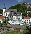
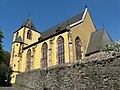
Parish Church and Blankenheim Castle

Ahrquelle in Blankenheim

Basilica of the Steinfeld Monastery
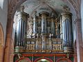
König organ in the basilica of the Steinfeld monastery

Mill in the LVR open-air museum in Kommern

Center of Kommern
.jpg)

,_Freilichtmuseum_Kommern,_1978.jpg)

It starts at the Blankenheim-Wald train station, and it first goes downhill along the Urft via Nettersheim to Kall . There the short ascent of around 30 meters up to Wallenthaler Höhe has to be mastered. Then it goes without major climbs through fields past Wallenthal, Schützendorf and hostel to Kommern. The historic town center or the LVR open-air museum can be visited here. The last 14 kilometers of this tour then lead through Schaven , Obergartzem , Wißkirchen and Euenheim to Euskirchen.
The route is approx. 45 km long and a total of approx. 233 meters in altitude has to be mastered. Because of some dirt roads in the Urft valley, the route is not well suited for racing bikes.
The following sights are passed on the route:
- From Blankenheim-Wald you can take a detour to Blankenheim on another stretch of the valley route. Up to there are approx. 6 km and approx. 80 meters in altitude to master. Blankenheim with its historic town center offers half-timbered buildings in romantic corners and alleys. The Ahr spring is located here in the cellar of a half-timbered house, remains of the former city fortifications with the Georgstor from 1670 and the shepherd's tower from 1404, as well as the late Gothic parish church of St. Mary's Assumption, which was completed in 1505. Above the village is Blankenheim Castle from the 12th century, which now houses a youth hostel. In the Eifelmuseum Blankenheim, the regional museum for natural history and cultural history, there are permanent and changing exhibitions. The historical carnival museum in Georgstor impressively explains 400-year old Blankenheim carnival customs, in particular the Blankenheim ghost train.
- In Nettersheim, the Roman temple " Görresburg " and the Eifel nature center can be visited directly on the Urft.
- The former Premonstratensian Abbey of Steinfeld Monastery with its important basilica from the early 12th century is located near the village of Urft, a district of Kall, near the bike route . Located on a hill, visible from afar, the "Eifelkloster" forms the Steinfeld district with a few surrounding houses. A Roman Eifel aqueduct runs through Urft, which supplied Cologne with water from the Eifel in ancient times.
- Mechernich is home to the Landesmuseum für Volkskunde, the LVR open-air museum Kommern , in its district of Kommern , located about two kilometers to the north . With over 80 hectares it is one of the largest open-air museums in Europe and shows 65 historical buildings from the Prussian Rhine province. In addition, Kommern has the largest closed half-timbered ensemble in the Rhineland. In Mechernich there is also the mining museum and visitor mine Mechernicher lead pit , the prehistoric Kakushöhle .
- Veynau Castle is located in Obergartzem . The moated castle is one of the most impressive and at the same time most important medieval castle complex in the Rhineland. It still conveys the idea of a monumental Gothic knight's castle today. The castle, founded in 1340, has not been significantly changed in later years and is therefore an interesting object for research into medieval castles.
- Euskirchen's sights include the Old Market , the historical city fortifications, the Martinskirche and the city museum .
Tour 2: "Route of Historical Treasures"

Footbridge leading to the White Stone Rock
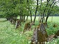
The cusp line of the west wall near Udenbreth
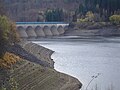
Oleftalsperre, lake side at low tide

Reifferscheid castle ruins
Schleiden Castle Church

Prelature of the Steinfeld Monastery


.jpg)
This bike tour suggestion leads almost exclusively downhill. The tour begins at the highest point in the Euskirchen district, on the 700 meter high "Weißer Stein" car park near Udenbreth. From there it follows the stream valleys of Preth, Olef and Urft over 32 kilometers with a steady gradient. This will take you to your destination, the train station in Kall. There are approx. 120 vertical meters of inclines to be mastered on the entire route.
The following sights are on the route:
- The White Stone is 693 m above sea level. NN high German-Belgian border mountain. The actual white stone is a 3 m long rock on Belgian territory.
- Remains of the former west wall along the route.
- In Hellenthal there is a game reserve with a bird of prey station, which offers flight demonstrations with eagles, buzzards and falcons from April to October. The Oleftalsperre is located below the game reserve . The construction of the dam in pillar cell construction is still unique in Germany today. It is also worth taking a detour from here to the castle village of Reifferscheid , about four kilometers away , a typical example of a Gothic castle valley settlement in the Eifel.
- The Castle Church Schleiden is a three-nave late Gothic church with power and stellar vault. It was built between 1516 and 1525 according to plans by Johann Vianden and is one of the most important late Gothic hall churches in the northern Eifel.
- The historic center of Olef with its closed, preserved village square with typical half-timbered houses, parish church and churchyard. The parish church of St. Johann Baptist or its west tower dates from the 13th century. The baptismal font made of Namur bluestone and the rare two-story altar are worth seeing .
- The Kneipp health resort Gemünd is the largest district of Schleiden , around 50% of which is part of the Eifel National Park . One of the five centers is located here, the so-called "National Park Gates", in which comprehensive information is provided about the National Park. The confluence of the Olef and Urft is also in Gemünd . The former NS-Ordensburg Vogelsang is located in the urban area of Schleiden .
- A wayside shrine from 1734 can be found in the municipality of Kall . The Madonna and Child in this wayside shrine is particularly venerated by the parish of St. Nicholas. The original of the Madonna and Child comes from the 14th century and is now in the parish church. The Primbsch Museum is located in the Kendenrich district. A private art museum that shows the works of painter EO Primbsch on a wide variety of painterly subjects such as landscapes and flowers as well as socially critical pictures. The former Premonstratensian Abbey of Steinfeld Monastery with its important basilica from the early 12th century is also located in the municipality near the bike route . Visible from afar, on a hill in the south of the municipality of Kall, the "Eifelkloster" forms the district of Steinfeld with a few surrounding houses.
- The Roman aqueduct near Kall ran directly through the municipality of Schleiden and Kall and is still visible in various places today. The historic line was built by the Romans to supply ancient Cologne .
Tour 3: "On tour with nature"

Ahekapelle in the Geneva valley

Bad Münstereifel, house from 1167

Bad Münstereifel, Red Town Hall

Tower and outer bailey of Kirspenich Castle

Euskirchen, old market

Kleinbüllesheim Castle


This cycle route leads from Nettersheim to Weilerswist. For the most part, it follows the course of the Erft cycle path . The flyer recommends arriving by train, because this route was chosen so that you can interrupt the tour at several points along the way and take the train back to the starting point. The route has a length of approx. 50 km and contains approx. 250 vertical meters of inclines. After the first ascent of around 80 meters in altitude for a good five kilometers, the route practically only leads downhill.
The following sights are on the route:
- The Eifel Nature Center invites you to visit Nettersheim . It offers exhibitions on nature, archeology, earth and cultural history of the Eifel.
- The Ahekapelle is located in the Genevabachtal nature reserve about three kilometers behind Nettersheim. The lonely Ahekapelle with a late Gothic choir originally belonged to a medieval settlement. In the nature reserve of the Geneva stream there is a rare lime swamp habitat in addition to limestone grasslands. As a result, rare orchids and grasses thrive here, e.g. B. orchids, marsh stendrums and cotton grass.
- The Erftquelle is located near the Holzmülheim district of Nettersheim . This is where the Erft cycle path begins, which the route follows to its end point in Weilerswist.
- Bad Münstereifel has an almost completely preserved, restored town wall with a historic town center. The Romanesque collegiate church of St. Chrysanthus and Daria , which began around 1100 , the Romanesque house from 1167, the Windeckhaus with its elaborate carved facade and the town hall are particularly inviting for a visit there. A Roman lime distillery can be visited in the Iversheim district . The castle Kirspenich located in the same district.
- Euskirchen is the first to be reached with its Stotzheim district , where Hardtburg is located . In the eastern district of Kuchenheim , which can be reached on an alternative route of the Erft cycle path, there is part of the Rhenish Industrial Museum , the Müller cloth factory . It shows the work of a Rhenish full cloth factory with machinery from the early 20th century. This was also the route to the well-preserved Kleeburg castles in the Weidesheim district and Kleinbüllersheim Castle . In the city center of Euskirchen, the city museum in the so-called "thick tower", the Martinskirche and the old market are particularly worth seeing.
- There are more castles on the main route via the city center from Euskirchen to Weilerswist . These are Burg Kessenich , castle Bodenheim , Castle wholesale annihilation and Burg temperature harrows in Weilerswist.
The route is easily accessible via the rail network. Nettersheim, Euskirchen and Weilerswist are on the Eifelbahn Cologne-Trier route. While the Erft Valley Railway runs between Bad Münstereifel and Euskirchen . The following train stations are located on the cycle route:
- Bad Münstereifel the first train station after the start in approx. 19 km away
- Iversheim, approx. 22 km from the start
- Kreuzweingarten, approx. 26 km from the start
- Euskirchen, approx. 33 km from the start.
Tour 4: "Magnificent street of palaces and castles"
Kommern Castle

Eicks moated castle

Landesburg Zuelpich

The Kölntor in Zülpich


After starting at Kall train station, there is a short climb (approx. 40 meters in altitude) up to Wallenthaler Höhe. After that it is almost only downhill with a few small climbs. Via Kommern, Nemmenich and Niederberg you get to the train station in Weilerswist. Overall, the route has a length of approx. 46 kilometers and there are approx. 210 meters of climbing to be mastered.
The following sights are on the route:
- A wayside shrine from 1734 can be found in the municipality of Kall . The Madonna and Child in this wayside shrine is particularly venerated by the parish of St. Nicholas. The original of the Madonna and Child comes from the 14th century and is now in the parish church.
- In Mechernich there is the mining museum and visitor mine Mechernischer Bleigrube , the prehistoric Kakushöhle and the remains of the Roman Eifel aqueduct in the district Vussem.
- The Mechernich district of Kommern has the largest closed half-timbered ensemble in the Rhineland, as well as Kommern Castle . There is also the State Museum for Folklore, the LVR open-air museum Kommern . With over 80 hectares it is one of the largest open-air museums in Europe and shows 65 historical buildings from the Prussian Rhine province.
- The late baroque moated castle Eickes is located in Eicks , also a district of the Mechernich . In the Middle Ages, there was a castle-like Fronhof in place of today's castle .
- Gülichsburg is located in the Schwerfen district of Zülpich . It is located below the historic center of Schwerfen on the historic Mühlengraben. The parish church of St. Kunibert is located in the Sinzenich district . It is located in the center of the medieval town center and has an unusual shape. This was created by overbuilding a Roman villa with an early medieval hall church .
- The Roman thermal baths from the 2nd century can be found in the Roman town of Zülpich . The Museum of Bathing Culture was built over this . The medieval city fortifications have been largely restored and contain four well-preserved city gates. The Kurköln Landesburg Zülpich is part of the city fortifications .
- In Weilerswist you can see the castles Groß-Vernich , Klein-Verich and Kühlecken again.
The two endpoints of the route Kall and Weilerswist as well as Mechernich have rail connections. They are on the Eifel route Cologne-Trier.
Connecting cycle paths
- At Zülpich there is a connection to the Kaiser Route .
- The valley route runs on several sections together with the Eifel-Höhen route :
- On the Mechernich - Kall - Rurberg route.
- On the Mechernich - Urfey route .
- On the Blankenheim-Wald - Nettersheim - Urft route .
- On the Udenbreth - Hellenthal route .
- On the route from the fire watchtower near Wahlerscheid (Monschau car park XIX) - Hellenthal.
- There is a connection to the moated castle route in Euskirchen, Weilerswist, Mechernich, Bad Münstereifel and Zülpich.
- In the upper reaches of the Kyll , the valley route runs together with the Kylltal cycle path . The feeder from Dahlem train station also runs along the valley route.
- The valley route enables the transition between Erft and Ahrtal cycle path via the connection Schönau - Schuld . There is also a connection in Blankenheim.
- At Rurberg there is a connection to the RurUfer cycle path via the section of the valley route marked as Urft cycle path.
Rail connection
On the valley route there is a rail connection to the Eifelbahn Cologne - Trier via the following larger train stations:
Weilerswist, Euskirchen, Mechernich, Kall, Nettersheim, Urft, Blankenheim-Wald, Dahlem.
Another possible entry point is Hellenthal at the Oleft reservoir. A museum railway has been leading here since 2012, which resumes traffic on the Oleftalbahn route from May to October on Sundays and public holidays. In Kall, the line has a connection to the Eifelbahn Cologne - Trier.
Through the branch line Euskirchen - Bad Münstereifel there is a connection for the "Tour 3: With nature on tour" of the valley route at several train stations.
literature
- ADFC regional map Eifel / Mosel , 1: 75,000. Bielefelder Verlag, 1st edition 2006. ISBN 3-87073-391-8
- Cycling map of the Euskirchen district , 1: 50,000. Topographic map of North Rhine-Westphalia. May 2008. ISBN 978-3-87073-451-0
Web links
swell
- Radroutenplaner.nrw.de Accessed in June 2017