Hellenthal
| coat of arms | Germany map | |
|---|---|---|

|
Coordinates: 50 ° 29 ' N , 6 ° 26' E |
|
| Basic data | ||
| State : | North Rhine-Westphalia | |
| Administrative region : | Cologne | |
| Circle : | Euskirchen | |
| Height : | 400 m above sea level NHN | |
| Area : | 137.83 km 2 | |
| Residents: | 7863 (Dec. 31, 2019) | |
| Population density : | 57 inhabitants per km 2 | |
| Postal code : | 53940 | |
| Primaries : | 02482, 02448, 06557 | |
| License plate : | EU, SLE | |
| Community key : | 05 3 66 020 | |
| LOCODE : | DE HTL | |
| Community structure: | 60 districts | |
| Address of the municipal administration: |
Rathausstrasse 2 53940 Hellenthal |
|
| Website : | ||
| Mayor : | Rudolf Westerburg (independent) | |
| Location of the municipality of Hellenthal in the Euskirchen district | ||
Hellenthal is a municipality in the Eifel and belongs to the Euskirchen district . In addition to its large number of villages and hamlets ( see below ), Hellenthal is known nationwide for the Oleftalsperre , its game reserve with a bird of prey station and the welfare mine for visitors . The large model railway exhibition ArsTecnica and the international nativity scene exhibition " Krippana " are located near the Losheim district on the German-Belgian border.
geography
Geographical location
About 18 kilometers as the crow flies south of the town of Hellenthal is the southernmost point of North Rhine-Westphalia on Losheimer Landgraben. The terrain rises significantly south of Hellenthal and Reifferscheid. The highest point in the municipality and in the North Rhine-Westphalian part of the Eifel is the White Stone near Udenbreth, right on the border with Belgium. 53.5% of the community area is covered by forest, 35.4% is used for agriculture.
Community structure
Associated places and hamlets, special features in brackets:
- Processing I
- Processing II
- Büschem
- Blumenthal
- fracture
- Bungenberg
- Dickerscheid
- Dommersbach
- Oak trees
- Rocker
- Giescheid
- Pit welfare
- Hahnenberg
- House oaks
- Hedges
- Heathens
- Hescheld
- Hönningen
- Hollerath (winter sports area)
- Ingersberg
- Kamberg
- Kammerwald
- Kehr (southernmost point of North Rhine-Westphalia)
- Kradenhövel
- Kreuzberg
- Linden trees
- Losheim
- Losheimergraben (border crossing to Belgium )
- Manscheid
- Miescheid
- Miescheiderheide
- Neuhaus
- Oberdalmerscheid
- Oberpreth
- Oberreifferscheid
- Oberschömbach
- Paulushof
- Pfeiffershof
- Platiss
- Ramscheid
- Ramscheiderhöhe
- Reifferscheid (historic castle village)
- Rescheid ( visitor mine )
- Rodenbusch
- Schnorrenberg
- Schwalenbach
- Sieberath
- Udenbreth (" Weißer Stein " winter sports area , ski lift)
- Unterdalmerscheid
- Unterpreth
- Unterschömbach
- Elective
- grasslands
- Wildenburg with Wildenburg Castle (Eifel)
- Winters
- Wittscheid
- Wolfert
- Wollenberg
- Ten digit
- Zingscheid
Neighboring communities
|
|
history
The earliest written document is from 1260 and is "Hellindale". The name goes back to Old High German hellan (to sound, to sound) and Germanic * dalą (valley). The meaning of 'sounding valley' can be explained by the echo effect of the valley or the iron processing.
In 1794, with the invasion of the French revolutionary troops, the feudal rule of the previous form in the region ended. With the formation of the cantons Reifferscheid, Kronenburg and Schleiden and the administratively subordinate Mairien (mayor's offices), a new political structure was established. In 1819 the Kingdom of Prussia, after a brief episode of Mecklenburg-Strelitz, took over the municipal area, but largely left the administrative units that had previously been formed. The former Mairien and now the mayor's offices of Hellenthal, Hollerath and Udenbreth belonged to the Blankenheim district at first , and after its merger with the Gemünd district to the latter. With the transfer of the seat of the administration to Schleiden the mayors belonged until its dissolution in 1972 the county Schleiden on.
Since the Versailles Treaty of June 28, 1919, which provided for the cession of the Eupen and Malmedy districts, the municipality of Hellenthal has bordered the Kingdom of Belgium over a length of 17 km in the west.
In December 1944, the western front ran in the area of today's municipality. On December 16, the Wehrmacht began the Battle of the Bulge , which, however, collapsed after only a few weeks due to a lack of soldiers, material and the superiority of the Allies.
Incorporations
On July 1, 1969, the previous municipalities of Hellenthal, Hollerath, Losheim and Udenbreth were merged to form the new municipality of Hellenthal due to the law on the reorganization of municipalities in the Schleiden district . Two and a half years later, when the law on the reorganization of the municipalities and districts of the reorganization area Aachen ( Aachen law ) came into force, Hellenthal gave three corridors (Kerperscheid) to the neighboring town of Schleiden on January 1, 1972 . At the same time, areas from the municipality of Kall (the places Bungenberg, Hecken, Heiden, Kreuzberg, Linden, Manscheid, Oberschömbach, Unterschömbach, Paulushof, Wildenburg and Winten of the original municipality of Wahlen) were incorporated into the municipality of Hellenthal.
The town of Hellenthal had a total of 1985 inhabitants on December 31, 2019.
politics
mayor
- Full-time mayor: Rudolf Westerburg (independent), elected in 2009 and re-elected in 2014 with 82.5 percent.
- 1. Deputy Mayor: Werner Wamser (SPD)
- 2. Deputy Mayoress: Barbara Wand (CDU)
Municipal council
Due to the last municipal election on May 25, 2014, the Hellenthal municipal council is composed as shown opposite.
Coat of arms and seal
The municipality of Hellenthal was granted the right to use a coat of arms and an official seal in a certificate issued by the District President of Cologne on July 8, 1988.
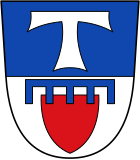
| Blazon : “Divided by blue and silver; above a silver cross of St. Anthony , below a red heart shield, raised by a 5-length blue tournament collar as a sign . " | |
| Justification of the coat of arms: The Antonius Cross is Hellenthal's landmark, it was located - within a tartsch shield - on the keystone of the main portal and as the crowning of the roof turret on the Antonius Chapel built around 1520 in Hellenthal. In the lower part of the shield the coat of arms of the noble family von Reifferscheid, because part of Hellenthal belonged to the rule and parish of Reifferscheid. |
- Description of the seal
-
"In the seal round the coat of arms of the municipality in black and white outline drawing
. Inscription above: GEMEINDE HELLENTHAL Inscription
below: KREIS EUSKIRCHEN"
Culture, sights and tourism
Museums
- Visitor mine " Grube Wohlfahrt " (Rescheid)
- ArsKRIPPANA , a nativity scene exhibition (Losheim, part of the Ardenner Cultur Boulevard )
- ArsTecnica with 110 m² model railway layout and various dioramas (Losheim, part of the Ardennes Cultur Boulevard)
- ArsFIGURA , a doll exhibition (Losheim, part of the Ardenner Cultur Boulevard)
- Weather park Weißer Stein (Udenbreth)
Buildings
- Eifel-Bärbelkreuz transmission tower
- Reifferscheid castle ruins
- Wildenburg Castle
- Olef dam
- Westwall systems
see also: List of architectural monuments in Hellenthal
tourism

- In the municipality there are numerous remains of the former Siegfried Line , u. a. at the Oleftalsperre and along the Belgian border.
- Hellenthal game reserve with the Hellenthal bird of prey station
- In the districts of Udenbreth and Hollerath, winter sports are offered with ski slopes, toboggan hills and cross-country ski trails.
- The Eifel-Höhen-Route cycle path , which runs around the Eifel National Park , leads through the village .
- The valley route cycling route also leads through the village.
- There are also some local bike tours:
- Hellenthal Oleftalsperre circular route (13.5 km)
- Urftseeroute Gemünd-Urfttalsperre and back (approx. 20 km)
- Hellenthaler Höhenroute (25.5 km)
- Oleftalbahn (see traffic)
traffic
The municipality of Hellenthal is located in the catchment area of the A1 . The B 265 runs through the municipality in a north-south direction; in the south the B 421 touches the community.
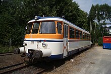
Hellenthal is the end point of the Oleftalbahn from Kall , with another train station in Hellenthal-Blumenthal. Since autumn 2010 there have been tourist trips with a historic MAN rail bus to Hellenthal every Sunday and public holiday in the summer half-year.
Another station was in Hellenthal-Losheim on the Vennquerbahn, which was dismantled in 2004 . This led from Jünkerath across the Belgian border to Waimes and Malmedy .
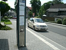
The central connection point in local public transport is the Hellenthal bus station . From there there is a connection with the RVK line 829 through the Schleiden Valley to Kall. The connection of the districts to the bus station is made via other bus lines. These are mostly used as a dial-a-bus, i. H. served by appointment by telephone.
Sons and daughters of the church
- Werner Doyé (1942–2019), television journalist, filmmaker and editor
- Willibald Kirfel (1885–1964), Indologist from Reifferscheid
- Carl Pirath (1884–1955), transport scientist
- Albert Poensgen (1818–1880), from the Kirschseiffen district, industrialist
- Julius Poensgen (1814–1880), from the Kirschseiffen district, industrialist and councilor of commerce
- Karl Reger (* 1930), auxiliary bishop in the diocese of Aachen
- Eugen Virmond (1844–1906), chronicler
- Reinhold Wirtz (1842–1898), architect and diocesan master builder
Connected to the community
- Hermann Ritter (1864–1925), teacher in Reifferscheid from 1895 to 1904, writer
- Fritz von Wille (1860–1941), landscape painter, lived temporarily in Reifferscheid (from 1899 to 1905 and from 1908 to 1911)
Web links
Individual evidence
- ↑ Population of the municipalities of North Rhine-Westphalia on December 31, 2019 - update of the population based on the census of May 9, 2011. State Office for Information and Technology North Rhine-Westphalia (IT.NRW), accessed on June 17, 2020 . ( Help on this )
- ↑ Landesbetrieb IT.NRW: Kommunalprofil Hellenthal
- ^ Manfred Niemeyer (ed.): German book of place names . De Gruyter, Berlin 2012, ISBN 978-3-11-018908-7 , pp. 255 .
- ↑ History on: hellenthal.de, accessed on April 14, 2017
- ↑ Werner Rosen: Eifelverein Hellenthal, a centenarian celebrates his birthday - the nucleus of a new Europe of peace-loving peoples . In: Eifelverein (ed.): The Eifel . Issue 3/2009, ISSN 0176-8255 , p. 17 ( online [PDF; 3.6 MB ]).
- ↑ Martin Bünermann: The communities of the first reorganization program in North Rhine-Westphalia . Deutscher Gemeindeverlag, Cologne 1970, p. 100 .
- ^ Federal Statistical Office (ed.): Historical municipality directory for the Federal Republic of Germany. Name, border and key number changes in municipalities, counties and administrative districts from May 27, 1970 to December 31, 1982 . W. Kohlhammer, Stuttgart / Mainz 1983, ISBN 3-17-003263-1 , p. 309 .
- ↑ https://www.hellenthal.de/rathaus-politik/portrait/einwohnerzahlen/
- ↑ Hellenthal municipality. Overall result. May 25, 2014, accessed October 13, 2014 .
- ↑ Main statute , local law of the municipality of Hellenthal (PDF; 101 kB)
- ↑ The history of the origin of the Hellenthal coat of arms


