Kehr (Eifel)
|
Sweeping
Community Hellenthal
Coordinates: 50 ° 20 ′ 4 ″ N , 6 ° 24 ′ 29 ″ E
|
|
|---|---|
| Height : | approx. 610 m above sea level NHN |
| Residents : | 21 (Dec. 31, 2019) |
| Postal code : | 53940 |
| Area code : | 06557 |
|
St. Mary's Assumption in Kehr
|
|
| Sweeping | |
|---|---|
| State : |
|
| Region : | Wallonia |
| Province : | Liege |
| District : | Verviers |
| Municipality : | Büllingen |
| Residents: | 15 pop. |
| Post Code: | 4760 |
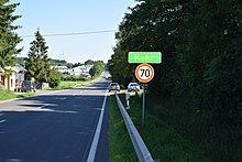
Kehr is a village in the Eifel, which is divided into two halves by the German - Belgian border. The border runs in a north-south direction along the federal highway 265, which runs right through the town . The state border between North Rhine-Westphalia and Rhineland-Palatinate also affects the town, which thus extends over three municipal areas:
- The eastern half of Kehr belongs to the municipality of Hellenthal in the Euskirchen district and is the southernmost place in North Rhine-Westphalia. Approx. 1.5 km to the southwest lies the southernmost point of North Rhine-Westphalia ( 50 ° 19 ′ 22 ″ N , 6 ° 25 ′ 32 ″ E ) on the border with Rhineland-Palatinate on the Losheimer Landgraben .
- The western half of Kehr belongs to the eastern Belgian municipality of Büllingen , where the easternmost point of Belgium is located.
- In the extreme northeast of the village there are some buildings that already belong to Rhineland-Palatinate: The area “Zur Kehr” / “Zollhaus Kehr” is part of the Hallschlag municipality .
See also: List of Shared Places
Trivia
Kehr is the setting in a crime series by the writer Martina Kempff .
Web links
Commons : Kehr, Büllingen-Hellenthal - Collection of images, videos and audio files
- Local portrait of Kehr. Municipality of Büllingen, accessed on January 21, 2016 .
- Place and street directory. Hellenthal community, accessed on January 21, 2016 .

