
Olef dam
| Olef dam | |||||||||
|---|---|---|---|---|---|---|---|---|---|
.JPG) |
|||||||||
|
|||||||||
|
|||||||||
| Coordinates | 50 ° 29 '42 " N , 6 ° 25' 18" E | ||||||||
| Data on the structure | |||||||||
| Construction time: | 1954-1959 | ||||||||
| Height above valley floor: | 54.6 m | ||||||||
| Height above foundation level : | 59 m | ||||||||
| Height of the structure crown: | 466.9 m | ||||||||
| Building volume: | 123 000 m³ | ||||||||
| Crown length: | 282 m | ||||||||
| Crown width: | 5.7 m | ||||||||
| Operator: | Eifel-Rur water association | ||||||||
| Data on the reservoir | |||||||||
| Altitude (at congestion destination ) | 465.5 m | ||||||||
| Water surface | 1.1 km² | ||||||||
| Storage space | 19.3 million m³ | ||||||||
| Total storage space : | 20.3 million m³ | ||||||||
| Catchment area | 47.92 km² | ||||||||

The Oleftalsperre dam is located near the Eifel National Park near Hellenthal in the Hohes Venn-Eifel Nature Park in the Euskirchen district ( North Rhine-Westphalia ). The reservoir holds around 20 million cubic meters and is fed by the Olef River.
description
The Oleftalsperre was built between 1954 and 1959 by the Rurtalsperren - Gesellschaft GmbH Aachen. It serves to protect the surrounding communities from flooding and to obtain drinking water through the Oleftal waterworks in Hellental. 1962–1965 the first reinforcement was built. In 1965 the valley was completely filled with water for the first time and the dam was officially opened. Another reinforcement followed in 1982–1986 under the contractor at the time for the Eifel - Rur - Headquarters Düren. The two reinforcements were necessary because the constraints, temperatures and shrinkage of the concrete caused greater internal stresses than anticipated and, as a result, cracks occurred. The air side , which was initially open , was closed in order to limit the temperature differences. The dam is made of concrete as a pillar cell construction and is still considered unique in Germany.
Other purposes of the dam are to increase the low water level in the olefs, to provide process water and to generate energy. The power plant expansion capacity is 3 MW, the annual working capacity 2.6 GWh. The storage power plant is operated by RWE Innogy .
The dam belongs to the Eifel-Rur water association . Due to its proximity to the Belgian border, its western half is already in the security area of the Elsenborn military training area in the Belgian municipality of Bütgenbach .
The shortest circular route around the reservoir is 13 km long. It leads directly along the lake and is also passable for bicycles. Its north side is largely paved.
At the beginning of April 2007, the air side of the dam was designed by the artist Klaus Dauven with high-pressure cleaners as part of the Wildwechsel project . It shows forest and water animals in the area.
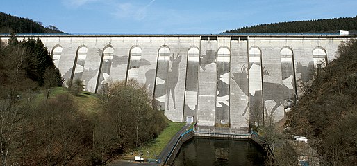
Dam in the long shot with Klaus Dauvens "Wildwechsel"

Inspection corridor inside the dam

Safety areas at the Oleftalsperre


See also
literature
- Felix Gerhardus: The construction of the Oleftalsperre. In: home calendar of the district of Schleiden. 9, 1959, ISSN 0441-6538 , pp. 56-68.
swell
- ↑ There is only one other pier dam in Germany, which, however, belongs to the subgroup of vaulted dams, namely the Linach dam .
- ↑ Artist “painted” completely filthy dam Aachener Zeitung from April 4, 2007, accessed on August 26, 2020