
Obersee (Rur)
| Obersee | |||||||||||
|---|---|---|---|---|---|---|---|---|---|---|---|
 |
|||||||||||
|
|||||||||||
|
|||||||||||
| Coordinates | 50 ° 36 '20 " N , 6 ° 23' 33" E | ||||||||||
| Data on the structure | |||||||||||
| Construction time: | ? –1959 | ||||||||||
| Height above valley floor: | 27 m | ||||||||||
| Height above foundation level : | 33 m | ||||||||||
| Height of the structure crown: | 283 m above sea level NN | ||||||||||
| Building volume: | 320,000 m³ | ||||||||||
| Crown length: | 280 m | ||||||||||
| Crown width: | 14.0 m | ||||||||||
| Base width: | 135 m | ||||||||||
| Slope slope on the air side : | 1: 1.5; 1: 2.5 | ||||||||||
| Slope slope on the water side : | 1: 1.75 | ||||||||||
| Operator: | Eifel-Rur water association | ||||||||||
| Data on the reservoir | |||||||||||
| Altitude (at congestion destination ) | 279.6 m above sea level NN | ||||||||||
| Reservoir length | - 4.8 Rur river km (only Obersee) - 5.15 Rur river km (Obersee with pre- dam ) - 13.4 km (to the dam ) |
||||||||||
| Storage space | 17.9 or 20.8 million m³ | ||||||||||
| Total storage space : | 23 million m³ | ||||||||||
| Design flood : | 370 m³ / s | ||||||||||
| Particularities: |
Main pre-basin of the Rur reservoir, drinking water storage |
||||||||||
 |
|||||||||||


The Oberseestrasse near Simmerath in the North Rhine-Westphalia Aachen region is the main Vorbecken of at Rur in the Eifel located Rurstausees (Rurtalsperre Schwammenauel) . Its barrier structure is the Paulushofdamm . The dam , like that of the Rur reservoir, belongs to the Eifel-Rur water association . The reservoir is used, among other things, to supply drinking water .
Geographical location
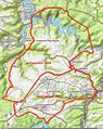
Consisting Paulushofdamm and Oberseestrasse existing dam Oberseestrasse is located in the in Rureifel , a part of the Nordeifel , southwest of the Kermeter , north of the three Hochfläche and east of Monschauer Heckenland near Simmerath (Aachen region). It is located directly below the Urfttalsperre , which accumulates the water from the Urft coming from the east to the Urftstausee, and directly above the Rurtalsperre, which holds back the water from the Rur to the Rurstausee. While the entire complex is part of the Hohes Venn-Eifel Nature Park , the large eastern arm of the Obersee to the north lies in the Eifel National Park .
Paulushofdamm

The Paulushofdamm ( ⊙ ) stands directly southwest of the Honigberg ( 495.4 m ), an elevation of the Kermeter , and a few hundred meters south-southeast of the Simmerath part of the municipality Rurberg . It is located directly above or south of the Rur reservoir, the water surface of which extends to the air side of the Paulushof dam when it is fully blocked .
During the second expansion of the Rurtalsperre from 1955 to 1959, the Paulushof dam was also raised by 14 m and the interior of the clay core seal was raised further. The old support body , now on the inside, consists of tamped valley gravel, the new outer support body consists of vibrated rock fill . The building volume is 320,000 m³. From a bird's eye view, the slightly sickle- shaped dam is 280 m long, 14 m at the crown and 135 m wide at its base, and 33 m high. The top of the dam is at a height of 283 m . In the direction of the southern slope, the dam has a 20 m wide and 60 m long weir .
In 1958, after completion of the 2nd expansion stage, the previous Rursee is dammed for the first time. Rurhöhe at Einruhr 1958: 281 m . About 7 m higher than 1938 with 274 m . As a result of the elevation, the Obersee now reached Einruhr and the barrier structure of the Urfttalsperre.
About 200 m to the west of the dam, the Eiserbach dam is also directly abutting the Rurstausee as a further pre-dam of the Rur dam , which holds back the Eiserbach water coming from the west in the Eiserbach pre-basin.
Reservoir
The Obersee extends in the Aachen city region between the Simmerath districts of Einruhr in the south and Rurberg in the north. In particular, it dams the water of the Rur. In the event of flooding, it receives additional water from the Urft via the overflow of the Urft dam.
The upper lake drained upon reaching the water level (Normal jam) of 279.6 m in the deeper main lake and is about 4.8 Rur flow kilometers long, with 3.4 km in a straight line between the end of the lake and dam are. Its volume is then 17.9 million m³. If the main lake also reaches 279.6 meters, the water surface forms a continuous body of water between the main and Obersee. If this common body of water rises to the reservoir target of the main lake (+ 2 m), then the Obersee has reached its total reservoir of 21 million m³. Directly in front of the southern end of the Obersee there is a pre-dam with an almost 350 m long fore basin around 900 m southwest of Einruhr; The Obersee and the foothills are together 5.15 km long. The reservoir root of the water is 13.4 km away from Paulushofdamm .
The Rur also forms the natural reservoir drain; however, the course of the river below the Paulushofdamm is usually dammed by the water body of the main lake. From a reservoir height of 279.6 m in the main lake, its water body joins that of the Obersee via the weir in Paulushofdamm.
The artificial runoff is the 3.7 km long Heinrich Geis tunnel leading northwest to the Kallstausee , which is fed from the Rurberg pumping station via an ascending pipeline .
use
Drinking water extraction
The upper lake is also used as drinking water - reservoir . So-called raw water for drinking water treatment is taken from the reservoir. The Rurberg pumping station pumps the extracted water through the Heinrich Geis tunnel into the Kalltalsperre. From there there is another tunnel connection (Kallstollen) to the Dreilägerbachtalsperre , with a drinking water treatment plant below it, from which the drinking water network for the Aachen district, Vaalser area and parts of the Heinsberg district is fed.
Recreation and water sports

Rur, Ober and Urft reservoirs together form a popular local recreation area. The operator of the dams, the Eifel-Rur water association or the Cologne district government, has issued conditions of use for the use of the waters. The use of the Obersee is not permitted for water sports enthusiasts (drinking water extraction room).
Only electric passenger ships , the Eifel (lead-acid batteries), the St.Nikolaus (lithium-ion batteries) and the Seensucht catamaran (lithium-ion battery) operated by the Rursee shipping operate on the Obersee . From the beginning of May to the end of October, the ships operate according to the timetable from Einruhr via the Paulushofdamm , located near Rurberg, to the Urft dam.
Swimming is prohibited in the Obersee, with the exception of the Einruhr nature adventure pool, a natural pool integrated into the lake at Einruhr .
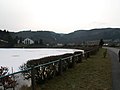
Paulushofdamm:
in the background the pumping station with weir
Weir with pumping station on Paulushofdamm
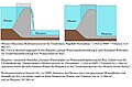
Schematic representation of the function of the weir in Paulushofdamm
Upper Lake, the eastern arm was, like the Urftstausee , in the former military training area Vogelsang involved


Inflows and outflows
The tributaries of the Obersee include - if known - length in kilometers (km) and their confluence area (sorted alphabetically):
- Elfesbach (1.9 km); flows from the east into the southern arm
- Erkensruhr (12.2 km); flows from the south-south-east into the southern arm
- Friedenbach (1.1 km); flows into the east arm from the north
- Rur (164.5 km); flows as the main tributary from the south into the southern arm; is the only natural drainage (north), the Heinrich Geis tunnel serves as an artificial one
- Urft (46.3 km); flows over the overflow of the Urft dam from the east into the east arm during flooding
- Walbigbach (2.2 km); flows into the east arm from the south
References and comments
- ↑ a b c d e f g h i j k l m n o p q r The Rurtalsperre (PDF, 1.65 MB) In: wver.de . Eifel-Rur water association (WVER). Retrieved May 7, 2016.
- ↑ a b c d Unknown / not researched source
-
↑ a b c
regard to height data: " NHN -height = NN -Height + 0.036 m" ;
see p. 2 → footer in Die Rurtalsperre , Wasserverband Eifel-Rur (WVER), accessed on May 7, 2016, on wver.de (PDF; 1.65 MB) - ↑ a b c d e Topographical Information Management, Cologne District Government, Department GEObasis NRW ( information )
- ↑ a b List of dams North Rhine-Westphalia (PDF; 121.1 KB) State Office for Nature, Environment and Consumer Protection North Rhine-Westphalia -LANUV. October 20, 2005. Retrieved September 9, 2013.
- ↑ Norbert Becker, 1988
- ↑ Willi Weiskorn: 100 years of drinking water on site ( Memento from March 5, 2014 in the Internet Archive ) ( Enwor ), from April 2009, accessed on May 7, 2013 (PDF; 991.93 KB)
- ↑ Water sports and leisure activities at Rur- / Obersee . In: Rursee - my territory . Günter Becker. Retrieved September 9, 2013.
- ↑ Regulatory authority ordinance for the approval and regulation of public use at the Rurtalsperre Schwammenauel and the Heimbach and Obermaubach dams , dated June 29, 2015, item 299, pp. 237–243 (PDF; 4.92 MB)
- ↑ Terms of use for the use of the dams of the Eifel-Rur water association ( Memento from August 23, 2007 in the Internet Archive ) ( Eifel-Rur water association ; WVER), from June 27, 2013, accessed on May 7, 2016, from wver.de ( PDF; 15.90 KB)
- ↑ Klaus Pesch: Passenger ship on a journey - St. Nikolaus is launched in the Eifel. In: Rhein-Sieg Rundschau. February 25, 2018, accessed April 20, 2018 .
- ↑ Rursee shipping . Rursee-Schifffahrt KG Schwammenauel. Retrieved September 9, 2013. (official homepage)
See also
Web links
- Level data: time series selection - Rurtalsperre Obersee basin level (Rurtalsperre) . In: wver.de . Eifel-Rur water association (WVER). Retrieved May 7, 2016.