
Simmerath
| coat of arms | Germany map | |
|---|---|---|

|
Coordinates: 50 ° 36 ' N , 6 ° 18' E |
|
| Basic data | ||
| State : | North Rhine-Westphalia | |
| Administrative region : | Cologne | |
| Circle : | City region Aachen | |
| Height : | 543 m above sea level NHN | |
| Area : | 110.92 km 2 | |
| Residents: | 15,404 (Dec. 31, 2019) | |
| Population density : | 139 inhabitants per km 2 | |
| Postal code : | 52152 | |
| Primaries : | 02473, 02485 | |
| License plate : | AC, MON | |
| Community key : | 05 3 34 028 | |
| LOCODE : | DE SRH | |
| Community structure: | 17 districts | |
| Address of the municipal administration: |
Rathausplatz 52152 Simmerath |
|
| Website : | ||
| Mayor : | Karl-Heinz Hermanns ( CDU ) | |
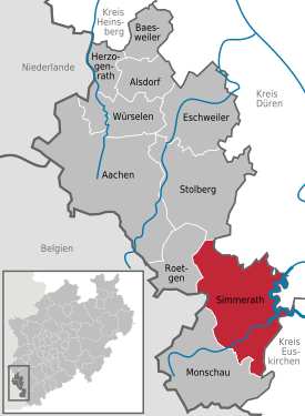
| Location of the municipality of Simmerath in the Aachen city region | ||
 .svg) |
||

Simmerath is a municipality in North Rhine-Westphalia and belongs to the city region of Aachen ( Cologne district ). The eastern half of the community is dominated by the Rursee .
geography
The current municipal area of Simmerath, which was created in 1972, extends in a radius of about 10 km around the core town. Its periphery touches the Rurtalsperre in the east, which is a relevant tourist attraction , in the south the Monschau area , in the west the Belgian border with parts of the Siegfried Line still easily recognizable by a hiking trail and in the north the Roetgen / Aachen area . The highest point in the community is the Langschoss elevation at 583 m above sea level. NHN in the Lammersdorf district. Parts of the community area have been on the territory of the Eifel National Park since January 1, 2004 .
Neighboring communities
Simmerath's neighboring communities are Raeren , Roetgen , Stolberg (Rhineland) , Monschau , Hürtgenwald , Nideggen , Heimbach (Eifel) and Schleiden
Districts
history
The area around Simmerath was already settled during the Roman Empire. The ancient connecting road led from Konzen via Simmerath and Kesternich to Einruhr . The settlement is documented by finds from the 2nd and 3rd centuries, but not by written sources. Settlement continuity into the Franconian period is not documented. A “Hof zo Semmenrode” can only be found again in a mediaeval source from 1342. The canonical evidence begins in 1346; previously the parish belonged to Konzen.
Territorially, the settlement belonged to the rule of the Counts of Monschau ( Montjoie ); this went after the death of Johann III. from Schönforst -Montjoie to the Duchy of Jülich in 1433 , in whose possession Simmerath and the entire Monschauer Land remained until the end of the 18th century. After the entire Left Bank of the Rhine was occupied during the First Coalition War in 1794 , the area belonged to France from 1798 to 1814 . Simmerath and the surrounding area belonged to the canton of Montjoie in the Aachen arrondissement in the Rur department . Due to the 1815 at the Congress of Vienna agreements reached, the region came to the Kingdom of Prussia and Simmerath was from 1816 a municipality in the district of Monschau in the administrative district of Aachen in the Grand Duchy of the Lower Rhine which in 1822 in the Rhine Province opened and until the dissolution of the Second World War was. During the Second World War, the Ardennes offensive in the winter of 1944/45 caused severe damage as the Allies marched.
As part of the territorial reform in North Rhine-Westphalia , the so-called Aachen Act of December 14, 1971 with effect from January 1, 1972, incorporated the previously independent communities of Eicherscheid, Kesternich, Lammersdorf, Rurberg, Steckenborn and Strauch into the municipality of Simmerath and the district Monschau dissolved. This expanded Simmerath has since been one of nine municipalities (alongside Herzogenrath , Alsdorf , Würselen , Baesweiler , Eschweiler , Stolberg , Roetgen and Monschau ) that, after the reorganization, belong to the former Aachen district, today's Aachen city region .
Lammersdorf was already part of the Simmerath office , Kesternich, Rurberg / Woffelsbach, Steckenborn and Strauch were independent, Eicherscheid was previously with Imgenbroich and Einruhr / Erkensruhr with Dreiborn . As a result of the incorporation, some of the localities that (along with others) had already belonged to Simmerath under church law in the Middle Ages, were “brought back” to Simmerath in terms of local politics, namely Dedenborn, Kesternich, Strauch, Rollesbroich, Witzerath, Lammersdorf and Paustenbach. In the meantime, however, each of these districts has developed its own identity and its own economic factors, so that the municipality of Simmerath today presents itself as an amalgamation of heterogeneous structures.
politics

Municipal council
In the municipal council election on May 25, 2014 , the following distribution of seats resulted:
mayor
The full-time mayor was Hubert Breuer (CDU) until October 20, 2009. On October 21, 2009, Karl-Heinz Hermanns (CDU) succeeded him. Arnold Steins was the community director until 1999.
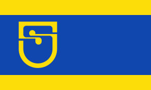
Coat of arms, banner and flag
The municipality of Simmerath was granted the right to carry a coat of arms, a seal, a flag and a banner with a certificate from the district president in Cologne dated December 9, 1975.
coat of arms
|
|
Blazon : "In blue a golden (yellow) S." |
| Justification of the coat of arms: The community coat of arms represents a blue S on a golden background. The S symbolizes the new community of Simmerath, which was created after the local reorganization in 1972, and its location on the Rursee . The golden coat of arms is intended to indicate that it belonged to the Jülich regional rule . |
Banner and flag
flag

banner


Coat of arms of Alt-Simmerath

Description of the banner: "The banner of the community is yellow-blue-yellow in a ratio of 1: 4: 1 with longitudinal stripes with the coat of arms moved upwards slightly above the center and without a shield."
Description of the flag: "The flag of the municipality is yellow-blue-yellow in a ratio of 1: 4: 1 with horizontal stripes with the coat of arms moved towards the pole and without a shield."
Community contacts
- Lendelede , Belgium
- Shields , Belgium
- Maubert-Fontaine , France
Culture and sights


Museums
- Lammersdorf farming museum , a farming ensemble from around 1900
- Natural history education center North Eifel
- National Park Gate Rurberg with an exhibition on the flowing waters in the NP and still waters - dams - around the national park
- Heilsteinhaus with national park information point in Einruhr, fountain system freely accessible in the inner courtyard
War cemetery
- Soviet war cemetery Simmerath-Rurberg . Simmerath received the care of this war cemetery. Russian dead from the Second World War from the wide area were buried here. The entrance hall is also an award-winning building.
Buildings
- The Johanneskapelle (1665) is the oldest surviving structure in the town center. When the B 399 was expanded in 1968, it had to be moved around 100 m.
- According to Giebel, a Winkelhof complex typical of the North Eifel (Hauptstrasse 63) dates from 1781, but could be older (which cannot be proven due to major changes in the building).
- Most of today's Simmerath building fabric dates from after 1950. The Simmerath town hall, architecturally angled and provided with an octagonal fountain, dates from 1975.
- The other sights and tourist attractions of the municipality of Simmerath are not located in the core town, but in the districts incorporated in 1971 (described there).
Attachment
In 2014, the ground monument was added to the list of monuments of the municipality of Simmerath under the false name Fortification Meyssenburg , from the 14th century, on the outskirts of Huppenbroich.
biology

A planned expansion of the industrial area is made questionable by a biological rarity. In this wetland near Kesternich there is an island population of the extremely rare blue iridescent fire butterfly (Lycaena helle) , a species of butterfly the size of a fingernail that is threatened with extinction. The location is remarkable as the population here is one of the largest in Europe.
natural reserve
Economy and Infrastructure
traffic
Road connection
The federal highways 399 (Düren - Belgian border) and 266 (Simmerath - Linz am Rhein) run through the town center . The nearest motorway connections are to the A 44 and A 4 near Aachen and to the A 1 near Mechernich .
Public transport connection
At the bus station in Simmerath ( Simmerath Bushof ) various regional bus routes from various directions meet. There are connections u. a. to Aachen and Monschau. The formerly important Vennbahn , still used as a museum railway until 2001 , which had a train station in Lammersdorf , has been decommissioned and was dismantled in 2010 to build the international Vennbahn cycle path .
Bus route overview:
| line | course |
|---|---|
| 63 | Simmerath - Einruhr - Vogelsang (- Schleiden ) |
| 68 | (Lammersdorf -) Simmerath Bushof - Strauch - Steckenborn - Woffelsbach - Rurberg (- Einruhr) |
| 81 | ( Vossenack - Zweifallshammer -) Schmidt - Steckenborn - Strauch - Kesternich - Simmerath Hospital - Simmerath Bus Station |
| 82 | Simmerath Bushof (- Konzen) - Imgenbroich Bushof - Monschau parking garage |
| 83 | Simmerath Bushof - Huppenbroich - Eicherscheid - Hammer - Dedenborn - Einruhr - Erkensruhr |
| 86 | Vossenack - Raffelsbrand - Lammersdorf, Junker - Lammersdorf - Paustenbach - Simmerath bus station |
| SB63 |
Express bus: Aachen Bus Station - Elisenbrunnen - Misereor - Aachen Hbf - Marienhospital - Burtscheid - Oberforstbach - Roetgen - Lammersdorf - Rollesbroich - ( Witzerath -) Simmerath |
SB86 Simmerath Bus Station - Vossenack - Düren Bahnhof / ZOB
The Aachener Verkehrsverbund (AVV) tariff and the Euregio ticket apply on all lines .
Established businesses
The heterogeneous economic structure of the community of Simmerath is explained by the different geographical location and history of the individual districts. The core town and the surrounding area are dominated by industry and dominated by craft and service companies with the central vocational training and trade promotion center (BGZ), founded in 1969 and opened in 1972 as a cooperation measure between the Aachen Chamber of Crafts and the trade union IG Bau-Steine-Erden and the sponsorship community of the craft in the Aachen region e. V. This is where cross-company training for all construction and finishing trades , for roofers - as well as for carpenters - and the bakery trade is concentrated . In 2011, the BGZ was also the first and only in the Aachen chamber district to be equipped with an innovative deep rescue system, which can be used to train rescue teams from great depths. In contrast, Dedenborn, Steckenborn and Strauch have an agrarian character and tourism is the main source of income for the districts located on the Rursee and in the vicinity of the national park, i. H. Rurberg, Woffelsbach, Einruhr and Erkensruhr / Hirschrott.
The largest resident company is Otto Junker GmbH in Lammersdorf: Manufacture of industrial furnaces and stainless steel foundry
Public facilities
The Eifelklinik St. Brigida is a privately owned hospital with 99 beds. The hospital was sold to Artemed clinics in August 2010 due to financial difficulties of the then Maltese sponsoring company and renamed the Eifelklinik St. Brigida.
schools
The school landscape in the municipality of Simmerath consists of the three primary schools in Simmerath, Lammersdorf and Steckenborn, a special needs school in Eicherscheidt and the two secondary schools in Simmerath and Hürtgenwald. The vocational college Simmerath-Stolberg and the vocational training and trade promotion center (BGZ) in Simmerath are available for professional training. In addition, there is the possibility to visit the adult education center in Monschau and the natural history educational center in North Eifel in Lammersdorf.
Personalities
- Helena Stollenwerk (1852–1900), founder of the order
- Berthold Wolff (1901–1949), textile merchant
- Theo Schwonzen (1920–2014), physician
- Berta Kals (1923–2016), artist (known for Christmas cribs that are critical of the times and society)
- Raimund Krämer (* 1952), political scientist and editor-in-chief of the specialist journal WeltTrends
- Marie Zimmermann (1955–2007), journalist, dramaturge, theater director
- Elke Pistor (* 1967), writer
- Inga Braune (* 1981), artist
- Jens Brandenburg (* 1986), politician of the FDP
- Sven Goebel (* 1988), Guinness world record holder and martial artist
- Andreas Korte (* 1989), soccer player
- Noah Katterbach (* 2001), soccer player
Web links
Individual evidence
- ↑ Population of the municipalities of North Rhine-Westphalia on December 31, 2019 - update of the population based on the census of May 9, 2011. State Office for Information and Technology North Rhine-Westphalia (IT.NRW), accessed on June 17, 2020 . ( Help on this )
- ^ Federal Statistical Office (ed.): Historical municipality directory for the Federal Republic of Germany. Name, border and key number changes in municipalities, counties and administrative districts from May 27, 1970 to December 31, 1982 . W. Kohlhammer, Stuttgart / Mainz 1983, ISBN 3-17-003263-1 , p. 309 .
- ^ Rolf Nagel: Rheinisches Wappenbuch . Rheinland Verlag, Cologne 1986, ISBN 3-7927-0816-7 , p. 197 .
- ↑ A small butterfly causes almost unsolvable problems in Eifler Nachrichten January 27, 2009, page 13, Nordeifel
- ↑ Ernst Schneiders: Simmerath Hospital: Malteseros succeeds in surprise coup. In: Aachener Nachrichten. August 13, 2010. Retrieved November 11, 2017 .
Dedenborn | Eicherscheid | Einruhr | Erkensruhr | Hammer | Deer scrap | Huppenbroich | Kesternich | Lammersdorf | Paustenbach | Rollesbroich | Rurberg | Simmerath | Steckenborn | Shrub | Witzerath | Woffelsbach

Aachen | Alsdorf | Baesweiler | Eschweiler | Herzogenrath | Monschau | Roetgen | Simmerath | Stolberg (Rhineland) | Würselen