Dedenborn
|
Dedenborn
community Simmerath
Coordinates: 50 ° 34 ′ 54 ″ N , 6 ° 21 ′ 10 ″ E
|
||
|---|---|---|
| Height : | approx. 370 m | |
| Residents : | 399 (December 31, 2011) | |
| Postal code : | 52152 | |
| Area code : | 02473 | |
|
Location of Dedenborn in North Rhine-Westphalia |
||
|
Dedenborn
|
||

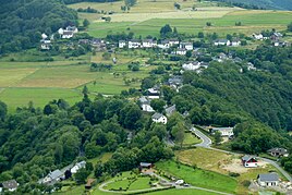
Dedenborn is a district of the municipality of Simmerath in the Aachen city region .
geography
Geographical location
It is located on the Rur approx. 10 km east of Monschau on the L106 to the Rurtalsperre in the northern Eifel .
geology
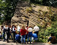
The place is built on rocks of the Lower Devonian , which are called Rurberg layers. It is a sequence of sedimentary rocks, consisting of dark gray clay slate , in which individual Grauwacken banks are embedded, which were deposited on a low-lying shelf area during the Pragian period about 410 million years ago. During the Variscan orogeny , some 300 million years ago, these deposits were folded. At the south-western exit of the town there is a special tectonic phenomenon known as the Mullion structure, which in the Eifel only occurs between Einruhr and Monschau.
history
The beginnings of the place are in the dark, although local researchers from the Eifelverein are trying to systematically come to terms with it. Some teachers on site have made contributions in this regard through publications. In 1559 the place name Dedenborn was first found in a tax list (kept in the Düsseldorf State Archives ). A parish church (daughter church of the parish of Simmerath) received the place according to the dating above the portal in 1717.
Like the entire Monschauer Land, Dedenborn belonged to the Duchy of Jülich from the time of its presumed creation until the end of the 18th century . After the entire Left Bank of the Rhine was occupied during the First Coalition War in 1794 , the area belonged to France from 1798 to 1814 . Simmerath and the surrounding area belonged to the canton of Montjoie in the Aachen arrondissement in the Rur department . Due to the agreements reached at the Congress of Vienna in 1815 , the area was assigned to the Kingdom of Prussia , and from 1822 until the end of World War II it was part of the Rhine Province . During the Second World War, the place was spared because it was not located directly on the Siegfried Line.
By the law of the state of North Rhine-Westphalia on the reorganization of the communities and districts of the reorganization area Aachen (the so-called Aachen law ) of December 14, 1971, Dedenborn (formerly district of Dreiborn ) was assigned to the community of Simmerath on January 1, 1972.
In the 20th century, Dedenborn initially did not benefit from the up-and-coming tourism in the course of the second expansion stage of the Rurtalsperre (1955–1959). It is 5 km from the water on a plateau in the middle of agriculturally used areas. This only changed with the establishment of the Eifel National Park and the establishment of a new nature trail based on an older nature trail along the Rur floodplains between Einruhr and Dedenborn; Nevertheless, the place has retained its rural character and, even at the beginning of the 21st century, is not yet geared to the permanent accommodation of holiday guests.
Culture and sights
Buildings

- The Catholic parish church of St. Michael (1717), originally a small single-nave building, was extended by a transept in the 20th century. The interior decoration (reliefs of the Way of the Cross, crucifixion group, Saint Michael) is rural baroque (18th century).
Natural monuments
- Above the village there is a small slope with which Timo Löhrer achieves a privately financed assortment of 20 bottles per year in an area where there is no official viticulture . On June 28, 2003 , the WDR presented the Dedenborn hobby winemaker in the local time program .
- The geologist Wolfgang Schmidt discovered a tectonic structure in 1952 when a new section of highway 106 to Monschau was being built, which was not known in the rest of the Rhenish Slate Mountains . Because of the similarity of the surface structures with the framework of Gothic church windows in England, such a formation is called mullion (this corresponds to the English word for framework ). The rock is a frequent destination for geological teams of experts.
- Although the approx. 5 km long circular hiking trail between Dedenborn and Einruhr lies outside the Eifel National Park , it is integrated into the nature conservation concept. The short south end of the Obersee south of the stone bridge of Einruhr is a biotope with breeding islands for the little ringed plover and on a 2 km nature trail. Between the wet meadows along the Roer ( Seifenauel and Rauchenauel ) and the edge of the forest there are reeds -Vegetation and Hochstaudenfluren .
- The Schöne Aussicht is a historical vantage point high above the southern end of the Obersee between Dedenborn and Einruhr . District Administrator Bernhard Paul Friedrich Hugo von Scheibler , who accompanied Friedrich Wilhelm IV. On his visit to the Monschauer Land, erected a stone cross there in 1887, which has since been renewed several times. Only the base, which bears the district administrator's family coat of arms, is still the original. The view from here in the direction of Dedenborn is still a motif for Eifel local painters in recent times.
- The cycle paths lead through the village :
- Eifel-Höhen-Route , which leads as a circuit around the Eifel National Park .
- RurUfer cycle path , which connects the highest point of the High Fens with the confluence of the Rur and the Meuse .
- Dedenborn is crossed by numerous main and long-distance hiking trails:
- Matthiasweg , which as the main hiking trail 6 of the Eifelverein connects Aachen with Trier.
- Eifelsteig , a premium hiking trail that crosses the Eifel from Aachen to Trier in 15 stages. Stage 3 from Monschau to Simmerath-Einruhr touches the municipality of Dedenborn.
- Wilderness Trail , which, as a nature trail in the Eifel National Park, leads in four stages from Monschau-Höfen to Hürtgenwald-Zerkall. Stage 1 from Monschau-Höfen to Simmerath-Einruhr touches the municipality of Dedenborn.
Regular events
- annual shooting festival over Pentecost, well-known far beyond the borders of Dedenborn, organized by the St. Michael Schützenbruderschaft Dedenborn 1932 eV
- Annual barbecue on October 3rd at the grill hut "Spicher", organized by the Dedenborn tourist office from 1969
Youth tent site Dedenborn
There is a youth campsite in the Ruraue, which was rented to youth groups as early as the 1930s. He is from the pathfinder tribe DPSG tribe Maximilian Kolbe e. V. Lammersdorf looks after and has space for around 100 people.
literature
- Karl Wirtz: Local history of Dedenborn . In: The Hermit on the High Fens . 4th year, no. 4 . Monschau January 1929, p. 49–59 ( Digital Collections of the University of Cologne [accessed on August 8, 2015]).
- Karl Wirtz: Local history of Dedenborn . (Enough). In: The Hermit on the High Fens . 4th year, no. 5 . Monschau February 1929, p. 69–78 ( Digital Collections of the University of Cologne [accessed on August 8, 2015]).
- Alfons Graß: 275 years of the parish church of St. Michael Dedenborn, 1992
- Alfons Graß: Beechnuts in exchange for writing and arithmetic books. 1996 (everyday school life in Dedenborn)
Web links
- official homepage
- Photo of Mullion Rocks ( Memento from October 6, 2007 in the Internet Archive )
- Geological dissertation on the Eifel (PDF file; 6.41 MB)
- Forest nature trail Einruhr / Dedenborn
Individual evidence
- ↑ Population figures in the community of Simmerath (main residence) at www.simmerath.de
- ↑ Hans-Ulrich Schmincke: Contribution to the chapter "Mullion structure" . N. yearbook f. Geologie Paläontologie, Mh. 5, pp. 225-235, 1961.
- ^ Federal Statistical Office (ed.): Historical municipality directory for the Federal Republic of Germany. Name, border and key number changes in municipalities, counties and administrative districts from May 27, 1970 to December 31, 1982 . W. Kohlhammer, Stuttgart / Mainz 1983, ISBN 3-17-003263-1 , p. 309 .
- ^ Dedenborn youth campground


