
RurUfer cycle path
| RurUfer cycle path | |
|---|---|

|
|
| overall length | 180 km |
| location | High Fens , Eifel / Belgium , North Rhine-Westphalia , Netherlands |
| Starting point | "Signal de Botrange " |
| Target point | The mouth of the Rur in the Maas (mouth of the Rur) in Roermond |
| Places along the way | Kalterherberg , Monschau , Dedenborn , Einruhr , Rurberg , Woffelsbach , Heimbach , Obermaubach , Untermaubach , Üdingen , Nideggen , Düren , Jülich , Broich , Tetz , Linnich , Hückelhoven , Wassenberg , Effeld , Vlodrop , St. Odilenberg |
| Flooring | mostly water-bound surface , little asphalt |
| Height difference | Botrange 690 m , Roermond 17 m / approx. 820 m up / approx. 1430 m down |
| difficulty | Upper course medium 2–6% / Düren-Roermond (approx. 110 km) flat. |
| Traffic volume | with the exception of the upper Rur valley, almost exclusively off-road. |
| Connection to | Eifel Heights Route ; Vennbahn |
| Website URL | RurUfer cycle path |
The RurUfer cycle path is a long-distance cycle path that runs along the Rur for around 180 kilometers . It begins in Belgium near the Rur springs at the highest point in Belgium, the Botrange in the High Fens , and leads to the confluence with the Meuse in Roermond, the Netherlands . The route leads through Monschau , past the Rur reservoirs and then via Heimbach, Düren, Jülich and Linnich through the Heinsberg district and the Dutch municipality of Roerdalen to Roermond. The route runs almost exclusively on separate cycle and farm roads. The route is uniformly signposted in both directions with the bike path logo. In Belgium as well as in the Netherlands through the " node system ".
Route Botrange - Roermond

Characteristic
The cycle path starts at an altitude of 690 m and leads with a medium gradient (2-6 percent) via Monschau at 517 m to the Rurstausee at around 280 m . Here you can choose between the eastern, somewhat flatter, and western, hilly banks. Both paths lead to Heimbach at about 280 m , before the last two climbs to Nideggen-Brück take the almost flat remaining stretch. Most of the route has a water-bound cover. Only a few sections are paved. With exceptions in the upper Rur valley, the route leads almost exclusively away from roads. The section Düren - Roermond does not have any significant gradients for about 110 kilometers. Therefore, this part is particularly suitable for families with children. In the Heimbach - Linnich section, the route is accompanied by the Rurtalbahn and the Düren - Jülich and Jülich - Linnich lines with many stops. Along the RurUfer-Radweg there are numerous bicycle-friendly restaurants that invite you to rest or to stay overnight.
The RurUfer cycle path is signposted throughout. In Belgium there is a very clear junction system. In the city region of Aachen and the districts of Düren and Heinsberg , the cycle path was marked with the white and red signs and also as a themed route with the cycle path logo. The junction system can also be followed on the Dutch side, whereby the route is also provided with the logo.
The touristic highlights of the tour are the scenic High Fens in the upper reaches , the old town of Monschau, the Rursee with its dam wall and the Art Nouveau power station Heimbach . In the course follow Hengebach castle , Burg Nideggen , reservoirs Obermaubach , castle Untermaubach , Castle Burgau and the Leopold-Hoesch Museum in Düren. In the flat section of the cycle path, the route leads to Düren via Jülich with the Brückenkopfpark and the Jülich Citadel and on to the Glass Painting Museum in Linnich . This is followed by the “Schacht 3” visitor mine in Hückelhoven and the city fortifications with the castle hill in Wassenberg , before reaching the end of Roermond with its old town, which is well worth seeing.
Botrange - Heimbach
The 50-kilometer section starts at the highest point in Belgium, the Botrange in the High Fens. There is a large car park on the Belgian N676. It is not possible to reach the starting point by public transport with bike transport. The company "Fahrrad Events Eifel" offers a corresponding transport option from the main train station in Aachen.
On the N676, the route leads to the southeast, towards Sourbrodt , but turns left before the village at the Botrange Nature Park Center and leads through a forest area where the Rur is reached for the first time, to Küchelscheid on the German-Belgian border. On the German side in the village of Kalterherberg there is one of the churches known as the Eifeldom, the parish church of St. Lambertus . The route now follows the course of the Rur and leads past Reichenstein Monastery to the climatic health resort of Monschau with its historic old town. The path continues through the Monschauer Land along the deeply cut Rur to Einruhr at the so-called Obersee of the Rur reservoir. The Rursee Center with the Eifel National Park is reached after four kilometers above the lake . Here you have to decide whether you want to take the western route via Rurberg and Woffelsbach or the flatter route on the eastern bank. Both routes meet again at the eastern end of the reservoir and lead down to Heimbach with its Art Nouveau power plant and Hengebach Castle. The Eifel Water Information Center and the terminus of the Rurtalbahn are also located here .
Heimbach - Jülich
This section is about 40 kilometers long. From the western dam of the Rurstausees, the Schwammenauel dam, to Kreuzau , the route leads through the Rureifel . Here the Rur has dug itself deep and steep into the ground. Strong meanders in the river cause so-called circulating mountains. Behind Heimbach, however, the valley widens, and red sandstone formations with vertically rising, wildly jagged rock towers characterize the landscape. Between Hausen and Nideggen there are two more climbs to overcome before the path is almost flat to the mouth. In Nideggen, the castle above the old town invites you to visit. Settlement is now significantly denser, and past many small places the route leads to the last reservoir in the course of the Rur, the Obermaubach reservoir. With Untermaubach the Rur leaves the last foothills of the Eifel and reaches an industrially developed area. The industrial centers begin in Untermaubach and extend over Kreuzau, Düren, Jülich to Linnich. The focus is on the paper industry, but metal processing, machine and apparatus construction and chemistry can also be found. Untermaubach also has a castle to offer. The route continues along the Rur via Üdingen and Kreuzau to the Niederau district of Düren , where Burgau Castle is located. After another four kilometers, the city center of Düren is reached. The most famous museums in the city are the Leopold Hoesch Museum and the Paper Museum . The route continues through completely flat terrain along the banks of the Rur and reaches the town of Jülich after around 18 kilometers. A visit to the citadel and the bridgehead park is particularly worthwhile.
Jülich - Roermond
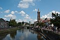
The last section, around 90 kilometers long, leads through the open arable land of the Jülich Börde . In the Heinsberg region, in front of the Dutch border, the Rurn lowlands merge into the wide Meuse plain. Scattered old arms and mansions now characterize the landscape. Along the strongly meandering river you now go to Linnich, where the German Glass Painting Museum invites you to visit. Then the moated castle Rurich is worth seeing. In Hückelhoven there is the "Schacht 3" visitor mine with the Millicher Halde vantage point , and the city of Wassenberg offers the city fortifications with the castle hill as a sight. After another 9 kilometers on the banks of the Rur, the Effelder forest lake and thus the German-Dutch border is reached. In the Netherlands the Rur or Roer as it is called here has never been regulated, so the river is in its original state. Via Vlodrop, the Dutch border town, and Sint Odiliënberg, the route then reaches its end in Roermond. The Rur divides into two branches in the Meuse lowlands. These flow through the western urban area of Roermond. They flow past the Cathedral of St. Christophorus and finally flow into the Meuse . Roermond can be reached by train via the Venlo border station .
Connecting cycle paths
In Roermond there is an interesting loop around the Maasplassen or the journey can be continued along the Maas. At the former train station of Kalterherberg there is a connection to the Vennbahnradweg and between Kalterherberg and the Rurtalsperre the Rurufer-Radweg and the circular Eifel-Höhen-Route run together. The Eifel-Höhen-Route is a panorama tour around the Eifel National Park and connects to the Kylltal-Radweg in Dahlem , the Ahrtal-Radweg in Blankenheim (Ahr) and Ahrhütte as well as the Erft-Radweg in Nettersheim .
See also
Train and bus connections
The starting point of Botrange can only be reached by public, bicycle transport on the German side as far as Heimbach. However, the company "Fahrrad Events Eifel" offers bicycle transport from Aachen main station. The nearest Belgian train station is Verviers Central. From there you can take the road N640 - Mangombroux - N672 - Secheval - Jalhay - Belle Croix - N68 - Mont Rigi - N678 towards Sourbrodt after about 21 kilometers to get to the Botrange. However, the Verviers train station is 520 meters lower than the Botrange.
On the RurUfer cycle path there are numerous train stations on the parallel line of the Rur Valley Railway between Heimbach and Linnich.
From the end point Roermond there are regular trains to Venlo or Maastricht . To get to a German train station, there is a pleasant cycle route from Roermond through the De Meinweg National Park to Dalheim . This is the terminus of the Jülich – Dalheim railway line . The Schwalm-Nette-Bahn ( RB 34 ) runs between Mönchengladbach Hauptbahnhof and Dalheim.
Landscape and culture

Eifel Cathedral in Kalterherberg

White water of the Rur in Monschau

The “Red House” in Monschau

Obersee between Einruhr and Rurberg

Aerial view of the Rurtalsperre Schwammenauel

Heimbach Art Nouveau power plant

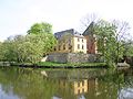
Heimbach Castle

Nideggen Castle

Obermaubach with reservoir

Red sandstone rocks near Untermaubach

Untermaubach Castle
Burgau Castle

Leopold Hoesch Museum Düren

Bucket wheel excavator in the Inden opencast mine

Headframe of shaft 3
St. Odilienberg on the Rur
Munster Church Roermond
Rur just before the confluence with the St. Christophorus Cathedral


The starting point of the route is in the High Fens-Eifel nature park at the highest point of the High Fens and Belgium on the Botrange. Here is the tower with the “Signal de Botrange” viewing platform, which offers a view of the high moor that feeds the Rur springs. In addition, the heaped Baltia hill is located here with a geodetic fixed point at 700 m OP The High Fens (French: Hautes Fagnes ) is a shield-shaped arched plateau on the border between Germany and Belgium . Large areas are designed as raised bogs . The climate is relatively harsh, in the annual mean much cooler than in the surrounding area, and very rainy. After two kilometers, the route leads past the “Botrange Nature Park Center”, which offers all information about the High Fens in French, Dutch and German. The center and the new "Fania" museum reopened in March 2013. This is followed by the transition from the High Fens to the Eifel plateau. In contrast to the High Fens, these are deeply cut by the Rur and its tributaries. These valleys form a canyon forest landscape with their wooded steep slopes and rugged rocky areas. After crossing the border to Germany, the route leads through the Monschauer Land, which stretches from Kalterherberg to the Rurstausee. The picturesque Eifel town of Monschau, a former stronghold of the cloth making industry, with its half-timbered and quarry stone houses is located there. The old town is still dominated by the 12th century castle. The next section of the route is determined by the water surface of the Rur reservoir. In addition, there is also the opportunity to explore the so-called National Park Gate to the Eifel National Park in Rurberg or to make a detour to the more than 100 year old Urftsee wall .
The RurUfer cycle path runs along both banks of the Rursee. The route on the eastern bank crosses the national park, while on the western bank it goes through the water sports resort Woffelsbach. The Rur boat trip between Rurberg and Schwammenauel can also be used to shorten the tour. After the two routes have combined and the descent to Heimbach, the Art Nouveau hydropower plant can be visited. It is located on the Rursee, but gets its water from the Urftsee, to which it is connected via two pressurized water pipes with a height difference of 110 meters. When it was commissioned in 1905, it was the most powerful hydropower plant in Europe with five megawatts. In Heimbach itself, Hengebach Castle, the Eifel Water Information Center and the Heimbach National Park Gate await visitors. The route now reaches the Rureifel. Between Heimbach and Kreuzau it is accompanied by imposing red sandstone rocks. Here you are in the former Duchy of Kleve-Jülich-Berg , the core area of today's North Rhine-Westphalia. Along the northern part of the national park and past Nideggen Castle, the route leads to the last Rur reservoir, the Obermaubach reservoir. Then the mountains disappear and, after the castles of Obermaubach and Untermaubach, are replaced by alluvial forests that stretch as far as Düren. In Düren, Burgau Castle, the traffic-calmed marketplace and museums are waiting for you to visit. The city's best-known museum is the Leopold-Hoesch-Museum, which mainly shows works of Expressionism and Classical Modernism . The path now continues to Jülich. From here, you can take a detour west to the Inden open- cast lignite mine . This can be circled on a 12 kilometer loop, with the steel Indemann observation tower providing a good all-round view. The Inde river was diverted because of the opencast mine and now meanders through the recultivated area before it flows into the Rur again at Jülich. East of the way in Niederzier is the "Haus Horn", one of the last remaining storage houses from the 17th and 18th centuries. Century. It gives an insight into the everyday life of our ancestors. The Niederzier moated castle is also located there, where the municipal administration is located today. In Jülich, the citadel from the Renaissance and the bridgehead park from the Napoleonic period are worth a visit.
The path now leads through the flat landscape of the Lower Rhine and reaches the Jülich Börde. Wide, open fields with villages scattered about them now accompany the watercourse. Once the granary of the Holy Roman Empire , it is still one of the most fertile areas in Germany today. Along the way there are numerous castles and the still visible monuments of the former coal mining area. In Linnich, you can visit the German Glass Painting Museum, which, in addition to the oldest glass painting workshop in Germany, exhibits glass works of art from the 16th century to the present day. The next sight on the way is the classical Rurich Castle with its park. After the basket-making museum in Hilfarth one arrives at the visitor mine "Schacht 3" in Hückelhoven. With the closure of the Sophia-Jacoba colliery in 1997, the almost hundred-year-old mining tradition came to an end here. A development association has preserved and restored the "Shaft 3" shaft structure , the machine house and the shaft hall. Guided tours give an impression of the coal mining industry. The Burg Wassenberg has a publicly accessible castle tower , which offers a beautiful view of the water castles of the Rur valley. Asparagus fields now dominate the landscape on the way to the Dutch border. The German-Dutch border runs 450 meters in the middle of the Rur. The Dutch write Roer, but speak the river name like Rur. The last section of the route leads along the unregulated and therefore original river to Roermond. Mediterranean-style cottage gardens and orchards accompany him. If you want to visit the city, cross the wooden bridge over one of the two mouths of the Rur and drive to the Steenbrug in the center. From there you can easily reach the churches and museums of the city, as well as the train station for your return journey.
Attractions
- Kalterherberg with its Eifeldom and the parish church of St. Lambertus. Located directly on the High Fens, this border town with Belgium is the first to experience the bad and cold weather. House-high beech windbreak hedges provide a remedy. Kalterherberg is a typical example of the Monschau Heckenland . The former Reichenstein Abbey above the Rur is also located in the municipality.
- Monschau is known for its historic old town. The 12th century castle still dominates the old town with its half-timbered and quarry-stone houses, which dates back to the heyday of early industrial cloth production. A particularly impressive example is the Rote Haus , which is now a museum and built by the Scheibler family of manufacturers around 1760 .
- Heimbach, located at the foot of the Rursee dam Schwammenauel, offers a number of attractions. These include the Art Nouveau power plant, which was the largest hydropower plant in Europe when it went into operation in 1905. The RWE Industrial Museum is located in the completely preserved Art Nouveau building, which is unique in Europe . One of the old turbines with the brass fittings customary at the time can be seen in it. The castles Hengebach and Hausen , the Eifel Water Information Center and the Heimbach National Park Gate are located up there. Near Heimbach is the Mariawald Abbey , a monastery of the Cistercian order that is still active today .
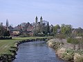
- Nideggen has a lovely old town with half-timbered and red sandstone houses. From the central market square you can see the two defiant city gates. After a ten-minute walk, past the Romanesque parish church with one of the oldest preserved frescoes in Germany, you are at the gates of Nideggen Castle. From here, a variety of hiking trails opens up around the huge rock massifs over which the castle is built visible from afar. In addition, there are several facilities of the Eifel National Park in the village.
- Düren is called "The Gateway to the North Eifel". It is shaped by more than 1,300 years of eventful history and today's modern industry. The moated castle Burgau is located in the Burgau Forest on the edge of the Niederau district. In the city there are still remains of the medieval city wall with the thick tower and the Grönjansturm . The most famous museum in town is the Leopold Hoesch Museum. The building, erected in 1905 in neo-baroque style, shows changing exhibitions of contemporary art, including expressionist paintings. Since 1986 there are also works of art of international Biennale PaperArt to see. It cooperates with the neighboring paper museum. The Inden lignite mine is located north of Düren. The Indemann lookout tower and a lookout point at the edge of the opencast mine give an impression of the mining activities.
- Jülich was 97 percent destroyed in an air raid by British bombers in 1944. Today it has one of the largest research institutions in Europe, the Jülich Research Center. The Jülich solar tower is also well known, and the Jülich Solar Institute at the Aachen University of Applied Sciences played a decisive role in its development as a solar thermal demonstration and test power plant . The city offers the two gates of the medieval city fortifications, the Aachen Gate and the Witches Tower . The citadel from the Renaissance with the Citadel Museum and the bridgehead park from the Napoleonic era are parts of the former Jülich fortress .
- Hückelhoven has a long list of listed objects. These include houses from the city's long mining history, Rurich Castle, a mansion with an English park in the Rurich district, as well as other former castles and mansions. A visitor mine was set up in "Shaft 3" of the former Sophia-Jacoba colliery.
- St. Odilenberg is a village in the Dutch province of Limburg . It is located on the Rur around five km west of its confluence with the Meuse. There is an 11th-century Romanesque basilica with two towers, dedicated to Saints Wiro, Plechelmus and Otgerus, as well as the windmill (Molen van Verbeek) from 1883.
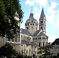
- Roermond, at the confluence of the Rur and Meuse, has a few more sights to offer at the end of the route. Among other things, the Liebfrauen-Münsterkirche from the 13th century, the Cathedral of St. Christopher from the 15th century and the town hall from 1700 with a carillon tower.

literature
- ADFC regional map Eifel / Mosel , 1: 75,000. Bielefelder Verlag, 1st edition. 2006, ISBN 3-87073-391-8 .
- RurUfer cycle path: three countries, one river: from the source in the Belgian Venn through the Eifel and Börde to the confluence with the Maas in the Netherlands , 1: 50,000. Verlag Esterbauer, 3rd edition, 2014, ISBN 978-3-85000-179-3 .
Web links
- The RurUfer cycle path (www.rureifel-tourismus.de; accessed on June 24, 2018)
- The RurUfer cycle path (www.eifel.info; accessed on February 5, 2012)
- The RurUfer cycle path (www.eifel-tipp.de; accessed on February 5, 2012; PDF; 1.7 MiB)
- Route at OpenStreetMap
Coordinates: 50 ° 29 ′ 34.5 " N , 6 ° 5 ′ 59.5" E