
Verviers
| Verviers | |||
|---|---|---|---|

|

|
||
|
|||
| State : |
|
||
| Region : | Wallonia | ||
| Province : | Liege | ||
| District : | Verviers | ||
| Coordinates : | 50 ° 36 ′ N , 5 ° 52 ′ E | ||
| Area : | 33.07 km² | ||
| Residents: | 55.207 (Jan. 1, 2019) | ||
| Population density: | 1,669 inhabitants per km² | ||
| Post Code: | 4800-4802 | ||
| Prefix: | 087 | ||
| Mayor: | Claude Desama ( PS ) | ||
Local government address : |
Administration place du Marché 55 4800 Verviers |
||
| Website: | www.verviers.be | ||

Verviers (German outdated Velwisch ) is a city in eastern Belgium and is located in the valley of the Weser (French: Vesdre ) in the northern foothills of the Ardennes . It belongs to the province of Liège in the Walloon Region . The German border is not far away, and Aachen is about 30 km. Verviers is the capital of the district of the same name , to which 29 parishes belong.
history

Verviers was known around the world well into the 20th century as the center of the wool trade and textile industry . The starting point of the textile industry was the soft (i.e. almost lime-free) water of the Weser, which was ideal for washing wool and other textiles. The low lime content of the water in the Weser is explained by the fact that the Weser and its tributaries are fed by the moors of the High Fens . Today a museum reminds of the time of the textile industry. Today there is a production facility for solar modules here .
City structure
Since the municipal merger in 1977 , the city of Verviers has also included the former municipalities of Ensival, Heusy, Lambermont, Petit-Rechain and Stembert . The city of Dison and Verviers form a closed urban zone.
Attractions
The numerous town houses from the Wilhelminian era, which characterize entire streets, are worth seeing. Since the beginning of the 1990s, increasing efforts have been made to make the cityscape more attractive. Verviers calls itself the "Walloon capital of water", numerous newly built fountains, water features and a "Musée de l'eau" illustrate this. The “Center Touristique de la Laine et de la Mode”, where changing exhibitions and seminars take place, reminds of the history of the textile industry.
Sacred buildings are the Saint-Remacle church from 1838 and the Notre-Dame des Récollets church, completed in 1650. The former post office (1909) with style elements from Gothic and Renaissance is in the direct vicinity of Fontaine Ortmans (1895). The neoclassical theater from the Wilhelminian era, the Palace of Justice and the town hall from the late 18th century are further sights.
The Verviers main station, built between 1925 and 1930, has an Art Nouveau reception building. It is one of the rare equestrian stations that are laid across the tracks .
Not far from Verviers is the Gileppe Dam , which has ensured the city's water supply and industry since 1878.
The Assahaba Mosque is the largest mosque in Wallonia.

traffic
Verviers is on the Aachen – Liège ( –Brussels ) line. At the main train station Verviers Central every hour hold IC trains of line 01 ( Eupen -Brüssel- Ostend ). InterCity (line 12) from Welkenraedt to Kortrijk from Monday to Friday . This is also where the Verviers-Palais stop is located, which is only served by the local train between Aachen and Spa . Aachen Hbf can be reached every hour with the euregioAIXpress .
Furthermore, the line to Spa-Géronstère has its starting point in the train station.
The A 27 / E 42 motorway crosses the city on a winding route.
Town twinning
-
 Arles , France
-
La Motte-Chalancon , France
-
 Bradford , England
-
 Mönchengladbach , Germany
-
Roubaix , France
The last three cities mentioned are linked as “textile cities” with Verviers and with each other through partnerships.
sons and daughters of the town
- Henri Simonis (1640–1725), cloth manufacturer and founder of the Iwan Simonis billiard cloth factory
- William Cockerill, senior (1759-1832), inventor and industrialist, came to Verviers in 1797
- Iwan Simonis (1769–1829), billiard cloth manufacturer (great-grandson of Henri Simonis )
- Henri-Antoine Jardon (1768–1809), infantry general
- Alexandre Louis Simon Lejeune (1779-1858), doctor and botanist
- Richard Courtois (1806-1835), botanist
- Henri Vieuxtemps (1820–1881), violinist and composer
- Félicien Chapuis (1824–1879), doctor and entomologist
- Charles Rau (1826–1887), anthropologist and curator of the Smithsonian
- Paul Nicolas Édouard Peltzer (1829–1903), technical director of the Peltzer & Fils cloth factory and politician
- Auguste Peltzer (1831–1893), administrative director of the Peltzer & Fils cloth factory and politician
- Armand Peltzer (1843–1885), engineer and person involved in murder in the Peltzer case
- Léon Peltzer (1843–1885), businessman and person involved in the murder in the Peltzer case
- Édouard Peltzer (1859–1934), partner at Peltzer & Fils and politician
- Henri Pirenne (1862–1935), historian
- Paul Christophe (1870–1957), civil engineer
- Guillaume Lekeu (1870-1894), composer
- Mathieu Crickboom (1871–1947), violinist
- Eduard Jüngerich (1872–1935), German architect, town planner and construction officer
- Olga Zanders (1872–1946), German paper manufacturer
- Mathieu Quoidbach (1873–1951), racing cyclist
- Victor Vreuls (1876–1944), violinist, conductor and composer
- Albert Dupuis (1877–1967), composer
- Guy Weitz (1883–1970), organist and composer
- Yvan Goor (1884–1958), cyclist and motorcycle racer
- Louis Zurstrassen (1892–1971), industrialist and politician
- Léon Lacroix (1909–2016), numismatist and classical archaeologist
- Joseph Mostert (1912–1967), middle-distance runner
- André Blavier (1922–2001), librarian, publicist and writer
- Raymond Macherot (1924–2008), comic book author for the magazines Tintin and Spirou
- Philippe Derchain (1926–2012), Egyptologist
- Roger Leloup (* 1933), comic artist, temporarily in the Hergé studio
- Félix Simtaine (* 1938), jazz musician
- Violetta Villas (1938–2011), Polish singer
- Jean Vallée (1941–2014), singer
- Yvan Ylieff (* 1941), politician
- Jean Mawhin (* 1942), mathematician and mathematician
- Jean-Jacques Andrien (* 1944), Belgian film director, screenwriter and film producer
- Jean-Marie Klinkenberg (* 1944), linguist and semiotic
- Janot Buchem (1946–2014), jazz musician
- Jacques Géron (1950–1993), cartoonist
- Marc Duez (* 1957), racing car driver
- Georges Ruggiu (* 1957), radio presenter and war criminal
- Axel Urhausen (* 1958), Belgian general practitioner, sports doctor and Olympic doctor
- Jacques Stotzem (* 1959), guitarist (fingerstyle)
- Claude K. Dubois (* 1960), children's book author and illustrator
- Eric van de Poele (* 1961), racing car driver
- André Charlier (* 1962), jazz musician
- Geisela Reinhardt (* 1964), French gypsy jazz musician
- Eddy Seel (* 1970), Supermoto racing driver
- Vincent Vosse (* 1972), racing car driver
- Dominique Monami (* 1973), tennis player
- David Engels (* 1979), ancient historian, professor at the ULB
- Sébastien Rosseler (* 1981), racing cyclist
- Philippe Gilbert (* 1982), racing cyclist
- Sébastien Parotte (* 1984), opera singer
- Bertrand Baguette (* 1986), racing car driver
- Kévin Van Melsen (* 1987), racing cyclist
- Mücahit Ceylan (* 1991), Belgian-Turkish soccer player
- Boris Vallée (* 1993), cyclist
Web links
Individual evidence
- ↑ RTBF: Verviers, évoqué il ya quelques jours dans des mesures de protection policières , notification of January 15, 2015.

The town hall

Notre-Dame des Récollets

church

The former Grand'Poste
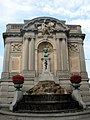
The "Fontaine Ortmans"

Square with buildings from different eras

Saint-Remacle Church in Verviers


Amay | Amel | Ans | Anthisnes | Aubel | Awans | Aywaille | Baelen | Bassenge | Berloz | Beyne-Heusay | Blegny | Braives | Büllingen | Burdinne | Burg-Reuland | Bütgenbach | Chaudfontaine | Clavier | Comblain-au-Pont | Crisnée | Dalhem | Dison | Donceel | Engis | Esneux | Eupen | Faimes | Ferrières | Fexhe-le-Haut-Clocher | Flémalle | Fléron | Geer | Grâce-Hollogne | Hamoir | Hannut | Héron | Herstal | Herve | Huy | Jalhay | Juprelle | Kelmis | Liege | Lierneux | Limbourg | Lincent | Lontzen | Malmedy | Marchin | Modave | Nandrin | Neupré | Olne | Oreye | Ouffet | Oupeye | Pepinster | Plombières | Raeren | Remicourt | Saint-Georges-sur-Meuse | Saint-Nicolas | Saint Vith | Seraing | Soumagne | Spa | Sprimont | Stavelot | Stoumont | Theux | Thimister-Clermont | Tinlot | Trois-Ponts | Trooz | Verlaine | Verviers | Villers-le-Bouillet | Visé | Bug | Waremme | Watery | Weismes | Welkenraedt