
Pepinster
| Pepinster | |||
|---|---|---|---|

|

|
||
|
|||
| State : |
|
||
| Region : | Wallonia | ||
| Province : | Liege | ||
| District : | Verviers | ||
| Coordinates : | 50 ° 34 ' N , 5 ° 48' E | ||
| Area : | 24.79 km² | ||
| Residents: | 9772 (Jan 1, 2019) | ||
| Population density: | 394 inhabitants per km² | ||
| Post Code: | 4860 (Pepinster, Cornesse, Wegnez) 4861 ( Soiron ) |
||
| Prefix: | 087 | ||
| Mayor: | Philippe Godin | ||
Local government address : |
Administration communale Rue Neuve, 35 4860 Pepinster |
||
| Website: | www.pepinster.be | ||

Pepinster is a municipality in the province of Liege in the Walloon Region in Belgium . It lies on the Weser , which flows into the Ourthe , and is about 35 km southwest of Aachen . It belongs to the Euregio Meuse-Rhine . The population is 9772 (as of January 1, 2019), the area 24.79 km².
Town twinning
Pepinster maintains a city partnership with the community Avallon in France .
Culture and sights
The Fort Tancremont in the municipality was part of the fortress ring Liege . The small square main block of the fort has been preserved in large parts and can be visited.
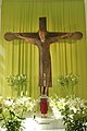
Romanesque cross: Christ of Tancrémont

town hall

church
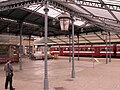
railway station

Weser (Vesdre) near Pepinster

Entrance to Fort Tancremont


traffic
In Pepinster, the line to Spa-Géronstère branches off from the Liège – Aachen line . Intercity trains and regional trains (in Belgium : L ) stop at the station , as well as some intercity trains on the Eupen - Brussels - Ostend line in early and late hours . Aachen Hbf can be reached every hour with the euregioAIXpress .
There are some regional bus routes operated by TEC , among others. a. to Verviers .
Personalities
- Georges Lemaire (1905–1933), racing cyclist
Web links
Amay | Amel | Ans | Anthisnes | Aubel | Awans | Aywaille | Baelen | Bassenge | Berloz | Beyne-Heusay | Blegny | Braives | Büllingen | Burdinne | Burg-Reuland | Bütgenbach | Chaudfontaine | Clavier | Comblain-au-Pont | Crisnée | Dalhem | Dison | Donceel | Engis | Esneux | Eupen | Faimes | Ferrières | Fexhe-le-Haut-Clocher | Flémalle | Fléron | Geer | Grâce-Hollogne | Hamoir | Hannut | Héron | Herstal | Herve | Huy | Jalhay | Juprelle | Kelmis | Liege | Lierneux | Limbourg | Lincent | Lontzen | Malmedy | Marchin | Modave | Nandrin | Neupré | Olne | Oreye | Ouffet | Oupeye | Pepinster | Plombières | Raeren | Remicourt | Saint-Georges-sur-Meuse | Saint-Nicolas | Saint Vith | Seraing | Soumagne | Spa | Sprimont | Stavelot | Stoumont | Theux | Thimister-Clermont | Tinlot | Trois-Ponts | Trooz | Verlaine | Verviers | Villers-le-Bouillet | Visé | Bug | Waremme | Watery | Weismes | Welkenraedt