
Kylltal cycle path
| Kylltal cycle path | |
|---|---|
|
|
|
| overall length | 120 km |
| location | Eifel , Kyll , Moselle / Rhineland-Palatinate |
| map | |
| Link to map and elevation profile | |
| Starting point |
Losheimergraben 50 ° 22 ′ 47 ″ N , 6 ° 20 ′ 33 ″ E |
| Target point |
Trier 49 ° 45 ′ 34.6 ″ N , 6 ° 38 ′ 38 ″ E |
| Places along the way | Stadtkyll , Jünkerath ( Bf ), Birgel , Lissendorf ( Bf ), Gerolstein ( Bf ), St. Thomas ( Bf ), Kyllburg ( Bf ), Erdorf ( Bf ), Auw an der Kyll ( Bf ), Kordel ( Bf ), Ehrang ( Bf ) |
| Flooring | 118 km of asphalt, the rest of the paved roads |
| Height difference | Start 620 m , end 124 m +574 m up / −915 m down |
| difficulty | slightly hilly; on 3 km> 10% gradient |
| Traffic volume | Bike path; seldom roads with little traffic. |
| Connection to | Prümtal-Radweg , Eifel-Ardennen-Radweg , Kalkeifel-Radweg , Nimstal-Radweg , Moselle-Radweg |
| ADFC certification | 4 out of 5 stars |
| Website URL | Kyll cycle path at www.eifel.info |
The Kylltal cycle path (also known as the Kyll cycle path) is a 120 km long cycle path that runs largely parallel to the Kyll . It connects the origin of the Kyll near Losheimergraben on the German- Belgian border with the confluence with the Moselle near Trier-Ehrang and the Roman city of Trier, only a few kilometers away . On the part from Jünkerath to Trier you can drive next to a railway - the Eifel route (also through 2 tunnels), and save yourself a climb. The cycle path crosses several landscapes in the Eifel . The route is asphalted for approx. 118 km, the rest is on paved paths. The uniform signage with the bike path logo is designed in both directions according to the guidelines of the ADFC . Between Gerolstein-Bewingen and Densborn , an almost flat, approx. 20 km long children's cycle path has been set up.
Route source - mouth
Characteristic
The route is almost everywhere flat to slightly hilly. The only exception is a steep climb (> 10%) (approx. 110 meters in altitude) between Kyllburg and Bitburg-Erdorf . However, this section can be bridged by train ( Kyllburg and Erdorf stations ). The separate cycle path from Jünkerath-Glaadt to Densborn is paved. Then the route leads partly on quiet country roads to Bitburg-Erdorf. From there the route runs parallel to the railway line. In two places the cycle path leads through tunnels, separated from the railway by bars , instead of the second dismantled track: The Dechen Tunnel (181 m) is between St. Thomas and Kyllburg. The Kyller Tunnel (138 m) is located 8 km north of Kordel. The condition of the path is consistently good from Frauenkron .
description
The cycle path begins at the confluence of the three source streams of the Kyll on the German-Belgian border, near Losheimergraben , which belongs to the municipality of Hellenthal in North Rhine-Westphalia . The first few kilometers lead through a hilly forest area, leaving the state of North Rhine-Westphalia. The first village that is reached after the forest is Frauenkron , a district of Dahlem . The cycle path then follows the L22 for about one kilometer and reaches the Kronenburger See , where the Kyll is dammed in a flood retention basin. The route leads past the northern bank of the lake, which is used as a recreational and recreational lake. Only a few kilometers to the north are the town and castle ruins of Kronenburg with their interesting history. The route then runs via Kronenburgerhütte to Stadtkyll . Here the Prümtal cycle path branches off, which leads over the headwaters, along the river, to its mouth in the Sauer near Minden . Then the place Jünkerath is reached.
On May 3, 2015, after the completion of the conversion of the former route of the Vennquerbahn to a walkway and cycle path, the final new section from Jünkerath to the Belgian border was opened. There is now a mostly paved stretch from Weywertz on the route of the former railway (RAVel L.45a) via Losheimergraben (border) and seamlessly into the Kyll cycle path to Jünkerath, which then continues as the Kylltal cycle path to Trier. In Weywertz there is a connection to the Vennbahnradweg .
The first train station is located in Jünkerath, directly on the bike path. The route continues via Gönnersdorf to Birgel . The next place on the Kylltal cycle path is Bolsdorf, a district of Hillesheim, where the Kalkeifel cycle path ends after a route through the "Bolsdorfer Tälchen". The castle ruins of Kasselburg are visible from afar in front of Gerolstein . Gerolstein announces itself through the Dolomite massif , the remains of a former coral reef. The Eifel-Ardennes Cycle Path also runs through Gerolstein , which, together with its connecting paths, crosses the Eifel in a west-east direction.
After Gerolstein the next place is Birresborn . The cycle path then continues to the Eifel village of Mürlenbach , where the Bertradaburg stands. The great-grandmother of Charlemagne is considered to be the founder of the castle and Charlemagne is said to be born there. Close to Kyll and the railway, the route then continues through the towns of Densborn and Usch-Zendscheid to medieval Kyllburg with Malberg Castle and Kyllburg Castle . After Kyllburg, the path leaves the Kyll and leads over a gradient of up to 13% up a hill, with a subsequent descent to Bitburg-Erdorf , where the path meets the Kyll again. A total of around 110 meters difference in altitude has to be mastered.
The route leads via Hüttingen an der Kyll and Philippsheim to the pottery village of Speicher . From Auw an der Kyll , where the pilgrimage church Maria Himmelfahrt is located, to the Moselle, the path leads through the meadow-like landscape with lush bank vegetation. Behind the village of Kordel , Ramstein Castle, the last Eifel castle is passed before the confluence of the Kyll and the Moselle in Trier-Ehrang . You can continue to ride or hike via the Moselle cycle path via Trier-Pfalzel to Trier-Mitte.
Elevation profile
| kilometre | section | Length / km | + Hm up + Hm down |
|---|---|---|---|
| 0 | Losheimergraben - Hallschlag | 15th | ? |
| 15th | Hallschlag - Jünkerath | 13 | +41 / −115 |
| 28 | Jünkerath - Hillesheim-Bolsdorf | 11 | +87 / −97 |
| 39 | Hillesheim-Bolsdorf - Gerolstein | 10 | +57 / −104 |
| 49 | Gerolstein - Densborn | 15th | +23 / -67 |
| 54 | Densborn - Kyllburg | 11 | +25 / −59 |
| 75 | Kyllburg - Erdorf | 6th | +146 / −186 |
| 81 | Erdorf - Hüttingen | 6th | +87 / −98 |
| 87 | Hüttingen - Speicher (train station) | 9 | +13 / -60 |
| 96 | Speicher (train station) - cord | 15th | +82 / −98 |
| 111 | Cord - Ehrang | 8th | +14 / −26 |
| 119 | Ehrang - Trier | 11 | +11 / −4 |
| 130 | trier | - |
Landscape and culture

View of Stadtkyll
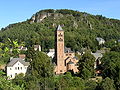
Church of the Redeemer in Gerolstein

Lissingen Castle near Gerolstein

Route next to the railroad track in the Kyller Tunnel

Kyll shortly before the confluence with the Moselle
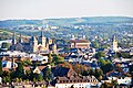
Trier city center


The Kyll forms in the Zitterwald from three source streams near Losheimergraben on the German- Belgian border. One of the source streams rises in the Belgian part of the village of Losheimergraben, in the basement of the Schröders Hotel. The first kilometers the Kyll flows through the state of North Rhine-Westphalia . It then reaches the area of the federal state of Rhineland-Palatinate, which it does not leave until it flows into the Moselle. In the upper part, the Kylltal forms the natural border between Zitterwald and the Schnee Eifel to the south . Seen from the source, the cycle route initially leads through the northern Eifel with its dams and lakes. Then it reaches the volcanic Eifel, which is shaped by the elemental forces, and finally the southern Eifel with its typical orchard meadows and rugged rock formations of the Bitburger Gutland . In the lower reaches it impresses with an almost untouched meadow landscape.
Attractions
- Kronenburg : The place with its castle ruins and the reservoir that was created as a flood retention basin of the Kyll and serves as a recreational and recreational water .
- Jünkerath : The Jünkerath Iron Museum documents the history of the Eifel iron industry since the 15th century.
- Birgel : Historic water mill with cutting, oil and mustard mill and schnapps distillery.
- Hillesheim : Hillesheim has a historic town center and a well-preserved and restored city wall from the 13th century. The city wall is accessible via a battlement.
- Gerolstein : The Kasselburg with the "Adler- und Wolfspark Kasselburg", where free flight exercises of golden eagles and falcons are shown. The Church of the Redeemer , which was a gift from the Berlin Church Building Association to Kaiser Wilhelm II . The Löwenburg and Lissingen Castle and the Roman "Villa Sarabodis" . The natural history museum in the old town hall shows the turbulent geological past of the region.
- Mürlenbach : Bertradaburg .
- Kyllburg : With the Malberg Castle , which wasexpanded in the Venetian Baroque, the collegiate church and Kyllburg Castle . In the district of St. Thomas the former Cistercian monastery of the same name.
- Speicher : Here clay is still burned with the largest and oldest wood-burning stove in Germany, while the local history museum provides information about the history of pottery in the region.
- Auw an der Kyll : Pilgrimage Church of the Assumption of Mary .
- Trier : The city was founded more than 2000 years ago and claims the title of the oldest city in Germany . The Roman monuments in Trier , consisting of amphitheater , Barbara Baths , Imperial Baths , Constantine Basilica , Porta Nigra , Roman Bridge , Igel Column , Cathedral and the Church of Our Lady count since 1986 UNESCO - World Heritage Site .

Connecting cycle paths
From Losheimergraben on the route of the former Vennquerbahn via Büllingen to Weywertz to the Vennbahnradweg . From Bolsdorf, a district of Hillesheim, the Kalkeifel cycle path leads as a rail route to Ahrdorf in the Ahr valley . From the Kalkeifel cycle path, the mineral spring route branches off in Niederehe and connects to the Maare-Mosel cycle path via Daun . For Maare-Moselle bicycle route, there is another cross-connection to Wittlich , over just a few kilometers down the Moselle in Schweich starting Wittlicher bike path sink . In Gerolstein there is a connection to the Eifel-Ardennen cycle path that connects St. Vith in Belgium and Adenau at the Nürburgring . Together with the connecting paths, there is thus a cycling route that crosses the entire Eifel in a north-easterly direction. With the connection to the Moselle cycle path, the course of the Moselle between Metz and Koblenz is accessible via cycle paths.
See also:
Train and bus connections
The train station closest to the Kyll-Ursprung is Dahlem on the Eifel route Cologne - Trier or Koblenz. It is approx. 10 km from here to Kronenburg and approx. 23 km to the source of the Kyll near Losheimergraben. The connection from Dahlem to Kronenburg is signposted as a valley route .
If you choose the route directly towards the mouth, you can reach Jünkerath in approx. 6 km. Then the Jünkerath train station, as the next station on the Eifel route, is a good starting point. The Eifel route then runs alongside the route to Trier. In Trier there is also a connection to the Moselle route to Koblenz, which is served every hour.
On the Kaisersesch - Daun - Gerolstein line of the former Eifelquerbahn , rail buses and reconditioned passenger trains of the Vulkan-Eifel-Bahn (VEB) operated from 2000 to 2012 . The two-hour operation was limited to the season from May to October on weekends and holidays. A resumption of traffic is currently being discussed, but is controversial due to the high renovation costs (as of May 2015).
The “ Regioradler Vulkaneifel ” RegioLine 500 bus line runs daily from April 1st to November 1st between Cochem on the Moselle and Gerolstein in the Vulkaneifel and also connects Ulmen and Daun on the way. This bus line has space for 22 bicycles.
literature
- ADFC regional map Eifel / Mosel. 1: 75,000. 1st edition. Bielefelder Verlag, 2006, ISBN 3-87073-391-8 .
- Cycling atlas Cycling atlas "South Eifel" - between the Ardennes and the Vulkaneifel. 1: 75,000. Verlag Esterbauer, ISBN 978-3-85000-269-1 .
Web links
swell
- Radwanderland.de Retrieved November 2011
Individual evidence
- ↑ Kyll-Radweg (on adfc-tourenportal.de) ( Memento from February 5, 2018 in the Internet Archive )
- ↑ Kyll cycle path at www.eifel.info
- ↑ Children's cycle path , accessed on February 4, 2018
- ↑ Children's cycle path in the Eifel at www.adfc.de, accessed on February 4, 2018
- ↑ The route of the Vennquerbahn Kyll cycle path between Jünkerath and Losheim is released Kölner Stadt-Anzeiger from April 29, 2015, accessed on February 4, 2018
- ↑ The Kylltal cycle path on the former Jünkerath - Weywertz Eifelzeitung railway from May 3, 2015, accessed on February 4, 2018
- ↑ RegioRadler Vulkaneifel , accessed on February 4, 2018