Birgel
| coat of arms | Germany map | |
|---|---|---|

|
Coordinates: 50 ° 19 ′ N , 6 ° 37 ′ E |
|
| Basic data | ||
| State : | Rhineland-Palatinate | |
| County : | Vulkaneifel | |
| Association municipality : | Gerolstein | |
| Height : | 420 m above sea level NHN | |
| Area : | 6.52 km 2 | |
| Residents: | 449 (Dec. 31, 2019) | |
| Population density : | 69 inhabitants per km 2 | |
| Postal code : | 54587 | |
| Area code : | 06597 | |
| License plate : | DAU | |
| Community key : | 07 2 33 007 | |
| Association administration address: | Kyllweg 1 54568 Gerolstein |
|
| Website : | ||
| Local Mayor : | Elmar Malburg | |
| Location of the local community Birgel in the Vulkaneifel district | ||
Birgel is a municipality in the Vulkaneifel district in Rhineland-Palatinate . It belongs to the Gerolstein community .
geography
Geographical location
The place is located in the Vulkaneifel nature park on the upper Kyll . Birgel is halfway between Trier and Cologne . It is accessed via the B 421 and the Cologne - Trier railway line ( Lissendorf station ).
Birgel also includes the Bielenhof, Haus Müllers, Haus Papillon, Tannenhof and Hubertushof residential areas .
geology
The place naturally belongs to the Kalkeifel and lies on the southern edge of the Dollendorfer Kalkmulde . The altitude extends from about 400 m above sea level. NHN on the Kyll near Crumpsmühle up to about 526 m above sea level. NHN am Hirzberg .
Geologically, three formations shape the community. The foothills of the Central Devonian limestone basin in the north, the red sandstone in the center and in the east, and the sediments of the Kyll in the west.
As a result, there are larger sources of groundwater , which not only supply Birgel, but also other places in the community of Obere Kyll with drinking water.
Geological and natural history features
- Red sandstone rock , natural monument in the Birgeler Hardt
- Lime kiln (former limestone quarry on Hirschberg)
- Butterlei , natural monument ( dolomite rocks on the Hirschberg)
- Kylltalaue
- Wiesbach with Wiesbachmoor and arnica meadow
- Castle hill with Celtic hilltop settlement and former sand pits
history
The first documented mention of Birgel can be found in the commentary on the Prümer Urbar from 1222. In 1457, Gerhard von Loen , Count von Blankenheim, acquired half of a farm in Birgel. The Lords of Mirbach also had ownership rights in the place, as they referred to themselves as "Lords of Birgel" in a document from the 16th century. In the 16th century, Birgel came under the control of the Counts of Gerolstein . The elector of Trier owned a fiefdom in the village . The electoral trier bailiff zu Daun received pensions from Birgel in the 16th century. However, the Counts of Manderscheid-Blankenheim-Gerolstein remained dominant in the place . On the occasion of a comparison in 1547 it was determined that Birgel belonged to the Gerolstein lordship.
In the so-called French era , Birgel belonged to the canton of Lissendorf in the Saardepartement from 1798 to 1814 . Under the subsequent Prussian administration, Birgel was assigned to the mayor's office in Lissendorf in the Daun district ( Trier administrative district ).
With the Rhineland-Palatinate municipal reform in 1970, the formerly independent offices of Stadtkyll and Lissendorf-Birgel were dissolved and the municipality of Birgel was incorporated into the newly formed community of Obere Kyll , based in Jünkerath .
- Population development
The development of the population of Birgel, the values from 1871 to 1987 are based on censuses:
|
|
politics
Municipal council
The municipal council in Birgel consists of eight council members, who were elected by a majority vote in the local elections on May 26, 2019 , and the honorary local mayor as chairman.
coat of arms
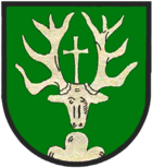
| Blazon : "In green over a silver three-mountain, a silver deer head in the visor with a silver high cross between the antlers." | |
| Justification of the coat of arms: The place name goes back to an Old High German name for a small mountain. The Dreiberg in the coat of arms of the local community stands as a talking coat of arms for Birgel. The silver deer head with cross is the attribute of Saint Hubertus , to whom the chapel in Birgel is consecrated. |
Culture and sights
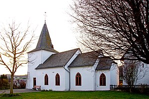
- Chapel St. Hubertus - a hall building from the early 16th century.
- Butterley - a dolomite rock on the Hirschberg, which has been a natural monument since 1938.
- Birgeler Hardt - the red sandstone cliffs have been a natural monument since 1948.
- Hubertus oak from 1750 - it is 23 m high and has a chest height of 2.5 m.
- Historic water mill from the 13th century with a mill museum.
- Pilgrim stone from 1997 between Wiesbaum and Birgel.
See also: List of cultural monuments in Birgel
See also: List of natural monuments in Birgel
Public facilities
- Community center
- Fire station
- Chapel , the Hubertus consecrated
- Cemetery with a burial hall
- Sports field with barbecue hut and multi-purpose hall
- near-natural playground with football field (inauguration 2006)
Others
In 2006 the local community Birgel achieved 1st place in the competition Our village has a future in the main class of the Vulkaneifel district (at that time still Daun district).
literature
- Ernst Wackenroder (arrangement): The art monuments of the Daun district (= Paul Clemen [Hrsg.]: The art monuments of the Rhine province . Volume 12 / III ). Trier 1983, ISBN 3-88915-005-5 , p. 150–152 (271 p., With 12 plates, 2 overview maps and 171 illustrations in the text. Reprinted by the Schwann edition, Düsseldorf 1928).
- Gerten, Wisniewski, Höster: The Kyll story and stories about an Eifel watercourse. Ed .: Bernd Spindler, Verbandsgemeinde Kyllburg, October 2006.
- Hubert Pitzen: The Kurtrierischer Hof in Birgel in the 17th and 18th centuries. In: Heimat-Jahrbuch des Landkreis Daun. 1996, pp. 91-93.
Web links
- Internet presence of the local community Birgel
- Local community Birgel on the website of the Verbandsgemeinde Obere Kyll
- To search for cultural assets of the local community Birgel in the database of cultural assets in the Trier region .
- Willi Steffens: The old mill law in the Eifel . In: Heimatjahrbuch 1976. Weiss-Verlag, Daun 1976, p. 61. (online at : jahrbuch-daun.de/ )
Individual evidence
- ↑ State Statistical Office of Rhineland-Palatinate - population status 2019, districts, communities, association communities ( help on this ).
- ↑ State Statistical Office Rhineland-Palatinate (ed.): Official directory of the municipalities and parts of the municipality. Status: January 2018 [ Version 2020 is available. ] . S. 74 (PDF; 2.2 MB).
- ↑ See Hubert Pitzen: The Kurtrierischer Hof in Birgel in the 17th and 18th centuries. In: Heimat-Jahrbuch des Landkreis Daun. 1996, pp. 91-93.
- ↑ Gerten, Höser, Wisniewski: The Kyll. 2006.
- ↑ State Statistical Office Rhineland-Palatinate - regional data
- ^ The Regional Returning Officer Rhineland-Palatinate: Local elections 2019, city and municipal council elections
- ↑ Birgel's coat of arms. Retrieved March 20, 2017 .


