Steineberg
| coat of arms | Germany map | |
|---|---|---|

|
Coordinates: 50 ° 11 ′ N , 6 ° 55 ′ E |
|
| Basic data | ||
| State : | Rhineland-Palatinate | |
| County : | Vulkaneifel | |
| Association municipality : | Down | |
| Height : | 525 m above sea level NHN | |
| Area : | 2.93 km 2 | |
| Residents: | 206 (Dec. 31, 2019) | |
| Population density : | 70 inhabitants per km 2 | |
| Postal code : | 54552 | |
| Area code : | 06573 | |
| License plate : | DAU | |
| Community key : | 07 2 33 067 | |
| Association administration address: | Leopoldstrasse 29 54550 Daun |
|
| Website : | ||
| Local Mayor : | Harald Dahlem | |
| Location of the local community of Steineberg in the Vulkaneifel district | ||
Steineberg is a municipality in the Vulkaneifel district in Rhineland-Palatinate . She belongs to the community of Daun .
The small town, a bit away from the Dauner Maare in the Vulkaneifel , is actually a typical street village . In the last few decades, and especially since the 1970s, the place has expanded. New building areas have been designated. Today 240 inhabitants live along the four streets in the village.
geography
Spatial location
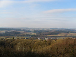
Steineberg is located in the Vulkaneifel, south of the Hohen Eifel , about 20 km north of the Moselle valley near the district town of Daun . The center of the village is at 530 m above sea level. NN . The highest point at 557 m above sea level. NN is the Steineberger Ley . The community area comprises 124 hectares of forest and 169 hectares of arable land and meadows.
Neighboring communities
The local community of Steineberg borders in the north on the community Steiningen , in the east on the community Demerath , in the south on the community Ellscheid and in the west on Mehren .
history
Wonderfully country belonged Steineberg by the end of the 18th century to the Electorate of Trier and shelter as part of the centering Steiningen the high court down the administration of the office down . In 1787, Steineberg had 105 inhabitants.
- Population development
The development of the population of Steineberg, the values from 1871 to 1987 are based on censuses:
|
|
Municipal council
The municipal council in Steineberg consists of six council members, who were elected by a majority vote in the local elections on May 26, 2019 , and the honorary local mayor as chairman.
Culture and sights
Steineberger Ley
The most outstanding, in the truest sense of the word, is the so-called Steineberger Ley ( 557 m above sea level ). This mountain, visible from afar, on the southeastern outskirts of Steineberg, which extends to the lower, northern neighboring municipality of Steiningen , is of touristic and historical importance. Many legends and historical events entwine around the densely forested mountain in Steineberg and the surrounding area.
The mountain has its origin in the lively volcanism of the Eifel around 35 million years ago in the Tertiary era . At that time, Steineberg was in a north-south strip that was subject to particular volcanic activity. As a result of these forces of nature, a solid basalt stone forms the subsoil of the Steineberger Ley.
The word “Ley” occurs more frequently in the Eifel region and in this case indicates the nature of the mountain, because it means rock, slate . It is also obvious that the mountain was once the reason for the name of the village of Steineberg.
Vulcano information platform
On October 3rd, 2003 the Vulcano information platform of the local parish of Steineberg was opened on the Steineberger Ley. The 28 m high tower was built with the help of funds from the European Union , the State of Rhineland-Palatinate , the Daun community and the Daun / Vulkaneifel economic development company. From an ecological point of view, the structure was made from untreated Douglas fir trunks that are over 100 years old and, with a total weight of 38 t, carries the viewing platform at a height of 24 m.
Due to the excellent location above the treetops of the Steineberger Ley, with good visibility you can see far over the Eifel and the Moselle valleys and even see the Nürburgring , about 20 km away .
Celtic ring wall
The basalt dome of the Steineberger Ley has an old fortification on its southern end . Crumbling walls made of stones placed without mortar and artificially steep edges line a gently sloping inner surface of 2.2 hectares . Especially at the north end it is difficult to differentiate between natural weathering heaps and artificial walls. An old gate system can be assumed due to the clearly offset wall ends on the south side.
Since no archaeological investigations have yet taken place, the age of the fortifications can only be estimated in comparison: the size of the area and the construction of the wall made of dry-joined stones (probably with a timber framework ) speak for a Celtic castle from around 500 or 300 - 100 BC The times mentioned above, similar castles were built everywhere in the low mountain range as demonstrative, defensive bases for rival lords.
A few finds come from the late Celtic (1st century BC) and late Roman times (4th century AD), but they do not yet allow any statements about the reasons for visiting the mountain. In front of the southern foot of the mountain there is an early Celtic barrow field (6th – 3rd century BC). Many of the approximately 90 hills that were excavated many times in the 19th century are still recognizable. Castle and barrows are protected cultural monuments , excavations and changes of any kind are therefore prohibited.
Economy and Infrastructure
economy
The place itself is dominated by agriculture , even if today only two farms with predominantly dairy farming and slaughter cattle (sheep) are managed. Even in the time before the First World War , many Steinebergers were working in a basalt-lava quarry on the edge of the Steineberger Ley . Since this is located in the immediate vicinity of the historic ring wall on the Ley, consideration was given to closing the quarry as early as the 1950s. The closure was finally completed in 1967, the quarry was transformed into a wetland habitat from 1976 , and in 1983 the Steineberger Ley was declared an official and therefore protected natural monument.
Today the majority of the Steinebergers work in service companies and industrial companies all over the Eifel , mainly in Daun . Long commutes to work and shopping are not part of everyday life here.
traffic
Steineberg is in the immediate vicinity of the A 1 and A 48 motorways , southeast of the Vulkaneifel motorway triangle . It is only a few kilometers to the next Daun-Mehren motorway exit . The B 421 runs south along the municipal boundary. The nearest train station is in Gerolstein, over 20 km away . Steineberg can be reached by bus with line 503 from Daun .
See also
- Steineberg (Westerwald) is a district of the municipality of Malberg (Westerwald) .
- List of cultural monuments in Steineberg
Web links
- Internet presence of the local parish of Steineberg
- To search for cultural assets of the local community of Steineberg in the database of cultural assets in the Trier region .
- Vulcano information platform
- Film about Steineberg in Hierzuland , SWR television
Individual evidence
- ↑ State Statistical Office of Rhineland-Palatinate - population status 2019, districts, communities, association communities ( help on this ).
- ^ Wilhelm Fabricius : Explanations of the historical atlas of the Rhine province, Volume 2: The map of 1789. Bonn 1898, p. 112, 149.
- ↑ State Statistical Office Rhineland-Palatinate - regional data
- ^ The Regional Returning Officer Rhineland-Palatinate: Local elections 2019, city and municipal council elections
- ↑ http://www.landesmuseum-trier.de/ Rheinisches Landesmuseum Trier


