
Schalkenmehren
| coat of arms | Germany map | |
|---|---|---|

|
Coordinates: 50 ° 10 ′ N , 6 ° 52 ′ E |
|
| Basic data | ||
| State : | Rhineland-Palatinate | |
| County : | Vulkaneifel | |
| Association municipality : | Down | |
| Height : | 425 m above sea level NHN | |
| Area : | 10.4 km 2 | |
| Residents: | 587 (Dec. 31, 2019) | |
| Population density : | 56 inhabitants per km 2 | |
| Postal code : | 54552 | |
| Area code : | 06592 | |
| License plate : | DAU | |
| Community key : | 07 2 33 063 | |
| Association administration address: | Leopoldstrasse 29 54550 Daun |
|
| Website : | ||
| Local Mayor : | Peter Hartogh | |
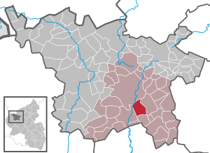
| Location of the municipality of Schalkenmehren in the Vulkaneifel district | ||
  |
||


Schalkenmehren is a municipality in the Vulkaneifel district in Rhineland-Palatinate . She belongs to the community of Daun . Schalkenmehren is a state-approved resort .
geography
The municipality of Schalkenmehren is located in the Vulkaneifel around 4 km (as the crow flies ) south-southeast of Daun at the northeast foot of the Hohen List . Several volcanic lakes , such as the Schalkenmehrener Maar , the Weinfelder Maar and the Gemündener Maar , are also located in the district, as is the ski area (with lift) on the Mäuseberg.
The Schalkenmehrener Maar is a popular bathing lake.
Schalkenmehren also includes the Altburg, Bahnhof, Barninerhof, Bintener Hof, Former Flakhaus, Hoher List observatory and Schalkenmehrener Mühle residential areas .
history
The first mention of the community was on November 25, 1287 in a document issued for the Himmerod monastery .
Until the end of the 18th century, Schalkenmehren belonged to the Electorate of Trier and was under the administration and jurisdiction of the Daun office . Schalkenmehren was the seat of a center . Ecclesiastically, Schalkenmehren belonged to the Archdiocese of Cologne .
In 1794 the Left Bank of the Rhine was occupied by French revolutionary troops in the First Coalition War. From 1798 to 1814, Schalkenmehren belonged to the canton of Daun in the Saar department .
At the Congress of Vienna (1815), the region came to the Kingdom of Prussia , Schalkenmehren in 1816 the newly built district down in Trier assigned by the and mayor Daun managed.
After the Second World War , the municipality of Schalkenmehren became part of the then newly formed state of Rhineland-Palatinate within the French occupation zone .
Home weaving cooperative
In 1920 the young teacher Anna Droste-Lehnert came to the Eifel village. She noticed that the Eifel farmers were very poor and that they could weave very beautiful fabrics, the so-called "Maartuch". With friends from the Wandervogel movement , she convinced the population to set up a cooperative with her. In 1926, 19 residents of Schalkenmehren joined forces to form the Schalkenmehren eG Heimweberei-Genossenschaft . The farmers wove, the women tailors, and the cooperative marketed the products. Mrs. Droste-Lehnert also designed new patterns for the weavers. The cooperative was very successful in the 1930s, and it proved its worth even in the difficult post-war period.
In the 1970s, a contribution to the program was shot over the cooperative with the mouse . After there were fewer and fewer farmers in the village, and even less active weavers, the cooperative was dissolved in 1983.
Active citizens of the community of Schalkenmehren later founded the home weaving museum Schalkenmehren , in which the history of the home weaving cooperative is presented, and run it on a voluntary basis.
Population development
The development of the population of Schalkenmehren, the values from 1871 to 1987 are based on censuses:
|
|
politics
Municipal council
The local council in Schalkenmehren consists of eleven council members, who were elected in a majority vote in the local elections on May 26, 2019 , and the honorary local mayor as chairman.
Economy and Infrastructure


Schalkenmehren has a small airfield for motor planes and gliders, an observatory that belongs to the University of Bonn , and the Schalkenmehren home weaving museum .
With the founding date of November 11, 1868, the Hotel Schneider am Maar is the most traditional restaurant, which is now in the sixth generation of the family.
The addiction clinic in Altburg near Schalkenmehren has been working with a success rate of up to 50% since 1991.
- Schalkenmehren

View of Schalkenmehren and the Schalkenmehrener Maar
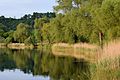
Evening mood on the maar

Schalkenmehren

Town center

Old tools on a farm house
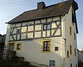
former farmhouse Haus Hinneres (1742), today holiday apartments


traffic
On December 1st, 1909, Schalkenmehren was connected to the rail network with the opening of the Maare-Mosel-Bahn . Since May 29, 1988, Schalkenmehren can no longer be reached by train. The Maare-Mosel cycle path now runs along the former railway line .
See also
Web links
- Website of the local community of Schalkenmehren
- The Schalkenmehrener Maare ( Memento from March 9, 2012 in the web archive archive.today )
- To search for cultural assets of the local community of Schalkenmehren in the database of cultural assets in the Trier region .
- Home weaving museum
Individual evidence
- ↑ a b State Statistical Office of Rhineland-Palatinate - population status 2019, districts, municipalities, association communities ( help on this ).
- ↑ a b State Statistical Office Rhineland-Palatinate - regional data
- ↑ State Statistical Office Rhineland-Palatinate (ed.): Official directory of the municipalities and parts of the municipality. Status: January 1, 2017 [ Version 2020 is available. ] . S. 70 (PDF; 1.9 MB).
- ↑ Sarah-Lena Gombert: 4000 chances of returning to a normal life. In: Trierischer Volksfreund , November 15, 2011, accessed on June 16, 2015.

Arbach | Basberg | Beinhausen | Bereborn | Berenbach | Berlingen | Berndorf | Betteldorf | Birgel | Birresborn | Bleckhausen | Bodenbach | Bongard | Borler | Boxberg | Brockscheid | Brückal | Darscheid | Down | Demerath | Densborn | Deudesfeld | Dockweiler | Dohm-Lammersdorf | Drees | Dreis-Brück | Duppach | Ellscheid | Esch | Feusdorf | Gefell | Gelenberg | Gerolstein | Gillenfeld | Gönnersdorf | Gunderath | Reverberation | Hillesheim | Hinterweiler | Höchstberg | Hohenfels-Essingen | Horperath | Hörscheid | Hörschhausen | Immerath | Jünkerath | Kalenborn scrubbing | Caperich | Katzwinkel | Kelberg | Kerpen (Eifel) | Kerschenbach | Kirchweiler | Kirsbach | Kolverath | Kopp | Kötterichen | Kradenbach | Lirstal | Lissendorf | Mannebach | More | Meisburg | Mosbruch | Mosquitoes | Mürlenbach | Neichen | Nerd | Neroth | Niederstadtfeld | Nitz | Nohn | Oberbettingen | Oberehe-Stroheich | Oberelz | Oberstadtfeld | Ormont | Pelm | Reimerath | Retterath | Reuth | Rockeskyll | Salm | Sarmersbach | Sassen | Saxler | Schalkenmehren | Scheid | Schönbach | Schüller | Protection | Stadtkyll | Steffeln | Steineberg | Steiningen | Strohn | Strotzbüsch | Üdersdorf | Udler | Uersfeld | Ueß | Utzerath | Üxheim | Wallenborn | Walsdorf | Weidenbach | Which council | Wiesbaum | Winkel (Eifel)