
Reimerath
| coat of arms | Germany map | |
|---|---|---|

|
Coordinates: 50 ° 19 ′ N , 6 ° 58 ′ E |
|
| Basic data | ||
| State : | Rhineland-Palatinate | |
| County : | Vulkaneifel | |
| Association municipality : | Kelberg | |
| Height : | 530 m above sea level NHN | |
| Area : | 2.54 km 2 | |
| Residents: | 58 (Dec. 31, 2019) | |
| Population density : | 23 inhabitants per km 2 | |
| Postal code : | 53539 | |
| Area code : | 02692 | |
| License plate : | DAU | |
| Community key : | 07 2 33 233 | |
| LOCODE : | DE REA | |
| Community structure: | 2 districts | |
| Association administration address: | Dauner Strasse 22 53539 Kelberg |
|
| Website : | ||
| Local Mayor : | Matthias Schneider | |
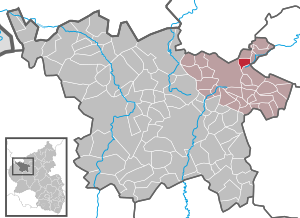
| Location of the local community Reimerath in the Vulkaneifel district | ||
  |
||

Reimerath is a municipality in the Vulkaneifel district in Rhineland-Palatinate . It belongs to the association community Kelberg .
geography
It is located in the Vulkaneifel Nature Park and the conservation area "Kelberg". The community is divided into the districts of Reimerath and Bruchhausen.
history
Reimerath was first mentioned as "Recinroth" in a document dated May 25, 1216, when Count Gerhard von Are of the parish church in Adenau confirmed the foundation of his father Ulrich's Anniversar . The Bruchhausen district was mentioned in 1409.
Reimerath belonged to the late 18th century to the office of mayor Welcherath the Electoral Cologne Office Nürburg .
In 1794 French revolutionary troops occupied the left bank of the Rhine . Under the French administration , Reimerath belonged to the canton of Adenau in the Rhine-Moselle department from 1798 to 1814 . Due to the agreements made at the Congress of Vienna in 1815 , the region became part of the Kingdom of Prussia . Under Prussian administration, the municipality of Reimerath was assigned to the Adenau district in the Koblenz administrative district and was administered by the Kelberg mayor . This went on in 1927 in the Kelberg office and in 1968 in the Kelberg Association. After the First World War , the area was under French military administration . When the Adenau district was dissolved in 1932, Reimerath came to the Mayen district . The region has been part of the state of Rhineland-Palatinate since 1946 and belonged to the French occupation zone until 1949 and 1955, respectively .
As part of the municipal reorganization of Rhineland-Palatinate, the community came on November 7, 1970 from the district of Mayen , which was dissolved at the same time, to the district of Daun (now the district of Vulkaneifel ).
In Reimerath there is an old quarry where trachyte was previously extracted.
- Population development
The development of the population of Reimerath, the values from 1871 to 1987 are based on censuses:
|
|
politics
Municipal council
The municipal council in Reimerath consists of six council members, who were elected by a majority vote in the local elections on May 26, 2019 , and the honorary local mayor as chairman.
coat of arms
|
|
Blazon : "Under a silver shield head with a black bar cross in blue a wreath of golden roses with silver lugs." |
| Explanation of the coat of arms: The black bar cross indicates the earlier membership in the Electorate of Cologne ; the wreath of roses symbolizes the patronage of the rosary queen , to whom the Reimerath chapel is consecrated. |
See also
Web links
- Internet presence of the local community Reimerath
- Reimerath community on the website of the Kelberg community community
- To search for cultural goods belonging to the Reimerath community in the database of cultural goods in the Trier region .
Individual evidence
- ↑ State Statistical Office of Rhineland-Palatinate - population status 2019, districts, communities, association communities ( help on this ).
- ↑ State Statistical Office Rhineland-Palatinate (ed.): Official directory of the municipalities and parts of the municipality. Status: January 2018 [ Version 2020 is available. ] . S. 73 (PDF; 2.2 MB).
- ↑ Heinrich Beyer , Leopold Eltester, Adam Goerz: Document book for the history of the Middle Rhine territories: From the years 1212 to 1260. Volume 3. Hölscher, Coblenz 1874, p. 53 ( online ).
- ↑ Official municipality directory (= State Statistical Office of Rhineland-Palatinate [Hrsg.]: Statistical volumes . Volume 407 ). Bad Ems February 2016, p. 156 (PDF; 2.8 MB).
- ↑ State Statistical Office Rhineland-Palatinate - regional data
- ^ The Regional Returning Officer Rhineland-Palatinate: Local elections 2019, city and municipal council elections

Arbach | Basberg | Beinhausen | Bereborn | Berenbach | Berlingen | Berndorf | Betteldorf | Birgel | Birresborn | Bleckhausen | Bodenbach | Bongard | Borler | Boxberg | Brockscheid | Brückal | Darscheid | Down | Demerath | Densborn | Deudesfeld | Dockweiler | Dohm-Lammersdorf | Drees | Dreis-Brück | Duppach | Ellscheid | Esch | Feusdorf | Gefell | Gelenberg | Gerolstein | Gillenfeld | Gönnersdorf | Gunderath | Reverberation | Hillesheim | Hinterweiler | Höchstberg | Hohenfels-Essingen | Horperath | Hörscheid | Hörschhausen | Immerath | Jünkerath | Kalenborn scrubbing | Caperich | Katzwinkel | Kelberg | Kerpen (Eifel) | Kerschenbach | Kirchweiler | Kirsbach | Kolverath | Kopp | Kötterichen | Kradenbach | Lirstal | Lissendorf | Mannebach | More | Meisburg | Mosbruch | Mosquitoes | Mürlenbach | Neichen | Nerd | Neroth | Niederstadtfeld | Nitz | Nohn | Oberbettingen | Oberehe-Stroheich | Oberelz | Oberstadtfeld | Ormont | Pelm | Reimerath | Retterath | Reuth | Rockeskyll | Salm | Sarmersbach | Sassen | Saxler | Schalkenmehren | Scheid | Schönbach | Schüller | Protection | Stadtkyll | Steffeln | Steineberg | Steiningen | Strohn | Strotzbüsch | Üdersdorf | Udler | Uersfeld | Ueß | Utzerath | Üxheim | Wallenborn | Walsdorf | Weidenbach | Which council | Wiesbaum | Winkel (Eifel)