
Kirsbach
| coat of arms | Germany map | |
|---|---|---|

|
Coordinates: 50 ° 20 ' N , 7 ° 0' E |
|
| Basic data | ||
| State : | Rhineland-Palatinate | |
| County : | Vulkaneifel | |
| Association municipality : | Kelberg | |
| Height : | 480 m above sea level NHN | |
| Area : | 3.41 km 2 | |
| Residents: | 73 (Dec. 31, 2019) | |
| Population density : | 21 inhabitants per km 2 | |
| Postal code : | 53539 | |
| Area code : | 02692 | |
| License plate : | DAU | |
| Community key : | 07 2 33 220 | |
| Association administration address: | Dauner Strasse 22 53539 Kelberg |
|
| Website : | ||
| Local Mayor : | Alois King | |
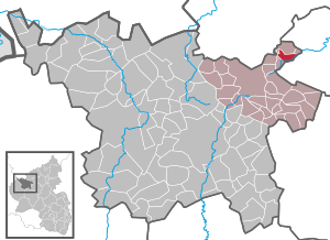
| Location of the local community Kirsbach in the Vulkaneifel district | ||
  |
||

Kirsbach is a municipality in the Vulkaneifel district in Rhineland-Palatinate . It belongs to the association community Kelberg .
geography
The place is in the Vulkaneifel Nature Park .
history
Kirsbach belonged to the late 18th century to the office of mayor Welcherath the Electoral Cologne Office Nürburg .
In 1794 French revolutionary troops occupied the left bank of the Rhine . Under the French administration , Kirsbach belonged to the canton of Adenau in the Rhine-Moselle department from 1798 to 1814 . Due to the agreements made at the Congress of Vienna in 1815 , the region became part of the Kingdom of Prussia . Under Prussian administration, the municipality of Kirsbach was assigned to the Adenau district in the Koblenz administrative district and was administered by the Kelberg mayor . This went on in 1927 in the Kelberg office and in 1968 in the Kelberg Association . After the First World War , the area was under French military administration . When the Adenau district was dissolved in 1932, Kirsbach joined the Mayen district . The region has been part of the state of Rhineland-Palatinate since 1946 and belonged to the French occupation zone until 1949 and 1955, respectively .
As part of the municipal reorganization of Rhineland-Palatinate, the community came on November 7, 1970 from the district of Mayen , which was dissolved at the same time, to the district of Daun (now the district of Vulkaneifel ).
politics
Municipal council
The council in Kirsbach consists of six council members, who in the local elections on May 26, 2019 in a majority vote were elected, and the honorary mayor as chairman.
coat of arms
|
|
Blazon : "Divided by silver over black, above a continuous black cross, below a silver angle crossed with a silver ax with gold." |
Attractions
- St. Joseph


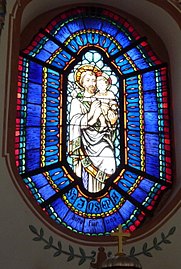


The Catholic branch church of St. Josef is located in Kirsbach. It was built as a baroque hall in 1920. The glass windows in the interior were created by Otto Linnemann in 1922.
Web links
- Internet presence of the local community Kirsbach
- To search for cultural goods of the local community Kirsbach in the database of cultural goods in the Trier region .
Individual evidence
- ↑ State Statistical Office of Rhineland-Palatinate - population status 2019, districts, communities, association communities ( help on this ).
- ↑ Official municipality directory (= State Statistical Office of Rhineland-Palatinate [Hrsg.]: Statistical volumes . Volume 407 ). Bad Ems February 2016, p. 156 (PDF; 2.8 MB).
- ^ The Regional Returning Officer Rhineland-Palatinate: Local elections 2019, city and municipal council elections
- ↑ General Directorate for Cultural Heritage Rhineland-Palatinate (ed.): Informational directory of cultural monuments - Vulkaneifel district. Mainz 2020, p. 34 (PDF; 4.6 MB).

Arbach | Basberg | Beinhausen | Bereborn | Berenbach | Berlingen | Berndorf | Betteldorf | Birgel | Birresborn | Bleckhausen | Bodenbach | Bongard | Borler | Boxberg | Brockscheid | Brückal | Darscheid | Down | Demerath | Densborn | Deudesfeld | Dockweiler | Dohm-Lammersdorf | Drees | Dreis-Brück | Duppach | Ellscheid | Esch | Feusdorf | Gefell | Gelenberg | Gerolstein | Gillenfeld | Gönnersdorf | Gunderath | Reverberation | Hillesheim | Hinterweiler | Höchstberg | Hohenfels-Essingen | Horperath | Hörscheid | Hörschhausen | Immerath | Jünkerath | Kalenborn scrubbing | Caperich | Katzwinkel | Kelberg | Kerpen (Eifel) | Kerschenbach | Kirchweiler | Kirsbach | Kolverath | Kopp | Kötterichen | Kradenbach | Lirstal | Lissendorf | Mannebach | More | Meisburg | Mosbruch | Mosquitoes | Mürlenbach | Neichen | Nerd | Neroth | Niederstadtfeld | Nitz | Nohn | Oberbettingen | Oberehe-Stroheich | Oberelz | Oberstadtfeld | Ormont | Pelm | Reimerath | Retterath | Reuth | Rockeskyll | Salm | Sarmersbach | Sassen | Saxler | Schalkenmehren | Scheid | Schönbach | Schüller | Protection | Stadtkyll | Steffeln | Steineberg | Steiningen | Strohn | Strotzbüsch | Üdersdorf | Udler | Uersfeld | Ueß | Utzerath | Üxheim | Wallenborn | Walsdorf | Weidenbach | Which council | Wiesbaum | Winkel (Eifel)