Hörscheid
| coat of arms | Germany map | |
|---|---|---|

|
Coordinates: 50 ° 13 ' N , 6 ° 53' E |
|
| Basic data | ||
| State : | Rhineland-Palatinate | |
| County : | Vulkaneifel | |
| Association municipality : | Down | |
| Height : | 516 m above sea level NHN | |
| Area : | 4.04 km 2 | |
| Residents: | 119 (Dec. 31, 2019) | |
| Population density : | 29 inhabitants per km 2 | |
| Postal code : | 54552 | |
| Area code : | 06592 | |
| License plate : | DAU | |
| Community key : | 07 2 33 031 | |
| Association administration address: | Leopoldstrasse 29 54550 Daun |
|
| Local Mayor : | Kurt Binz | |
| Location of the local community of Hörscheid in the Vulkaneifel district | ||

Hörscheid is a municipality in the Vulkaneifel district in Rhineland-Palatinate . She belongs to the community of Daun .
geography
The highest elevation in the district is the northeastern Kapp with 590 m above sea level. NHN . The village itself lies on a narrow, elongated hill from which the terrain slopes down on both sides. In the north of the village a wooded slope falls sharply down to the Hasenbach, south of the village there is sloping meadow terrain up to the Maubach. Both streams unite in the west of the district, the Maubach then flows into the Lieser at Boverath .
The Alf rises in the east of the district and flows south from there.
The Birkenhof and Sonnenhof residential areas also belong to Hörscheid .
Hörscheid is a street village that ends in a dead end. The newly built section of the A1 from Trier to Cologne runs west of the village . In 1982 Hörscheid was the district winner in the competition Our village should become more beautiful .
history
The area was already settled in the Neolithic . Celtic stone axes were found in the settlement area . The corridor Runkelhof shows traces of Roman settlement, here on the Roman road from Trier to Cologne stood a stone villa from the 2nd to 4th century. The Romans had diverted and channeled a nearby source of the Alf. The tunnel water pipe ran 1.30 m deep in the ground and ended in a well in the neighboring village of Darscheid , which has been lost.
The name of the village is derived from the Celtic word for "mountain forest" or "deer forest", but this is uncertain. The ending "-scheid" indicates an early medieval clearing. Hörscheid is mentioned for the first time in a document from 1465, according to this document it already existed in 1398. In the 16th century the settlement consisted of five fireplaces. The village had been part of the Daun office since the 14th century , which had belonged to Kurtrier since 1354 . Ecclesiastically, however, the entire Daun office belonged to the Archdiocese of Cologne . The area is predominantly populated by Roman Catholics , Hörscheid has belonged to the Darscheid parish since 1803 . The bell of the Catholic Brigidenkapelle was cast in 1678, so a chapel must have already existed at that time. It was renewed in 1850. The Protestant diaspora community is part of the Adenau deanery .
In 1787 there was a winter school in Hörscheid. Later the school children went to Darscheid in a one-class elementary school , which was closed in 1975. Since then, the Hörscheid children have attended the two-tier elementary school in Mehren . A kindergarten is also available in Darscheid.
During the so-called French period (1798 to 1814) Hörscheid was assigned to the canton of Daun in the Saar department . After the region in 1815, following the decisions on the Congress of Vienna the Kingdom of Prussia was awarded, the community was Hörscheid of 1816 under the administration of Mayor's down in the circle down , the part of the administrative district of Koblenz in the Rhine province was (1822).
Life in the Eifel was often tough for people because of the harsh climate and poor soil. Because of great hardship , a total of 31 people from Hörscheid emigrated to North America at the beginning of the 19th century . It was not until 1860 that the reforestation of the barren heath and improved agricultural methods were able to secure the permanent nutrition of the population. In 1912 the fields that had been dismembered by the division of the estate were merged. In 1931 a central water supply was built. In 1933 a large part of the heathland was cultivated .
- Population development
The development of the population of Hörscheid, the values from 1871 to 1987 are based on censuses:
|
|
politics
Municipal council
The local council in Hörscheid consists of six council members who were elected by a majority vote in the local elections on May 26, 2019 , and the honorary local mayor as chairman.
mayor
Hans Schuh was elected mayor by the local council on August 25, 2009 and replaced Walter Steinebach.
coat of arms
|
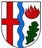
Blazon : "In silver a blue wave stick, in front a continuous red bar cross, behind over a green oak leaf a red flame."
The coat of arms was approved on May 7, 1991. |
|
| Justification of the coat of arms: The red cross on a silver background indicates that it has belonged to the Electorate of Trier for centuries . The blue wave rod symbolizes the source of the Alfbach. The green oak leaf documents that the name Hörscheid is interpreted as "mountain forest", as well as the fact that oak wood was extracted for tanning in the field of Gebrannter Berg . The red flame is the hallmark of the patroness St. Brigida. |
Attractions
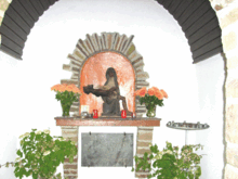
In addition to a chapel built in 1850 with a Baroque altar from 1738, which is consecrated to St. Brigida von Kildare , there is a picturesque saint's house built in the 1960s with a pietà made of reddish basalt . In addition to the chapel, the fountain square, built in 1980, a playground renovated in 2006 by the citizens themselves, and a community center with a fire station are also centrally located.
- See also: List of cultural monuments in Hörscheid
Economy and Infrastructure
The small village is home to three large farms, two of which are emigrant farms.
Web links
- Hans Mühlhaus: Small chronicle of a small Eifel village. In: Heimatjahrbuch 1977. Landkreis Vulkaneifel (Chronicle of Hörscheid).
- To search for cultural assets of the local community Hörscheid in the database of cultural assets in the Trier region .
Individual evidence
- ↑ State Statistical Office of Rhineland-Palatinate - population status 2019, districts, communities, association communities ( help on this ).
- ↑ State Statistical Office Rhineland-Palatinate (ed.): Official directory of the municipalities and parts of the municipality. Status: January 2019 [ Version 2020 is available. ] . S. 111 (PDF; 3 MB).
- ^ Georg Baersch: Description of the government district of Trier: edited according to official sources and on behalf of the royal family. Prussia. Government. Lintz, Trier 1849, p. 121 ( online edition at Google Books ).
- ↑ Erwin Schaefer: The Prussian administrative division in the early years of the Daun district. In: Heimatjahrbuch 1980. Vulkaneifel district, accessed on April 8, 2019 .
- ↑ State Statistical Office Rhineland-Palatinate - regional data
- ^ The Regional Returning Officer Rhineland-Palatinate: Local elections 2019, city and municipal council elections


