Kelberg
| coat of arms | Germany map | |
|---|---|---|

|
Coordinates: 50 ° 17 ' N , 6 ° 55' E |
|
| Basic data | ||
| State : | Rhineland-Palatinate | |
| County : | Vulkaneifel | |
| Association municipality : | Kelberg | |
| Height : | 480 m above sea level NHN | |
| Area : | 24.62 km 2 | |
| Residents: | 2026 (Dec. 31, 2019) | |
| Population density : | 82 inhabitants per km 2 | |
| Postal code : | 53539 | |
| Area code : | 02692 | |
| License plate : | DAU | |
| Community key : | 07 2 33 218 | |
| LOCODE : | DE KEG | |
| Community structure: | 5 districts | |
| Association administration address: | Dauner Strasse 22 53539 Kelberg |
|
| Website : | ||
| Local Mayor : | Wilhelm Jonas | |
| Location of the local community Kelberg in the Vulkaneifel district | ||
Kelberg is a municipality in the Vulkaneifel district in Rhineland-Palatinate . It is the administrative seat of the association municipality Kelberg , to which it also belongs. Kelberg is a state-approved climatic health resort and designated as a basic center according to state planning .
geography
location
Kelberg lies in the area of the Hocheifel and the Vulkaneifel and borders in the north on the communities Bauler , Wiesemscheid , Müllenbach from the Bad Neuenahr-Ahrweiler district, in the east on Reimerath , Mannebach , Bereborn , Kolverath , in the south on Mosbruch , Katzwinkel , Beinhausen and in West to Boxberg , Gelenberg , Bodenbach .
Community structure
- Kelberg (core town)
- Köttelbach : The place is named after the stream of the same name that meanders through the village. The area was already settled in ancient times, near today's Köttelbach there was a Roman estate .
- Hünerbach : the name Hünerbach means that this place was the only village of the Daun office in the Electorate of Trier behind (hönner) the Grenzbach between Kurtrier and Kurköln, the Trierbach . In 1688 the place received its first chapel, which was replaced by a new building in 1925/26.
- Zermüllen : The name of the place goes back to the name "Zur Mühle", as two mills once stood near the place.
- Rothenbach with Meisenthal: The name Rothenbach probably comes from a mineral spring near the town whose water is reddish in color due to its high iron content. Rothenbach was mentioned for the first time in 1563 in the tax list of the Kurier Amtshaus Daun, Meisenthal as early as 1459.
Streams
- Adense soaps
-
Trierbach (flows into the Ahr)
- Misery stream
- Hahnchenbach
- Köttelbach
- Hünerbach
- Kelberger Bach
- Juniper brook
- Herrenbach
- Zillesbach
- Zermüllenbach
- Trout stream
- Grinding soaps
- Langwiese soaps
- Krumbach
- Aelsbach
- Rothenbach
- Meisenthaler Mühlgraben
- Hühnerbach
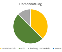
Floor areas
| Total floor area: | 24.62 km² |

|
| Agricultural area: | 9.25 km² | |
| Forest area: | 12.29 km² | |
| Settlement and traffic areas | 2.95 km² | |
| Water surface: | 0.13 km² |
history
Kelberg was mentioned for the first time in 1195, when the Archbishop of Trier Johann I acquired the Allod of Kelberg from Count Theoderich von Hoyenstaeden . But the area around Kelberg was already inhabited by Romans, which is proven by finds on the Hochkelberg , one of the highest mountains in the Eifel .
On June 25, 1215, goods at Kelberg were donated by the married couple Eberhard von Aremberg and Adelheid von Freusburg to Abbot Heinrich von Heisterbach to found the Marienstatt monastery . A von Kelberg family of knights also seems to have existed for a short time. The von Kelberg knight family is mentioned in a document from Count Gerhard von Are. In 1216 a Theodericus von Kelberg and 1301 a Gerhard von Kelberg are mentioned.
Before 1795 Kelberg was a market village. It is not known when Kelberg received the market rights. The term market place had a legal meaning and referred to the right granted by the sovereigns - for Kelberg the elector of Trier - to hold markets.
Until the end of the 18th century Kelberg belonged to the Electorate of Daun . After the occupation of the left bank of the Rhine by French revolutionary troops Kelberg was 1798-1814 seat of the mayor (mayor) of the Mairie Kelberg in Canton elms in the Rhine-Moselle department of the district Bonn . Due to the agreements made at the Congress of Vienna (1815), the region was assigned to the Kingdom of Prussia . The community was the seat of a mayor's office in the Adenau district ( Koblenz district ). 26 communities were administered by the mayor's office in Kelberg . In 1927 the mayor's office in Kelberg was renamed to Amt Kelberg. After the Adenau district was dissolved in 1932, the Kelberg district became part of the Mayen district . In 1968, Kelberg became the seat of the Kelberg Association . As part of the municipal reform , this was assigned to the Daun district on November 7, 1970 .
During the Second World War Kelberg was not spared from bomb attacks. On January 16, 1945 Kelberg was bombed by 36 Allied fighter bombers, which destroyed two thirds of the town center. A war cemetery on the Schwarzenberg near Kelberg today commemorates these victims .
On January 1, 1970, the four previously independent communities Hünerbach (82 inhabitants), Köttelbach (146 E.), Rothenbach (127 E.) and Zermüllen (182 E.) were incorporated into Kelberg.
- Population development
The development of the number of inhabitants in relation to today's municipal area; the values from 1871 to 1987 are based on censuses:
|
|
politics
Municipal council
The municipal council in Kelberg consists of 16 council members who were elected in the local elections on May 26, 2019 in a personalized proportional representation, and the honorary local mayor as chairman.
The distribution of seats in the municipal council:
| choice | CDU | UHW | KBV | FWG | SiW | total |
|---|---|---|---|---|---|---|
| 2019 | 4th | 3 | - | 5 | 4th | 16 seats |
| 2014 | 4th | 3 | 3 | 2 | 4th | 16 seats |
| 2009 | 5 | 4th | 3 | 4th | - | 16 seats |
| 2004 | 7th | 4th | 2 | 3 | - | 16 seats |
- UWH = Independent Voting Association Hochkelberg e. V.
- KBV = Kelberger Citizens Representation
- FWG = Free Voters' Group Kelbergerland e. V.
- SiW = voters community Sturm im Wald e. V.
coat of arms
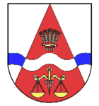
| Blazon : "In silver, a red tip covered by a blue-silver, confused wave bar, with five golden ears of wheat in a fan shape above and a golden scale below." | |
| Foundation of the coat of arms: The five ears of corn characterize the local community Kelberg, consisting of the five districts Kelberg, Hünerbach, Köttelbach, Rothenbach-Meisental and Zermüllen. The symbol also makes it clear that agriculture has been the main source of income for centuries. The Trierbach , which is symbolized by the wave bar, touches all five districts . The red tip was added to the coat of arms for the 675 m high Hochkelberg, which dominates the landscape. Kelberg was an important market town in the Middle Ages and, as one of the main towns in the district of Daun, had its own court. The golden balance is the symbol for the market and also for the high court. |
Attractions
- Catholic parish church of St. Vinzentius
- Schwarzenberg chapel with war cemetery
- History street
- Hochkelberg ( 675 m above sea level )
- Pointed cross
- Afels cross
- Rothenbacher mineral springs
See also:
Personalities
- Maria Eulenbruch (1899–1972), ceramist and art professor in Aachen
- Kurt Schwippert (1903–1983), sculptor and university professor
Infrastructure
Street
The federal highway 410 , which connects the place with the federal highway 1 and with the Nürburgring , and the federal highway 257 , which leads to the federal highway 48 and can be reached shortly, runs through Kelberg .
Public transport
As of December 8, 2018, Kelberg has had good public transport connections for the first time . This was made possible by the new public transport concept RLP Nord, which will gradually increase public transport connections throughout the north of Rhineland-Palatinate . The 520 bus connects Kelberg with new vehicles every hour (Saturdays and Sundays every 2 hours) to the district town of Daun (with stops in Boxberg , Neichen and Kradenbach ). Otherwise there is still a connection to Adenau with line 859 on weekdays (and with a change to Ahrbrück to the Ahr Valley Railway to Bonn Hbf ). A direct bus line between Kelberg, Adenau and Ahrbrück is planned here in the future.
In the center there is the Kelberg Busbahnhof stop, which is also a transfer point between line 520 from / to Daun and the RufBus lines - as well as the stop at the town hall and at the schools.
In addition, the surrounding communities are also connected to local public transport Monday to Sunday, at least every 2 hours, by so-called on-call buses.
These are divided into the following (RufBus) lines:
Line 507: Nitz ↔ Kelberg
The 507 runs every two hours from Monday to Sunday between Nitz and Kelberg with stops in Drees, Kirsbach, Welcherath, Brückal, Reimerath and Hünerbach. In addition, there is another journey early in the morning as a normal bus from Nitz via Kelberg to Daun.
Line 508: Meisenthal ↔ Kelberg
The 508 runs every two hours between Meisenthal and Kelberg from Monday to Sunday. Rothenbach and Zermüllen are also approached along the route. In addition, there is a normal bus from Müllenbach via Meisenthal, Rothenbach, Zermüllen and Köttelbach to Kelberg in the morning.
Line 509: Borler ↔ Kelberg
The 509 runs every two hours from Borler to Kelberg, Monday to Sunday. On the way, the places Bongard, Bodenbach, Gelenberg and Boxberg are also approached. The line has two different routes. While one route runs from Borler via Bongard and Boxberg to Kelberg, the other runs from Borler via Bodenbach, Gelenberg and Boxberg to Kelberg.
525: Ulmen ↔ Kelberg
Line 525 runs between Ulmen and Kelberg with stops in Mosbruch, Gunderath, Uersfeld, Höchstberg and Kötterichen. In addition, Kaperich and Ueß are approached in school traffic. With line 525, it should be noted at the weekend that Kelberg is not approached. Instead, the RufBus commutes between Uersfeld and Ulmen.
526: Ulmen ↔ Kelberg
Line 526 runs between Ulmen and Kelberg with stops in Hünerbach, Bereborn, Mannebach, Salcherath, Retterath, Lirstal, Kaperich, Uersfeld, Gunderath, Horperath, Berenbach and Furth.
528: Darscheid ↔ Kelberg
Line 528 runs between Darscheid and Kelberg with stops in Hörscheid, Gefell, Katzwinkel, Hörschhausen, Ueß, Mosbruch, Sassen, Kolverath, Bereborn, Hünerbach and Köttelbach.
education
- St. Vinzenzius Kelberg day care center
- Elementary and secondary school plus St. Martin Kelberg
Social facilities
- Regina-Protmann-Stift Kelberg
- Förderverein Freizeitheim Kelberg eV
Web links
- Internet presence of the local community Kelberg
- Local community Kelberg on the website of the Verbandsgemeinde Kelberg
- To search for cultural assets of the local community Kelberg in the database of cultural assets in the Trier region .
Individual evidence
- ↑ State Statistical Office of Rhineland-Palatinate - population status 2019, districts, communities, association communities ( help on this ).
- ^ A b State Statistical Office Rhineland-Palatinate: My village, my city. Retrieved July 26, 2019 .
- ↑ State Statistical Office Rhineland-Palatinate (ed.): Official directory of the municipalities and parts of the municipality. Status: January 2019 [ Version 2020 is available. ] . S. 112 (PDF; 3 MB).
- ↑ Official municipality directory 2006 ( Memento from December 22, 2017 in the Internet Archive ) (= State Statistical Office Rhineland-Palatinate [Hrsg.]: Statistical volumes . Volume 393 ). Bad Ems March 2006, p. 181 (PDF; 2.6 MB). Info: An up-to-date directory ( 2016 ) is available, but in the section "Territorial changes - Territorial administrative reform" it does not give any population figures.
- ^ The Regional Returning Officer Rhineland-Palatinate: Local elections 2019, city and municipal council elections


