
Esch (near Gerolstein)
| coat of arms | Germany map | |
|---|---|---|

|
Coordinates: 50 ° 22 ′ N , 6 ° 37 ′ E |
|
| Basic data | ||
| State : | Rhineland-Palatinate | |
| County : | Vulkaneifel | |
| Association municipality : | Gerolstein | |
| Height : | 540 m above sea level NHN | |
| Area : | 10.17 km 2 | |
| Residents: | 438 (Dec. 31, 2019) | |
| Population density : | 43 inhabitants per km 2 | |
| Postal code : | 54585 | |
| Area code : | 06597 | |
| License plate : | DAU | |
| Community key : | 07 2 33 022 | |
| Association administration address: | Kyllweg 1 54568 Gerolstein |
|
| Website : | ||
| Local Mayor : | Edi Schell | |
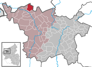
| Location of the local community of Esch in the Vulkaneifel district | ||
  |
||

Esch is a municipality in the Vulkaneifel district in Rhineland-Palatinate . It belongs to the Gerolstein community .
geography
The place is in the Vulkaneifel Nature Park . Esch also includes the Am Schwarzenpütz, Eschermühle (Hargartenmühle), Leuteratherhof, Mieshof, Reinertshof, Tannenhof and Wacholderhof residential areas .
history
Esch is on the Römerstrasse that led from Trier to Cologne ( Agrippastrasse ). The place was first mentioned in the 12th century. In the 16th century there was a court in Esch that exercised the jurisdiction over several places in the vicinity. Esch became famous for its witch trials in the 17th century. The village was badly damaged in World War II. A cemetery of honor is located south of Esch , testifying to the heavy fighting in March 1945.
- Population development
The development of the population of Esch, the values from 1871 to 1987 are based on censuses:
|
|
politics
Municipal council
The municipal council in Esch consists of twelve council members, who were elected by a majority vote in the local elections on May 26, 2019 , and the honorary local mayor as chairman.
coat of arms
|
|
Blazon : “In red the golden bust of St. Peter with a silver halo. In the right hand a silver book, in the left a silver key with the beard turned away. Above a golden shield, inside a red armored black lion, covered with a five-lipped, red tournament collar. " |
| Foundation of the coat of arms: The coat of arms of the municipality of Esch is modeled on an old aldermen's seal from 1620. The black lion indicates the former sovereignty of the Counts of Manderscheid-Blankenheim . The hl. Peter with his attributes key and book of heaven is the local patron of the community of Esch. |
Culture and sights
- List of cultural monuments in Esch
- List of natural monuments in Esch
- Oktoberfest in spring
- Mime and clown center
Web links
- Local community Esch on the website of the Verbandsgemeinde Obere Kyll
- To search for cultural assets of the local community Esch in the database of cultural assets in the Trier region .
- Brief portrait of Esch bei Hierzuland , SWR television
Individual evidence
- ↑ State Statistical Office of Rhineland-Palatinate - population status 2019, districts, communities, association communities ( help on this ).
- ↑ State Statistical Office Rhineland-Palatinate (ed.): Official directory of the municipalities and parts of the municipality. Status: January 2018 [ Version 2020 is available. ] . S. 74 (PDF; 2.2 MB).
- ↑ State Statistical Office Rhineland-Palatinate - regional data
- ^ The Regional Returning Officer Rhineland-Palatinate: Local elections 2019, city and municipal council elections
- ↑ Description of the coat of arms. Verbandsgemeinde Obere Kyll.

Arbach | Basberg | Beinhausen | Bereborn | Berenbach | Berlingen | Berndorf | Betteldorf | Birgel | Birresborn | Bleckhausen | Bodenbach | Bongard | Borler | Boxberg | Brockscheid | Brückal | Darscheid | Down | Demerath | Densborn | Deudesfeld | Dockweiler | Dohm-Lammersdorf | Drees | Dreis-Brück | Duppach | Ellscheid | Esch | Feusdorf | Gefell | Gelenberg | Gerolstein | Gillenfeld | Gönnersdorf | Gunderath | Reverberation | Hillesheim | Hinterweiler | Höchstberg | Hohenfels-Essingen | Horperath | Hörscheid | Hörschhausen | Immerath | Jünkerath | Kalenborn scrubbing | Caperich | Katzwinkel | Kelberg | Kerpen (Eifel) | Kerschenbach | Kirchweiler | Kirsbach | Kolverath | Kopp | Kötterichen | Kradenbach | Lirstal | Lissendorf | Mannebach | More | Meisburg | Mosbruch | Mosquitoes | Mürlenbach | Neichen | Nerd | Neroth | Niederstadtfeld | Nitz | Nohn | Oberbettingen | Oberehe-Stroheich | Oberelz | Oberstadtfeld | Ormont | Pelm | Reimerath | Retterath | Reuth | Rockeskyll | Salm | Sarmersbach | Sassen | Saxler | Schalkenmehren | Scheid | Schönbach | Schüller | Protection | Stadtkyll | Steffeln | Steineberg | Steiningen | Strohn | Strotzbüsch | Üdersdorf | Udler | Uersfeld | Ueß | Utzerath | Üxheim | Wallenborn | Walsdorf | Weidenbach | Which council | Wiesbaum | Winkel (Eifel)