Lissendorf
| coat of arms | Germany map | |
|---|---|---|

|
Coordinates: 50 ° 19 ′ N , 6 ° 36 ′ E |
|
| Basic data | ||
| State : | Rhineland-Palatinate | |
| County : | Vulkaneifel | |
| Association municipality : | Gerolstein | |
| Height : | 430 m above sea level NHN | |
| Area : | 10.37 km 2 | |
| Residents: | 1118 (Dec. 31, 2019) | |
| Population density : | 108 inhabitants per km 2 | |
| Postal code : | 54587 | |
| Area code : | 06597 | |
| License plate : | DAU | |
| Community key : | 07 2 33 041 | |
| Association administration address: | Kyllweg 1 54568 Gerolstein |
|
| Website : | ||
| Local Mayor : | Rudolf Mathey | |
| Location of the local community of Lissendorf in the Vulkaneifel district | ||

Lissendorf is a municipality in the Vulkaneifel district in Rhineland-Palatinate . It belongs to the Gerolstein community .
geography
location
The place is in the Eifel . The Dennerthof, Mühlenbachhof and Sonnenhof residential areas also belong to Lissendorf .
climate
The annual precipitation is 838 mm. The precipitation is in the upper third of the values recorded in Germany. Lower values are registered at 70% of the measuring stations of the German Weather Service . The driest month is April, with the most rainfall in December. In December there is 1.5 times more rainfall than in April. Precipitation varies only minimally and is extremely evenly distributed over the year. Lower seasonal fluctuations are recorded at only 5% of the measuring stations .
history
Lissendorf is located on the former Roman road Trier – Cologne (Agrippastraße). Numerous side streets favored the settlement of this area in Roman times. Roman grave finds near the place prove this settlement.
Lissendorf owes its first documentary mention to the Prümer Urbar , a list of goods from the Prüm Abbey from 893. In the Middle Ages, a noble family "von Lissendorf" was mentioned. However, this family only gained regional importance. From the 14th century, the place came under the rule of the House of Manderscheid-Blankenheim . In the 16th century the village belonged to the county of Gerolstein .
During the French era , Lissendorf was the seat of a cantonal administration in the Saar department .
An important date in recent local history was the completion of the Cologne – Trier railway line with the construction of the local train station at the end of the 19th century.
- Population development
The development of the population, the values from 1871 to 1987 are based on censuses:
|
|
politics
Municipal council
The local council in Lissendorf consists of 16 council members, who were elected in a personalized proportional representation in the local elections on May 26, 2019 , and the honorary local mayor as chairman. The 16 seats in the municipal council are divided between two groups of voters.
coat of arms
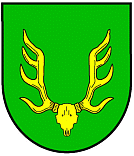
| Blazon : "In green the golden antlers with the grind of an eight-tender." | |
| Foundation of the coat of arms: The local community of Lissendorf has adopted the coat of arms of the local noble family von Lissendorf. However, the tinging of this coat of arms could no longer be reconstructed. Lissendorf therefore adopted the deer antlers as a figure, but chose the coloring himself. |
Culture and sights
In Lissendorf there are 14 individual monuments, including
- the Catholic parish church of St. Dionysius , a neo-Romanesque hall building from 1886/87 and
- the interlocking "Lf" (Lissendorf - dispatcher), the oldest, still preserved lever interlocking with cable technology of the Eifel route . The structure, erected in 1912, consists of quarry stone masonry with partially cantilevered wooden construction on the upper floor.
- Attractions
traffic
The Lissendorf stop is on the Eifelbahn ( Cologne - Euskirchen - Gerolstein - Trier ), on the local rail passenger transport
- the Eifel-Express (RE 22) Cologne – Euskirchen – Gerolstein with a connection to Trier (RB 22) and
- the Eifel-Bahn (RB 24) Cologne – Euskirchen – Kall , during peak hours to Gerolstein
run.
In Lissendorf the former Dümpelfeld – Lissendorf railway branched off ("Middle Ahr Valley Railway") .
The tariff of the Verkehrsverbund Region Trier (VRT) and the tariff of the Verkehrsverbund Rhein-Sieg and beyond the tariff area the NRW tariff apply to all local public transport .
Personalities
- Albert Caspers (1933–2015), Chairman of Ford Germany and President of the soccer club 1. FC Cologne
- Marco Weber (* 1975 in Daun), politician ( FDP ), grew up in Lissendorf
Web links
- Local community Lissendorf on the website of the Gerolstein community community
- To search for cultural assets of the local community of Lissendorf in the database of cultural assets in the Trier region .
- Private page about Lissendorf
Individual evidence
- ↑ State Statistical Office of Rhineland-Palatinate - population status 2019, districts, communities, association communities ( help on this ).
- ↑ State Statistical Office Rhineland-Palatinate (ed.): Official directory of the municipalities and parts of the municipality. Status: January 2019 [ Version 2020 is available. ] . S. 115 (PDF; 3 MB).
- ↑ State Statistical Office Rhineland-Palatinate: My village, my city. Retrieved February 11, 2020 .
- ^ The Regional Returning Officer Rhineland-Palatinate: Local elections 2019, city and municipal council elections.
- ↑ Description of the coat of arms on the website of the Gerolstein municipality
- ↑ General Directorate for Cultural Heritage Rhineland-Palatinate (ed.): Informational directory of cultural monuments - Vulkaneifel district. Mainz 2020, p. 35 f. (PDF; 4.6 MB).


